![]()
 |
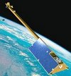
Harding Helps Estimate Forest Biomass
Accepted ICESat GRL Paper Provides First Satellite Laser Altimeter Estimate |
 |
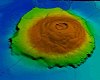
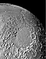
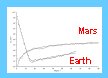
Frey and Students Seek Age Variations in Mars Lowlands
GSA Presentation Reveals Unusually Young Basement in Only One Area |
![]()
 |
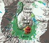
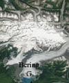
Sauber and Co-workers Document Glacial Thinning
ICESat Paper Accepted for Publication |
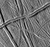 |
Hurford Estimates Elastic Lithosphere Thickness on Europa
Recent Paper Accepted for Publication in Icarus |
![]()
 |
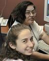
Interns Find Research Opportunities in Planetary Geodynamics
Summer Students Contribute to Lab's Work on Moon and Mars |
 |
Purucker, Sabaka Contribute to World Digital Magnetic Anomaly Map
Release of New Compilation Expected in 2007 |
![]()
 |
Purucker and Whaler Paper Accepted by JGR - Planets
New Model of Mars Crustal Magnetization Anomalies has Tectonic Detail |
![]()
 |
Muller Models Earthquake Processes, Effects
Two Papers Describe Likely Fault Geometry, Stress Change in Turkey |
 |
Bills Looks at Spin Control across the Solar System
Recent Papers Range from Mercury to Jupiter, include Mars Eclipses |
![]()
 |
Planetary Geodynamics Turns Out for LPSC 36
Ten Papers Authored, Co-authored at Lunar and Planetary Science Conference |
![]()
 |
Purucker Article Accepted by EOS
Magnetic Snapshot Reveals Deep Structure of Sumatra Earthquake Zone |
 |
Stress on Rocks Generates Electric Currents
Freund Leads Effort Connected to Possible Earthquake Precursor Signals |
![]()
Please note the change: This is the last monthly Science Highlight from the current Geodynamics Branch which, along with other organizations in the Laboratory for Terrestrial Physics (Code 920), will cease to exist by their current names at the end of 2004. As part of the Goddard Space Flight Center unification of Earth and Space Sciences into a single Science and Exploration Directorate, the Geodynamics Branch (old Code 921) becomes part of the Solar System Exploration Division with the new name Planetary Geodynamics Laboratory (PGL, Code 698). Science Highlights from the PGL will continue in 2005. Our web page address remains geodynamics.gsfc.nasa.gov.
 |
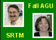
Geodynamics Branch Members Contribute to Fall AGU Meeting
Papers, Press Conferences and Editorships Highlight Involvement in Annual Meeting |
 |
Harding Represents ICESat Land Studies at AGU Press Conference
Work on Vegetation Height, River Flow, Global Topographic Control is Highlighted |
![]()
 |
Roark Delivers "Museum-Version" of GRIDVIEW to Smithsonian
Interactive Analysis Software will be used by Air and Space Museum Visitors |
![]()
 |
Taylor Given Medal for Geological Analysis of Satellite Geophysical Data
Excellence Medal for Earth Sciences� is from World Mineralogy Organization |
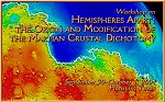 |
Frey Gives Invited Talks about Buried Basins and Early Mars
Timing of Major Events and Origin of Crustal Dichotomy are Discussed at Two Meetings |
 |
Geodynamics Personnel Sought for Review, Committee Positions - 1
Sauber Serves on InSAR Working Group, Asked to Serve on UNAVCO Facilities Committee |
 |
Geodynamics Personnel Sought for Review, Committee Positions - 2
Purucker asked to Help in Five-Year Review of USGS Geodynamics Program |
 |
Lowman's Paper on Astronomy from the Moon Published
Paper at the International Lunar Conference 2003 Urges Sub-millimeter Observations |
 |
Harding and USGS Colleagues Involved in Mount St. Helens Re-Mapping
New Activity Spurs Lidar Mapping to Detect Changes Since 2003 |
![]()
 |
Summer Students, Visitors Swell Branch Population
Every summer a large number of visitors joins the regular Geodynamics Branch research staff |
![]()
 |
Taylor Paper on Mars Magnetic Anomalies Accepted for Publication
Icarus Paper Shows Evidence for Reversals and Perhaps Some Polar Wander |
 |
Sauber Research on Glacier-Earthquake Link Highlighted
NASA Press Conference Describes How Glacial Retreat May Advance Earthquake Timing |
![]()
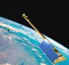 |
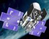
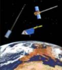
Purucker, Sabaka and Hulot Help Make SWARM a Winner
ESA Picks Magnetic Field Constellation as its New Earth Science Mission |
 |
Nazarova Leads Effort to Provide Rock Magnetic Properties
USGS, NASA to to Combine Data Bases for National Geophysical Data Center |
![]()
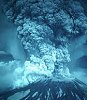 |
Sakimoto Shares Career-defining Moment at Special Forum
Close-up of Mt. St. Helens Eruption Related to Students at Geo Forum |
 |
Geodynamics Branch Contribution to EGU Annual Meeting
Carabajal and Harding Report on SRTM Assessment using ICESat Data |
![]()
 |
Mentors and Students Attend Lunar and Planetary Science Conference
Students Make Major Contributions to Papers at 35th Annual Meeting
Code 921 Well Represented at Lunar and Planetary Science Conference
|
![]()
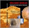 |
Sakimoto Contributes Chapter to New Book on Solar System Volcanism
"Volcanoes on Mars: The Global View" is Chapter 6 in Volcanic Worlds |
![]()
 |
Two Summer Interns make Semifinals in Science Talent Search
Stern and Frey have Success with Summer Research on Martian Gullies |
![]()
 |
Geodynamics Branch Contributions to Special Fall AGU Sessions
Code 921 Well Represented at 2003 American Geophysical Union Meeting |
 |
Geodynamics Branch Contributions to Special Fall AGU Sessions - 1
Hulot and Langlais Discuss Possible Cause of "The Disappearing Dipole" in session on The Earth's Declining Magnetic Field and Possible Future Reversal |
 |
Geodynamics Branch Contributions to Special Fall AGU Sessions - 2
Purucker, with Whaler, Fox-Maule and Olsen, Investigates Crustal Magnetic Fields on Earth and Mars |
 |
Geodynamics Branch Contributions to Special Fall AGU Sessions - 3
Sauber Describes Early ICESat Observations of Alaskan Glaciers |
 |
Geodynamics Branch Contributions to Special Fall AGU Sessions - 4
Harding and Carabajal Describe Early ICESat Observations of Forest Canopies |
![]()
 |
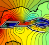
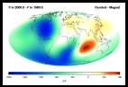
Comprehensive Magnetic Field Model Finds Many Fans, Many Uses
Sabaka and Model in Heavy Demand for a Variety of Applications |
 |
Summer Students Double the Population of the Geodynamics Branch
High School, Undergraduates and Grad Students Pump up Research Productivity |
 |
Sanchez Study Shows Effects of Atmospheric Torques on Mars
Paper Published in Journal of Geophysical Research (Planets) |
![]()
 |
Two Papers Presented at 6th International Conference on Mars
Frey, Sakimoto Talk about Earliest History, Planetary Volcanism |
![]()
 |
Cohen Visits USGS Center for Earthquake Research in Memphis
Is Asked to Serve on National Earthquake Hazard Reduction Panel |
![]()
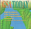 |
Puget Sound Lidar Consortium Featured as GSA Today Cover Article
Harding and USGS Colleagues Report Very Successful Lidar Mapping Results |
| Sakimoto Mentors Winning Science Fair Project on �Water on Mars
Erin Frey Wins 5 Awards at 2003 Intel International Science and Engineering Fair |
![]()
 |
Spotlight: Mest Publishes Geologic Map of Mars Sub-Quadrangle
Work is Part of Thesis Research on Fluvial Evolution of Martian Surface |
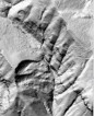 |
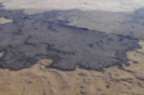
Mt. Rainier Hazards Mapped with High Resolution LIDAR:
Harding Sets Specs, Leads Project with USGS |
![]()
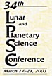 |
Geodynamics Branch Personnel Present Papers at Houston Meeting:
Bills, Frey, Mest, Roark and Sakimoto Author and Co-Author Papers on Mars, Jupiter Satellites, and Educational-Outreach at 34th Lunar and Planetary Science Conference |
 |
Spotlight: Stockman Gives Keynote Address at Millersville University:
Women in Mathematics and Science Conference Attracts Teachers and Students |
 |
Rubincam Paper May Explain 1000 Year Changes in Earth Rotation:
�Lava Lamp� Model for Gravitational Core-Mantle Coupling to be Published in Journal of Geophysical Research |
![]()
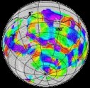 |
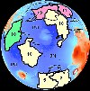
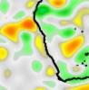
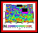
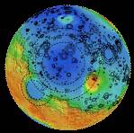
Whaler and Purucker Find �Triple Junction� Magnetic Signature on Mars:
Magnetic Anomaly Pattern Similar to That of Terrestrial Plate Tectonic Features |
![]()
 |
Yates and Lowman Contribute to Orbital ISS-EarthKam Activity:
Space Station Middle School Project Teaches Remote Sensing Techniques, Earth Science |
 |
UPDATE: Sauber and Team Study Seismic Risk Near Alaska Launch Facility: SRTM, Landsat-7 Data Used to Evaluate Likelihood of Earthquakes at Kodiak Island |
![]()
 |
Sauber and Team Study Seismic Risk Near Alaska Launch Facility:
SRTM, Landsat-7 Data Used to Evaluate Likelihood of Earthquakes at Kodiak Island |
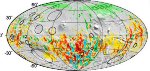 |
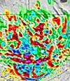
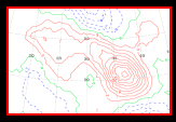
Langlais Study Compares Mars Magnetic Anomalies with Craters:
New Model of Mars Magnetic Field Combines High and Low Data Shows Improved Spatial and Amplitude Resolution |
![]()
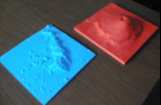 |
921 Teams with 691 on Successful Educational DDF Proposal
Sakimoto, Stockman, Roark and Frey Involved in 3-Dimensional Model Making for Classroom Teacher Kits Demonstrating Comparative Planetary Surface Features |
 |
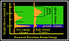
Harding Contributes to Improved Biomass Prediction Capability
Biomass Estimated from LIDAR Waveform Data for Three Different Forest Types |
![]()
 |
Frey, Sakimoto and Roark Represent Branch at Denver GSA Meeting "Early Mars", Earth-Mars Comparative Volcanology, and Interactive Software for Geoscience Educational Use are Hot Topics |
![]()
 |
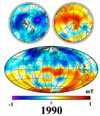
Four Represent Geodynamics Branch at 4th Oersted Team Meeting Purucker, Sabaka, Taylor and Voorhies all attend, present at Copenhagen meeting |
![]()
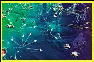
 Sakimoto, Idaho State Colleagues Search for "Mars on Earth"
![]()
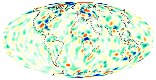
 Geodynamics Branch Contributions to Oersted Magnetic Field Studies. Magnetic dip pole located, Antarctic lithospheric anomalies confirmed
 Lowman Publishes 4th Book on Looking at the Earth from Space. "Exploring Space, Exploring Earth" newly released by Cambridge Press
![]()
 Purucker Helps Organize, Conduct New Virtual Session at Spring AGU. Electronic session ties international community together without the need for travel
 Purucker Selected for SWARM Mission Advisory Group (MAG) by ESA. Group will set requirements for constellation mission to study Earth's magnetic field
![]()
 Paper Compares Satellite Crustal Magnetic Anomaly Measurements. Taylor Leads Study on Kursk Region Using New CHAMP Data
![]()
 Small Volcanoes on Mars Have Trend Suggesting Volatile Control. Sakimoto Paper at 33rd Lunar and Planetary Science Conference Shows
Volcanoes Become Steeper Toward the Poles Where More Ground Ice is Likely
Small Volcanoes on Mars Have Trend Suggesting Volatile Control. Sakimoto Paper at 33rd Lunar and Planetary Science Conference Shows
Volcanoes Become Steeper Toward the Poles Where More Ground Ice is Likely
 GRL Paper on Mars Floods Cited in Science, Science News. Sakimoto Co-Authors Paper Describing Recent Volcanic and Fluvial Outpourings
 Age of Crustal Dichotomy on Mars Constrained by MOLA Data. Frey Presents Paper at 33rd Lunar and Planetary Science Conference Showing
Very Ancient Age for Most Basic Feature of Martian Crust
Age of Crustal Dichotomy on Mars Constrained by MOLA Data. Frey Presents Paper at 33rd Lunar and Planetary Science Conference Showing
Very Ancient Age for Most Basic Feature of Martian Crust
![]()
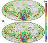
 Major Paper on Recent Comprehensive Magnetic Model Accepted.
![]()
 Authors Compare Satellite-Derived Magnetic Spectra of Two Planets. Paper by Voorhies, Sabaka and Purucker "On Magnetic Spectra of Earth
and Mars" accepted by Journal of Geophysical Research - Planets
Authors Compare Satellite-Derived Magnetic Spectra of Two Planets. Paper by Voorhies, Sabaka and Purucker "On Magnetic Spectra of Earth
and Mars" accepted by Journal of Geophysical Research - Planets
 Two Investigations Ready to use SRTM Data. Harding and Sauber Present Side-by-Side posters at AGU
Special Session on SRTM (Shuttle Radar Topography Mission) Studies
Two Investigations Ready to use SRTM Data. Harding and Sauber Present Side-by-Side posters at AGU
Special Session on SRTM (Shuttle Radar Topography Mission) Studies
![]()
 Approved DDF Study Tied to Global Earthquake Satellite System. Lowman and Yates successfully propose study of intraplate seismicity based on their Digital Tectonic Activity Map.
![]()
 Tectonic Plate Coupling and Elastic Thickness Derived from GPS Data. Cohen and Darby use modeling, GPS-derived motions in New Zealand to study properties, earthquake hazard of Australian-Pacific plate.
![]()
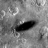
 Discovery of buried impact basins on Mars provides first real constraint on age of the lowlands and the martian crustal dichotomy. Frey and co-workers (in press, GRL) find lowlands to be extremely old.
 Satellite magnetization model marks edge of North America craton. Purucker and co-workers (in press, GRL) suggest strong crustal anomalies define boundary between magnetic basement and non-magnetic coastal sediments.
![]()
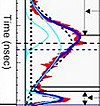
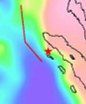
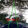
 ICESat Calibration Study Leads to "Discovery" of "Unknown" Channel. Bills and co-workers find extremely shallow channel in Nevada Desert.
![]()
 Back to Planetary Geodynamics Home Page
Last updated: September 26, 2005
Curator:
Responsible NASA Official:
Send us your comments
Privacy, Security, Notices