![]()
![]()
|
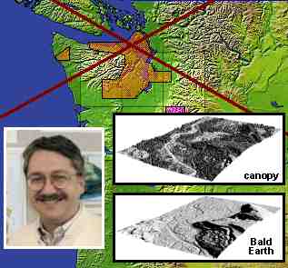
Harding collaborates with USGS and local agencies in a study of the Puget Sound area of western Washington State. He uses airborne lidar data to determine shoreline terrace elevations and slopes and to characterize other landforms formed by active faulting. Lidar data is able to penetrate the forest canopy (which is extensive in this area) and will be used to evaluate SRTM canopy penetration. Landform studies help understand seismic risk. |
Contact: Dave Harding, GSFC, Code 921 (harding@core2.gsfc.nasa.gov)
![]()
|
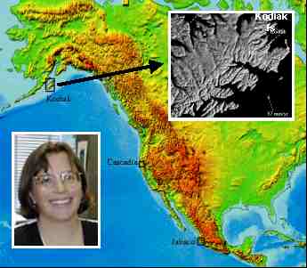
Sauber to date has concentrated on Kodiak Island, one of 3 subduction zone areas in which she is interested. She has acquired GPS data over several field seasons to determine both shoreline elevations and crustal motion due to the convergence of the Pacific Plate with North America. Future studies will be done in Oregon and Mexico. SRTM data will be evaluated and used to help characterize topography and evaluate seismic risk in these areas. |
Contact: Jeanne Sauber, GSFC, Code 921 (sauber@core2.gsfc.nasa.gov)
![]()
 Back to Geodynamics Science Highlights
Responsible NASA official: Dr. Herbert Frey