![]()
A single measurement of the magnetic field from a near-Earth
satellite actually measures the combined contributions from
the core (the main field of the Earth), the crust (both remanent
and induced sources), and from currents in the ionosphere and
magnetosphere. GSFC has for years had the most complete
description of the Earth's field from a simultaneous estimation
and parameterization of all of these contributions. A paper on
a recent version of these “comprehensive models”, CM3, by
Terry Sabaka and co-authors has recently been accepted for
publication by Geophysical Journal International. This model
spans the period 1960-1985, but newly available satellite data
has already allowed extension of that model to 2000. The newer
version includes data not only from Magsat and POGO but also
from the Danish Oersted
satellite and a global distribution
of surface magnetic observatories.
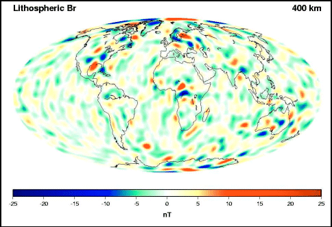
The crustal field derived from this
(shown above) reveals many
more N-S anomalies which were
generally missing in earlier (non-
comprehensive) versions. This is
due to the former need for filtering
along-track to remove ionospheric
currents from the observed signal.
See, for example, the weak positive
features (yellow and red) in South
America along the Andes Mountains.
|
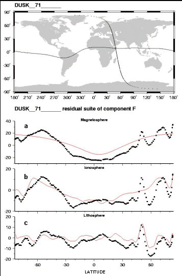
Residuals (black dots) left after successive removal of (a) long wavelength core and crustal fields, (b) fields from the magnetosphere, (c) ionospheric fields. The final model lithospheric field estimated (red line) shows a sharp peak over the well-known Kursk iron ore region at 50 degrees N. |
 Contact: Terry Sabaka, GSFC, Code 921 (sabaka@geomag.gsfc.nasa.gov)
![]()
 Back to Geodynamics Science Highlights
Responsible NASA official: Dr. Herbert Frey