
 |
While the primary goal of the Ice, Cloud and land Elevation Satellite (ICESat) is to measure elevation changes of the vast polar ice sheets, it also collects data over large temperate mountain glaciers (e.g. in Alaska, Patagonia, etc.), which are sensitive indicators of climate change. The glaciers of the southeastern Alaska coastal region include some of largest temperate glaciers on Earth and may contribute one third of the total glacier meltwater entering the global ocean. For example, the Alaskan Malaspina Glacier and its tributaries have an area of ~5,000 km2, with the largest piedmont lobe of any known temperate glacier. Changes in temperate glacier elevation (and therefore thickness) can be measured over time using satellite and other data. |
|
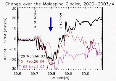
Three ICESat-minus-SRTM (2000) elevation profiles over the Malaspina Glacier in Alaska show thinning of 20-25 meters at latitude 59.8 (arrow). |
Jeanne Sauber and co-workers B. Molnia (USGS), C. Carabajal (NVI, GSFC), S. Luthcke (GSFC), and R. Muskett (Un. Alaska) compared ICESat-derived elevations and surface characteristics with Shuttle Radar Topography Mission (SRTM) data to investigate the Malaspina Glacier. In a paper "Ice elevations and surface change on the Malaspina Glacier, Alaska" recently accepted for publication in Geophysical Research Letters, they find elevation differences between ICESat Laser 1-3 observations (February 2003 - November 2004) and an SRTM-derived DEM from February 2000. Decreases of up to 20-25 m over a 3-4 year time period were observed across the folded loop moraine on the southern portion of the Malaspina Glacier (see Figure). This documents short-term glacial thinning in this portion of Alaska, and demonstrates the ability of remote sensing for long-term monitoring of glaciers using high quality satellite elevation data.
 |
Jeanne Sauber is a geophysicist in Code 698 (Planetary Geo-dynamics Lab). Her recent work includes the effects of glacial loading and unloading on the frequency of Alaskan earthquakes. She also is involved with the calibration/validation effort for ICESat. |
 Back to Planetary Geodynamics Science Highlights
Responsible NASA official: Dr. Herbert Frey