|
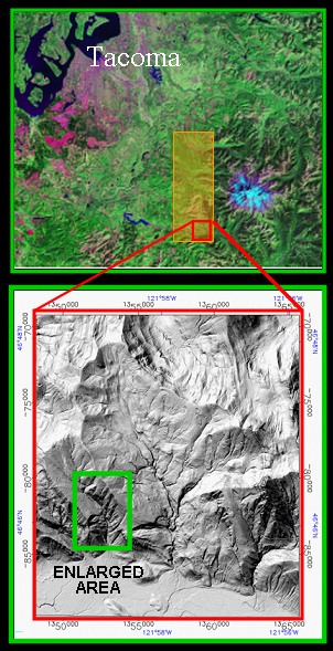
Airborne laser swath mapping (ALSM) of a 500 km2 area on the west side of Mount Rainier, WA (orange rectangle on false-color Landsat TM image) has been completed in a project led by David Harding (921) in collaboration with the USGS. The area poses significant natural hazards to the region, including earthquakes, landslides, and lahars (mudflows) triggered by melt outbursts from glaciers atop Rainier (light blue in TM image) that can extend as far as Tacoma. The lidar mapping was conducted (using specifications from Harding) by TerraPoint, LLC under contract to the Stennis Space Center Scientific Data Buy Program. The ALSM data yields maps of vegetation height and spectacular bald Earth Digital Elevation Models (DEMs) of the topography beneath the dense vegetation cover, a significant improvement on the best available USGS DEMs. The data will be used to identify hazard-generated landforms and study the processes that create them. |
| Landsat TM image (top) and bald Earth elevation image from recent lidar mapping (bottom). |
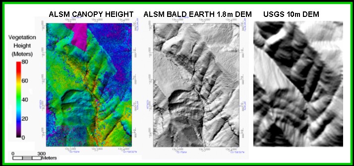
Enlarged area images of Canopy Height, Bald Earth, and USGS DEM
Contact: David Harding, GSFC, Code 921 (David.J.Harding@nasa.gov)
![]()
 Back to Geodynamics Science Highlights
Responsible NASA official: Dr. Herbert Frey