|
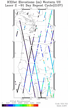
Carabajal (Code 926) and Harding (Code 921) are using elevation data from the Geoscience Laser Altimeter System (GLAS) on the Ice, Cloud and Land Elevation Satellite (ICESat) to evaluate the accuracy of the interferometric Digital Elevation Models produced by the Shuttle Radar Topography Mission (SRTM). In a presentation at the April European Geophysical Union annual meeting they document elevation differences between ICESat and SRTM C-band elevations for three regions, the northwestern United States, a glaciated area in southern Alaska, and a portion of the Amazon basin. The ICESat waveform measurement of vertical structure is used to evaluate C-band radar penetration in vegetation canopies. This analysis was conducted to assess the utility of SRTM DEM data in studies of surface processes and elevation change. |
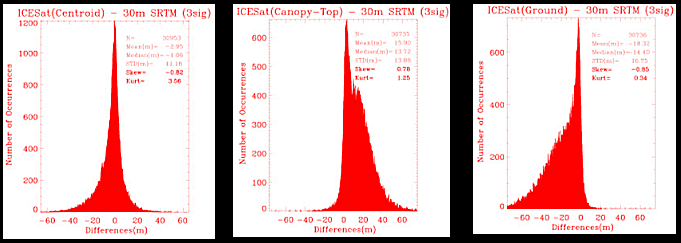
Histograms for the northwestern US of SRTM elevation differences with respect to the ICESat waveform centroid, highest surface and lowest surface exhibit well defined peaks near 0 that are associated with unvegetated areas. Positively and negatively skewed tails in the highest surface and lowest surface distributions, respectively, are associated with areas of vegetation cover where the C-band phase center elevation is located within the canopy.
 Back to Geodynamics Science Highlights
Responsible NASA official: Dr. Herbert Frey