![]()
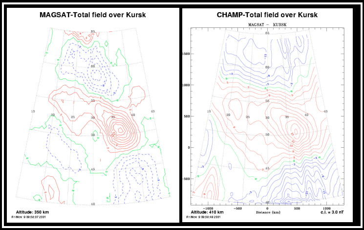
One of the strongest crustal magnetic anomalies seen at satellite
elevation is the so-called Kursk anomaly, named for the famous
iron-ore region over which it lies. This feature has been studied
since Magsat first produced a global map of crustal anomalies, and
Pat Taylor and co-workers have been mainly responsible for revealing
the complex nature of this feature. Now Taylor has led a new study that
compares - in a paper in Geoscience Series/International Association
of Geodesy Symposia - total magnetic field data from the recently launched
German CHAMP mission with that from
Magsat and the Danish
Oersted mission. Using
similar techniques but
data from each mission
separately (including
calculation of the core
field for subtraction
from the observations),
Taylor et al. produced anomaly maps
for Magsat (right, epoch 1980) and for
CHAMP (far right, epoch 2001). Both
show nearly identical anomaly patterns
with a very strong positive overlying
the main portion of the Kursk iron-ore
region. The flanking negatives are also
similar. Slight differences in the total
magnitudes of the anomalies are due
to the slightly different average orbital
elevations (350km for Magsat, 410km
for CHAMP). The authors suggest the
expected high quality vector data from CHAMP should help resolve the
nature of the known remanent contribution to this feature. Furthermore,
use of data from satellites at different altitudes will make it possible to
determine the depth of the source likely source body.
 Contact: Pat Talor, GSFC, Code 921 (ptaylor@ltpmail.gsfc.nasa.gov)
![]()
 Back to Geodynamics Science Highlights
Responsible NASA official: Dr. Herbert Frey