|
The cover article in the June issue of GSA Today features a report on the activities of the Puget Sound Lidar Consortium (PSLC). The paper “High-Resolution Lidar Topography of the Puget Sound Lowland, Washington – A Bonanza for Earth Science”, is authored by Ralph Haugerud of the USGS, David Harding (Code 921), and others of the PSLC. The article describes results of lidar mapping in the Puget Lowland of Washington state, conducted by TerraPoint, LLC under contract to the PSLC, and includes discovery of 5 active fault scarps hidden beneath the vegetation of the dense temperate rain forest. Subsequent studies of the scarps (to determine the age, magnitude, and the sense of motion of recent earthquake slip events) is detailed. Applications of lidar data to measure shoreline terraces uplifted by earthquakes, improve the identification and mapping of landslides, and characterize glacial geomorphology in the region, is discussed. |
|
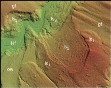
Landslides revealed in a shaded relief lidar image of ground topography below the vegetation. Green to red color represents increasing elevation. View is 3.5 km wide and the grid spacing is 1.8 m. Geomorphic units shown by letters are gf = glacially fluted surface; ow = glacial outwash surface; ls = landslide, 1 (oldest) to 3 (youngest); Hf = Holocene fluvial surface. |
The June issue of GSA Today describes the program for the Fall GSA Annual meeting in Seattle, and has wide circulation amongst geoscientists and geotechnical professionals. The editor requested the feature article so that these important new results, which are highly relevant to the seismic and other hazards of the Seattle region, would be highlighted.
Contact: Dave Harding, GSFC, Code 921 (David.J.Harding@nasa.gov)
![]()
 Back to Geodynamics Science Highlights
Responsible NASA official: Dr. Herbert Frey