![]()
|
A DDF proposal to focus attention on intraplate seismic activity has been won by Paul Lowman and Jacob Yates. One impetus for this proposal is the Global Earthquake Satellite System (GESS) initiative which is looking at InSAR and other remote sensing techniques for monitoring crustal motion related to earthquakes. The current study builds on a Digital Tectonic Activity Map produced by Lowman & Yates under a previous DDF. |
|
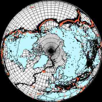
Northern hemisphere projection of the Earth showing volcanic centers (red) active in the last 1 million years and earthquake epicenters (black) for magnitudes > 3.5 between 1963 and 1998. Although most seismicity is associated with plate boundaries, substantial and significant earthquake activity does occur within the interiors of plates. Figure derived from A Digital Tectonic Activity Map by P.D Lowman and J. Yates. |

|
Objectives of the DDF Study: Provide a comprehensive global picture of intraplate earthquake epicenters Clarify relations between seismic activity, lithospheric stress, plate motion, and regional tectonic structure Highlight active or potentially active intraplate areas worthy of study by a Global Earthquake Satellite System Produce maps and reports on the above for the scientific and educational communities |
![]()
 Back to Geodynamics Science Highlights
Responsible NASA official: Dr. Herbert Frey