
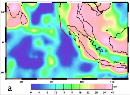
The great earthquake of 26 December 2004, which gave rise to the devastating tsunami that swept over a large part of the SE Indian Ocean, occurred along a subduction zone in Sumatra where one oceanic plate slides beneath another. Many subduction zones around the world have pronounced signatures not only in marine altimetry and magnetic data, but also in satellite-elevation crustal magnetic data. Satellite magnetic data provide important information on the deep structure of the Earth's crust. The figure below shows how magnetic crustal thickness in the region of the subduction zone increases to the east and northeast, in the direction of subduction at the place where the cold crustal slab dives into the Earth's mantle. Other large scale oceanic crustal structures (ridges, basins) are also evident in this map.
 |
Mike Purucker is a staff geophysicist with Raytheon Technical Services and has worked at the Goddard Space Flight Center for 15 years. He is well-known for studies of crustal magnetic anomalies on both Earth and Mars, and is a member of the Mission Advisory Group for the upcoming European Swarm Mission. |
Contacts: Mike Purucker, GSFC Code 698, purucker@geomag.gsfc.nasa.gov
 Back to Planetary Geodynamics Science Highlights
Responsible NASA official: Dr. Herbert Frey