Geodynamics Science Highlight
SCIENCE HIGHLIGHT
Geodynamics Branch, Code 921
November 2004
Roark Delivers "Museum-Version" of GRIDVIEW to Smithsonian
Interactive Analysis Software will be used by Air and Space Museum Visitors
Last month Jim Roark delivered a "museum-friendly" version of the GRIDVIEW analysis program to the Smithsonian's National Air and Space Museum where it will be used in a guided exhibit. Visitors will be able to interact with the same Earth and Mars topographic data typically used by scientists, and experience the same thrill of discovery.
 GRIDVIEW, an IDL-based interactive graphics tool
for analysis of topographic and other data, was first
developed by Jim Roark (SSAI) to aid researchers
in the Geodynamics Branch and elsewhere in their
study of topographic data from the Mars Orbiting
Laser Altimeter (MOLA). GRIDVIEW features the
ability to interactively stretch color representations
of the topographic data and implement a variety of
different kinds of analysis functions, for example:
contouring, profiling, slope and distance calculation,
overlaying of other data, and plotting circular rings
for mapping craters and other landforms. It can be
used on any image-based data, and over the last
several years has been continuously improved with the addition of new features, such as an area and volume calculation and fly-through capability. Many of these improvements have been done with the help of summer students, especially Christine Masuoka (see Science Highlights for March 2004 and August 2004).
GRIDVIEW, an IDL-based interactive graphics tool
for analysis of topographic and other data, was first
developed by Jim Roark (SSAI) to aid researchers
in the Geodynamics Branch and elsewhere in their
study of topographic data from the Mars Orbiting
Laser Altimeter (MOLA). GRIDVIEW features the
ability to interactively stretch color representations
of the topographic data and implement a variety of
different kinds of analysis functions, for example:
contouring, profiling, slope and distance calculation,
overlaying of other data, and plotting circular rings
for mapping craters and other landforms. It can be
used on any image-based data, and over the last
several years has been continuously improved with the addition of new features, such as an area and volume calculation and fly-through capability. Many of these improvements have been done with the help of summer students, especially Christine Masuoka (see Science Highlights for March 2004 and August 2004).
Recently Roark was part of a group that won a second DDF proposal to provide topographic models, data, and classroom materials for the comparison of large scale topographic features on Earth and Mars. These models and their associated lesson materials are now being tested in classrooms.
In the current DDF, a partnership with Steve Williams of the Smithsonian Air and space Museum, Roark has produced a simplified "museum-friendly
" version of GRIDVIEW that visitors can use to explore the topography of Earth and Mars and do many of the same kinds of analysis that professional scientists do, such as determining the depth of the large canyons on Mars, or calculating the slopes on large volcanoes. Some examples of the GRIDVIEW products and capabilities are shown at the right.
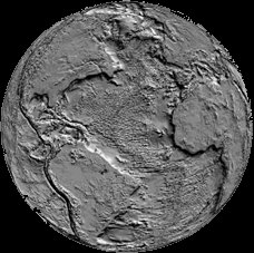
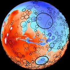
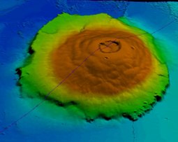
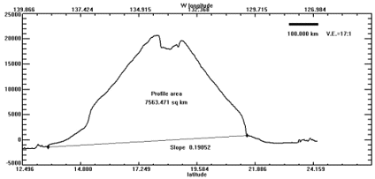
Shaded relief version of Earth's topography (top left) and colored MOLA topography for Mars with large impact craters shown (top right) as produced by GRIDVIEW. Below are a shaded perspective elevation view of Olympus Mons on Mars, the largest volcano in the solar system (bottom left) and
a profile derived using one of
GRIDVIEW's many tools (bottom right).
The program also allows user
selection of coloring schemes,
the ability to stretch and shade
those colors, contouring, slope
and distance calculation.
Contacts: Jim Roark, GSFC, Code 921, jim.roark@gsfc.nasa.gov
 Back to Geodynamics Science Highlights
Responsible NASA official: Dr. Herbert Frey
This page maintained by Jim Roark (SSAI)
Last modified on November 15, 2004