In a paper given at the Spring Joint Assembly AGU Meeting in Montreal, Canada, Katherine Nazarova of Raytheon ITSS at the Geodynamics Branch, Goddard Space Flight Center, announced that NASA and USGS have agreed to combine their separate rock magnetic properties databases into what will be the most complete collection of its kind.
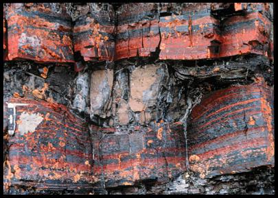
Interpretation of satellite-elevation magnetic anomaly data, such as derived from NASA's 1980 Magsat satellite, more recently from the Danish Oersted and German CHAMP satellites, and in the future from ESA's SWARM (see companion highlight, this month) requires knowledge of the magnetic properties of the rocks of the Earth's crust. Information on such properties does exist for many locations around the world, but until recently has not been easily available to the wider community. Several years ago, Nazarova undertook a project to gather such information from the many individual institutions where it exists and put the data into a user-friendly, web-base system that would be available to anyone with Internet access. The resulting NASA data base, supported by the Solid Earth and Natural Hazards Program of the Earth System Enterprise, now contains data on more than 19,000 samples, mostly from outside the USA, like the banded iron formation at far right. A separate compilation by the USGS contains information on over 17,000 different samples, many from outcrops in the western US.
Now the two organizations are combining their data and providing it in the web-based format developed by Nazarova. The new combined database will soon be available through the National Geophysical Data Center (NGDC, World Data Center A) in Boulder, CO, managed by NOAA. Jonathan Glen is the USGS co-author and Susan McLean in the NGDC representative.
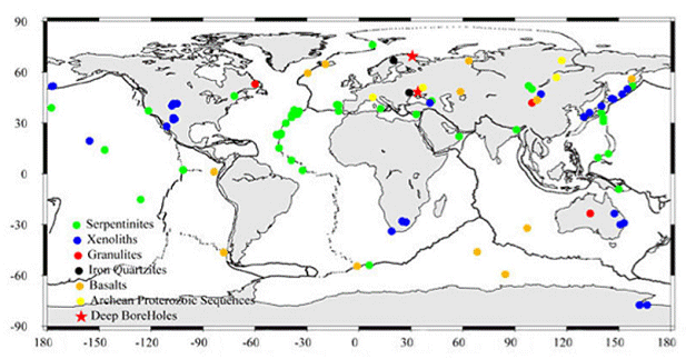
Map from the NASA database showing locations of rock samples for which magnetic properties are available. Clicking a location links to the properties in the database.
The database features a clickable map (above) showing locations of samples whose properties are available, color-coded by rock type. Entries include rocks from Iceland, from the deepest borehole in the world (over 12 km deep, located in the Baltic) as well as samples dredged from the ocean floor.
More information on this story is available from the GSFC website at www.gsfc.nasa.gov/topstory/2004/0517magnet.html

Contact: katia Nazarova, GSFC, Code 921, katianh@geomag.gsfc.nasa.gov
 Back to Geodynamics Science Highlights
Responsible NASA official: Dr. Herbert Frey