Geodynamics Science Highlight
SCIENCE HIGHLIGHT
Geodynamics Branch, Code 921
January 2003
Sauber and Team Study Seismic Risk Near Alaska Launch Facility:
SRTM, Landsat-7 Data Used to Evaluate Likelihood of Earthquakes at Kodiak Island
Because it lies near an active subduction zone, much of Alaska is subject to large and
damaging earthquakes. This is true also of Kodiak Island where NASA maintains a
launch facility, where future building plans may need revisiting due to a recent study
by Jeanne Sauber and G. Carver, W. R. Lettis and R.C. Witter.
|
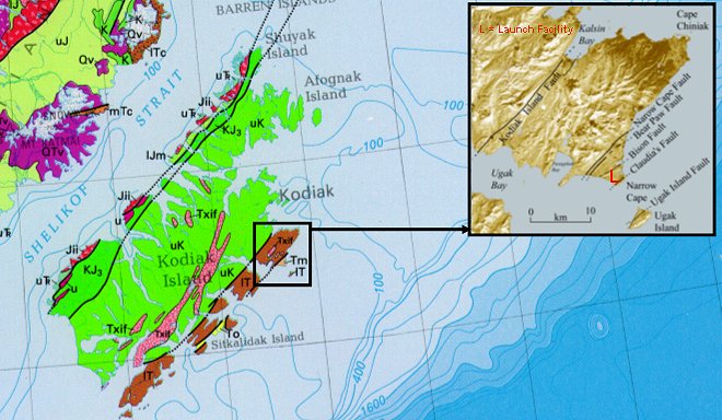
Geologic map of Kodiak island with inset to show location of Launch Facility. |
SRTM and Landsat-7data were used to re-assess the seismic hazard of the island.
A 15-40m high terrace becomes much higher (80m) at Narrow Cape, and 100 m high
at Ugak Island.
Landsat images and air photos show many fault-associated
lineaments crossing and displacing the terrace, with surface
ruptures in recent geologic time. The largest is related to the
Narrow Cape fault, which vertically displaces the terrace by 240 m.
A linear scarp is coincident with the fault and stream offsets of up to
35 m are also seen. Three more lineaments were associated with
the Holocene-age Bear Paw, Bison, and Claudia faults, two of which
each had 3 post-glacial events with displacements of 1 to 2 m. Carbon
14 dating suggests earthquake recurrence intervals of 2500 to 3000 years.
Contact: Jeanne Sauber, GSFC, Code 921 (jeaanne@ltpmail.gsfc.nasa.gov)

 Back to Geodynamics Science Highlights
Responsible NASA official: Dr. Herbert Frey
This page maintained by Jim Roark (SSAI)
Last modified on Jan 21, 2003