 |
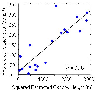
The first estimate of important forest parameters from satellite laser altimetry is described in a paper in press in the special ICESat issue of Geophysical Research Letters by Lefsky, Harding and others, "Estimates of forest canopy height and above ground biomass using ICESat". This work builds on a long history of collaboration between Dave Harding and Mike Lefsky using airborne lidar data to develop algorithms for the characterization of forest canopy structure and above ground biomass. Detailed studies of the ICESat waveforms, described in GRL by Harding and Carabajal, (see below) enable an estimate of the canopy height (below, center) and above ground biomass (below). The demonstration that this can be done from satellites (e.g., ICESat) offer opportunities for long-term monitoring of forests. |
|
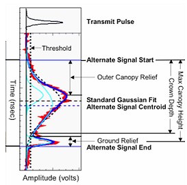
Waveform measurement of the vegetation canopy and ground vertical structure within GLAS footprints (Harding and Carabajal, GRL, 2005) |
|
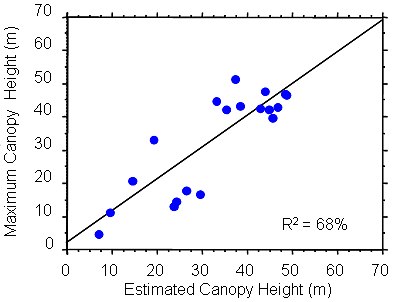
Maximum canopy height measured at field plots coincident with GLAS footprints vs. estimate from waveform extent and SRTM DEM relief (Lefsky, Harding & 6 others, GRL, 2005) |
|
Field-measured aboveground biomass vs. square of estimated canopy height (a surrogate for volume) (Lefsky, Harding & 6 others, GRL, 2005) |

|
Dave Harding is a geophysicist in the Planetary Geodynamics Lab specializing in laser altimetry. He is a member of the ICESat science team and is leading the development and validation of ICESat's land elevation and canopy structure products. His studies include mapping hidden faults beneath vegetation cover to help assess earthquake hazards as well as studies of biomass. |
 Back to Planetary Geodynamics Science Highlights
Responsible NASA official: Dr. Herbert Frey