SLA-02 Science Results

SLA-02
Shuttle Laser Altimeter II

First Science Results

color bar

SLA-02 operated successfully with approximately 3 million laser pulses fired.

All scientific visualizations using SLA-02 data have been developed and carried out by SLA team member James Frawley (Herring Bay Geophysics at NASA's GSFC). Text and interpretations have been provided by science team members Garvin, Harding, Blair, and Bufton.


color bar

see caption
Postscript

Total vertical roughness (TVR) at 100 m spatial scales as measured from SLA-01 echoes for different landcover units on Planet Earth. Only those echoes that were unsaturated were used to derive TVR values, which represent a total canopy assemblage height in forested areas where the local topography is of low slope (< 3 degrees). In desert areas it is a good measure of the total variation in local relief at the scale of SLA's surface footprint, i.e., 100 m. One can see that Terrestrial deserts are not as rugged in a vertical sense as forested surfaces, but are nonetheless relative rugged.

color bar

SLA-02 ground tracks
Postscript Tiff

color bar

see caption
Postscript

First geolocated SLA-02 transect across the Eastern US, featuring horizontal positional control at 100 m level and vertical precision at full resolution of the instrument (1-2 m for bare ground). SLA-02 team member Jim Frawley geolocated the raw SLA-02 data by employing a feature matching algorithm that allowed the data to be compared against the best available digital elevation models for this area.

The figure shows a topographic gradient perspective of the topography of Virginia, W. Virginia, Maryland, Pennsylvania, and Delaware, with the geolocated ground track of the SLA-02 transect superimposed. At the same time, colored "sticks" are featured which are scaled to show the magnitude of the vertical structure of landcover (ie. total vertical roughness or TVR, which is a measure of the effective canopy height in vegetated areas with moderate to low local slopes). The topography from SLA-02 and (in black) the best available digital topography are shown in the middle box. In the lowermost panel, histograms of the total vertical roughness for different land cover classes are plotted, revealing the variability in the relative relief of the forested parts of the transect. Apparently most of the vegetation is around 30-35 feet in height, although taller stands are also observed.

Further examples of precision geolocated SLA transects will appear as the entire dataset is downloaded from the instrument hard disk drives over the next few weeks.

color bar

see caption
TVR (or Total Vertical Roughness)

A shaded relief map of Africa is illustrated with the position of SLA-02's first landcrossing pass shown in color-coded format. The colors are derived from an analysis of the SLA-02 echoes (waveforms) such that we identify ground and all vertical structure within our footprint (100 m diameter). Since most of the transect featured in arid, vegetation poor terrain, the total vertical roughness at 100 m length scales is generally less than 10-20 m. A histogram of the total vertical roughness is shown below for this pass.

color bar

see caption


A sampler of 6 representative SLA-02 echoes is shown, including rough Mediterrannean water, rugged desert, and various forms of vegetated landscapes.

color bar

see caption
TVR (or Total Vertical Roughness)

First SLA-02 measurements of the effective heights of landcover in the middle USA from Georgia over Virginia, Maryland, Pennasylvania, etc.. These total vertical roughness (aka canopy assemblage heights in areas of low relief and low slope) values are measured by means of SLA's echoes, which describe the surface height distribution within each of its 100 m diameter footprints. As can be seen from the histogram of landcover vertical roughness plotted below, most of the local vertical structure of landcover in the Eastern US is less than about 30-40 feet, but trees up to 150 feet are observed.

color bar

see caption


Example SLA-02 echoes for various landcover units in the Eastern USA. Echoes describe the time history of the arrival times of the photons scattered off of the Earth's surface within each of SLA's 100 m diameter footprints. We derive various statistical parameters describing the echoes including, in certain circumstances, something we call ECH which stands for Effective Canopy assemblage Height. In cases where the ground is flat, the ECH represents an average tree height parameter. This is important to measure in areas where forest biomass is under attack from people wishing to convert tree-covered land to developments. In one case SLA-02 apparently observed a building in an area of cultivation (lower right).

color bar

see caption


Example of SLA-02 transect across the central USA featuring the within-footprint total vertical roughness (TVR) of each 100 m diameter footprint along the profile, color-coded as a "stick".

The height of the sticks are proportional to the height of the canopies or other roughness elements at 100 m scales. A histogram of the canopy height distribution for various landcover classes is listed below the image format.

color bar

see caption


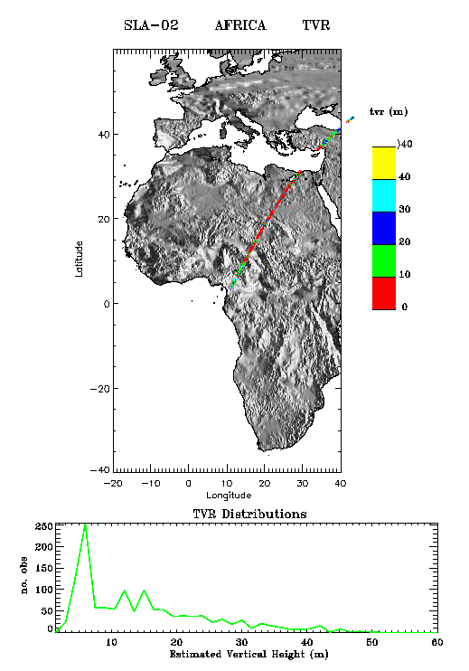
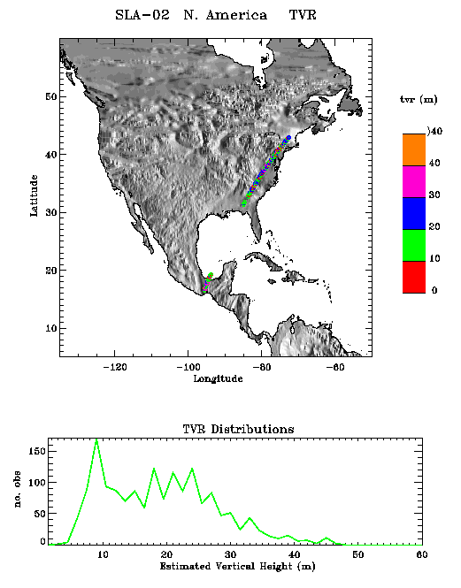
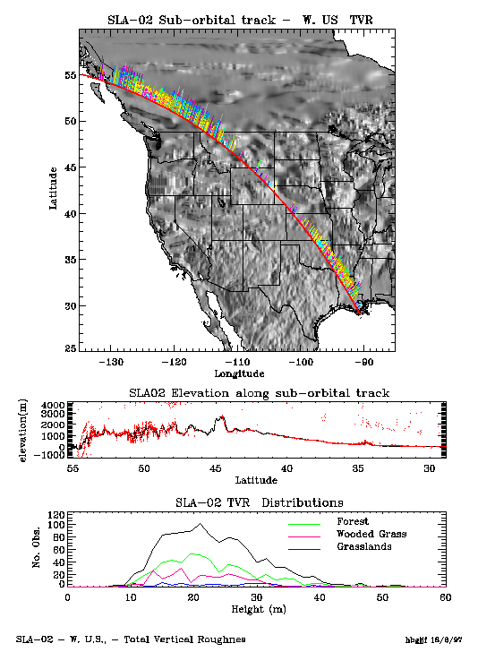
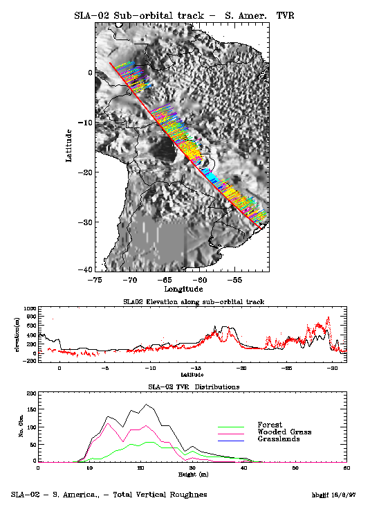
Example of an SLA-02 transect across the headwaters of the Amazon (western Amazon basin), showing the variability of landcover classes and the heights of vegetation (as total vertical roughness or TVR within each 100 m diameter footprint generated by SLA-02). Histograms of the TVR (which is a measure of canopy assemblage height in cases where local slopes are low) are also plotted.

color bar

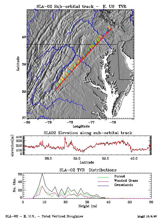
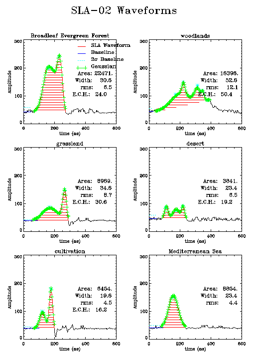
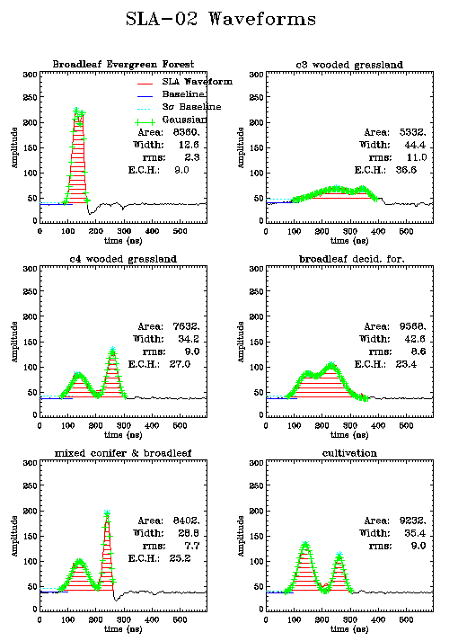
In summary, the variable gain amplifier (VGA) that was implemented on SLA-02 has circumvented the waveform saturation issue that we faced with our SLA-01 experiment (Jan. 1996 on STS-72).

color bar

Stay tuned for further quick-look science examples, courtesy the SLA-02 science team and the outstanding visualization tools and talents of Jim Frawley (SLA-02 science team member).

color bar

Back to LAPF home

Responsible NASA officials: James Garvin, David Harding
Web Curator: Jim Roark (SSAI)
Email roark@denali.gsfc.nasa.gov with comments or suggestions
Last modified November 14, 1997