Volcano Topography and Volcanic Hazards: Topographic Characterization
and Monitoring of Volcanoes
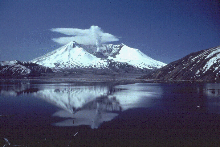
Photo of Mt. St. Helens from the collection of the Cascade Volcano Observatory.
The Players
The Motivation
Monitoring the topography of potentially
hazardous
volcanoes is important both for documenting past activity and recognizing
the potential for future activity. Many volcanoes are capable of causing
floods, mudflows, and landslides, as well as volcanic plumes and flows.
Besides being life-threatening, all of these catastrophic events can cost
agriculture, government, private property owners and industry millions of
dollars. Volcanoes such as Mt. Saint Helens and Mt. Rainier are located
near highly populated, urban areas. Mt. Saint Helens, once thought to
be dormant, reawakened in 1980. Thus declaring it's hazard potential and
proving that long term monitoring of Cascade volcanoes is necessary. In
the past Mt. Rainier has produced enormous mud flows, some of which
reached the Seattle-Tacoma metropolitan area. Topographic monitoring of
summit areas could reveal pre-eruption indicators, such as; large scale
tilts and bulges over active magma chambers, subsidence of glacial ice due
to near-surface magma, or the appearance of a new crater or vent.
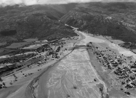
Armero, Colombia was destroyed by mud flows on November 13, 1985.
More than 23,000 people were killed when mud flows swept down from the erupting Nevado del Ruiz volcano. Photo from Cascade Volcano Observatory, by R.J. Janda.
The Research
Topography is an important parameter used to describe volcanic
landforms. However, high precision methods
for rapidly determining the complex topography of volcanoes, to the
resolution necessary for remote monitoring and hazard prediction, have
only recently emerged. Since the middle 1980's, a small group of scientists
and engineers at NASA's Goddard Space Flight Center (GSFC) have been
developing airborne and spaceborn laser altimeter methods for measurement
of elevations of terrestrial surfaces, including volcanic landforms.
These technological developments have enabled scientists to
gather very accurate topographical information for the study of several
active and potentially hazardous volcanoes, including:
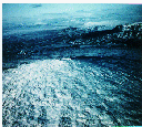
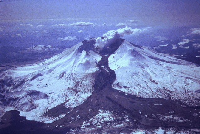
This photo shows Mt. Saint Helens' mudflows
triggered by the March 1982 eruption. Photo from the Casade Volcano Observatory, by Thomas Casadevall. Mt. Saint Helens is located in the Cascade range, in Washington state.
It's last major eruption occured in 1980; since then numerous smaller
eruptions have occured. Topographic cross-sections of the summit region
(including the dacite lava dome) have been aquired with airborn laser
altimeter systems since 1987, with continuously improving reliability
and accuracy. In September 1993, cross-sections of the Mt. Saint
Helens' central dome were aquired with no more than a few tens of cm
vertical error. This data can serve as the basis for continued monitoring
of the changing topography of the dome as well as the entire edifice.
 Link to NASA photos and topography model of the St. Helens dome.
Another member of the Cascade range in Washington, Mt. Adams has been
inactive during historical times. Multiple topographical cross-sections of
Mt. Adams were aquired during the airborne laser altimeter surveys of 1993.
In contrast to more recently active Cascade volcanoes, Mt. Adams shows
rather gradual slopes, with 80% of local slopes (i.e. on baselines < 10m) less than 60 degrees.Photo from the collection of the Cascade Volcano Observatory.
Mt. Rainier, which last erupted approximitly one hundred and fifty years
ago, is also a member of the Cascade mountain range, close to
the Seattle-Tacoma metropolitan area. As part of the airborne laser
altimeter surveys of 1993, multiple topographic cross-sections
of Mt. Rainier were aquired. Mt. Rainier is relatively steep; 80%
of it's local slopes (i.e. on baselines < 10m) are less than 30 degrees. This slope curve
suggests that Rainier is transitional between the long-period dormancy
of Mt. Adams, and the recent eruptive activity of Mt. Saint Helens.
The laser altimetry, in combination with other methods, could provide
the basis for characterizing changes in hazardous volcanoes in terms of
their topographic characteristics. This approach has been adopted for a
NASA-supported multi-year study of the topography of the summit region
of Mt. Rainier,scheduled to commence in 1995.
Check out these wire mesh topography plots of Mt. Rainier.
Photo from the collection of the Cascade Volcano Observatory.
For a topographic comparison of Mt.SaintHelens, Mt.Adams and Mt.Rainier visit this page.
 Skjaldbreidur
Located in
Iceland, Skjaldbreidur is a classic lava shield.
Skjaldbreidur will be monitored by RADARSTAT, an orbital remote
sensor. RADARSTAT will aquire monthly SAR images of Skjaldbreidur,
which will then be analyzed in an attempt to measure the spacial
and areal changes associated with the volcano.More information about Skjaldbreidur can be found here.
Photo by Ingiblorg Kaldal.
 Pico
Pico
Pico is located in the Azores Islands, an island chain west of Spain
in the Atlantic Ocean. Uncharacteristicly quiet during the past few decades,
Pico last erupted in 1963. Pico makes up a significant portion of the
island of Pico, and is reminiscent of the stratocones of the Pacific rim.
However, Pico rises 7700 feet above sea level, and displays a summit region topographically more akin to an oceanic shield than to a pyroclastic stratocone. The work
with Pico, done in collaboration with Prof. V. H. Forjaz of the University dos Azores and his colleagues, has focused on analyzing it's upper reaches using laser altimetry. Scientists have observed summit region local slopes consistently above 45 degrees with evidence for slump scars as well. The Shuttle Radar Laboratory imaged Pico in October 1994, and the NASA laser altimeter remote sensing mission to the Azores in September 1994 aquired 4 transects across the edifice, with 3 m horizontal sampling and sub-meter vertical precision. Don't miss these fabulous
NASA aerial images and topography models of Pico and the Azores.
Fogo, located in the Cape Verde Islands, is a major mid-Atlantic volcano
which was last active in 1951. Fogo previously displayed a long period of
semi-continuous eruptive activity between 1500 and 1761. Today, scientists
are studying Fogo island with hopes of understanding the ongoing eruptive
activity and the nature of any human hazards it might pose. A SPOT Pilot
Project focusing on monitoring and documenting the results of the ongoing
volcanic eruption of Fogo is imminent. In addition, efforts are afoot to
overfly the Fogo volcano with NASA aircraft for the purpose of airborne laser
topographic observations using either NASA airborne laser altimeter or SAR
interferometer sensors. Data will also be used to guide field studies of
the eruption, and as a basis for future volcano monitoring studies.Don't miss these amazing
Related volcanology research:
Other interesting volcano pages:
Back to Geodynamics Home Page
page created by:
Lisha McCormick
Goddard Space Flight Center
National Space Club Scholars
7/27/95
 Mt. Saint Helens
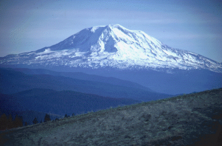 Mt. Adams
 Mt. Rainier
 Skjaldbreidur
 Pico
Pico Fogo
Fogo