While deployed at Dryden Research Flight Facility at Edwards Airforce Base,
we flew over our GPS ground station for calibration and verification of
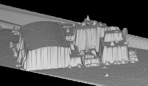
instrument performance. In our flight path was the hangar system our
temporary offices were set up in. I thought it would be interesting to
look at the data of those hangars, and here it is. You can clearly see
the dome shape of the hangar, and various antnennas on the higher roofs.
Cars are parked all around the building, and are pretty obvious just to
the right of the main hangar. This is a group of builidings, so it makes
for some interesting topography.
Back to the RASCAL IMAGES page...
Return to the RASCAL home page...