GEODYNAMICS 2002:
THE YEAR IN REVIEW
TABLE OF CONTENTS
GEODYNAMICS STAFF AND VISITORS
Invited Review Summary of SC Alaska Crustal Deformation
Comprehensive Modeling Paper Published
SWARM Constellation Selected by ESA
Four Attend Oersted International Science Team Meeting
Magnetic Study of Rocks in the Kola and Krivoy Rog Deep Boreholes
Narrow-Scale Flow at Top of Earth’s Core
Magsat, Oersted and Champ Data Compared
Biomass Measurements from Lidar Mapping
Quantifying Plains Volcanism on the Eastern Snake River Plains and Mars
Planetary Geology and Geophysics
Recent Studies of Mars Magnetic Anomalies
Orbital-Rotational-Climatic Interaction
Orbital Noise and Climate Fluctuation
A Spin-up for Asteroid 951 Gaspara?
Models of Earth and Mars Topography for Classroom Use
GEODYNAMICS BRANCH PUBLICATIONS IN 2002
GEODYNAMICS BRANCH PRESENTATIONS IN 2002
Major Scientific Meetings (LPSC, Spring AGU, Fall GSA, Fall AGU)
Oersted and CHAMP Science Team Meetings
GEODYNAMICS 2002:
THE YEAR IN REVIEW
Laboratory for Terrestrial Physics
Thank you for your interest in our annual report. In the pages that follow you will find highlights of our research activities for calendar year 2002. This year we include only those studies which reached some level of maturity this year in each of the five main areas in which we work (Crustal Deformation, Geomagnetism, Topography and Surface Change, Planetary Geology and Geophysics, and Orbital-Rotational-Climatic Interaction). [More extensive background material on our research areas was described in the 2001 Annual Report, which is also available as a link through our web site.] This year we have also included a report on an important Educational/Outreach effort designed to develop educational materials for teachers. The final section of the Annual Report includes publications submitted, accepted and published in 2002 and presentations given by members of our Branch both at major national and international meetings and elsewhere.
Our group consists of 10 civil servants, and about the same number of full-time contractors and visiting scientists. Last year 15 students and other visitors spent time working with us. Despite our relatively small size, we are involved in a wide range of Earth Science and Space Science (planetary) research and mission support activities. Our people are contributing to the currently operating Mars Global Surveyor, and the Oersted and CHAMP magnetic satellites, and are providing support to the just-launched ICESat mission. Our staff, in addition to their highly successful individual research activities, are heavily involved in proposal and paper reviews as well as mission design and readiness reviews in both Earth and Space Sciences.
A pictorial overview of our group is shown on the following pages. Our branch web pages contain more detailed information on our staff and visitors, as well as monthly science highlights. We invite you to visit us there at http://geodynamics.gsfc.nasa.gov.
We hope you enjoy reading this annual description of our activities, and welcome any comments you might have with regard either to the content or the format of this presentation. Please feel free to contact me or any of the individuals in our group at any time.
--Herb Frey
Head, Geodynamics Branch
Who we are - (details and contact information)

Geodynamics Visitors 2002 (details)
GEODYNAMICS BRANCH RESEARCH
2002 HIGHLIGHTS
Research in the Geodynamics Branch covers a wide range of subjects in the broad disciplines of geophysics, geology, geodesy and geodynamics for both the Earth and solid planetary bodies, especially Mars. Surface and satellite data, models derived from these, and other observational and theoretical information are used to help improve our understanding of the evolution of the Earth's core, mantle and crust, and the character and evolution of Earth and planetary surfaces. Geodynamics includes studies of the processes which operate or have operated to produce the observed present-day state and motions of the crust and surface.
Current research in the Geodynamics Branch falls into five major areas: Crustal Deformation, Geomagnetism, Topography and Surface Change, Planetary Geology and Geophysics, and Orbital-Rotational-Climatic Interaction. Below are described some of the current activities in each of these areas that reached a mature level this last year. Background for each of these areas can be found in the 2001 Annual Report and in other links available through this web site. Additional progress and ongoing work for this year is indicated by papers given at national and international meetings as well as by papers submitted and accepted (as well as published) during the year.
Invited Review Summary of South Central Alaska Crustal Deformation (Steven Cohen)
The 1964 Alaska earthquake is the largest known seismic event (moment magnitude, Mw=9.2) to strike North America and the second largest event to occur anywhere in the world within the modern observational era. The region of south central Alaska that was directly affected by this earthquake (i.e. from Cordova to Kodiak Island and Anchorage to well offshore; see Figure 1) lies at the boundary between the converging Pacific and North America tectonic plates. Over the past few decades a tremendous body of scientific information has been developed about the earthquake cycle in this region that has given new insight into how strain is accumulated and released in subduction zones. The temporal and spatial pattern of crustal deformation that has been revealed is far more complex than predicted by extant models of plate boundary zone seismicity. The editors of the series “Advances in Geophysics”, have asked Steve Cohen and Jeff Freymueller (University of Alaska) to prepare for publication a comprehensive summary of crustal deformation in south central Alaska.
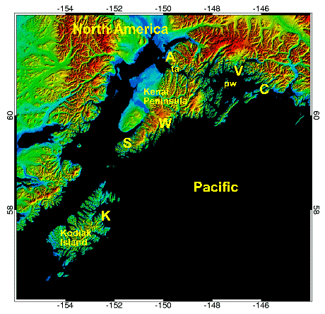
Figure 1: Topographic rendition of south central Alaska. Cities shown by letters are A=Anchorage, C=Cordova, K=Kodiak, S=Seldovia, V=Valdez, W=Seward. Also ta=Turnagain Arm and pw=Prince William Sound.
The available geodetic data is a rich mixture of space age and conventional observations. For the past decade Global Positioning System (GPS) studies of point positions have provided data used to derive estimates of horizontal and vertical crustal velocities. Areas of special concentration have included the Kenai Peninsula, nearby offshore locations, the greater Anchorage area, the Kodiak Island-Katmai region to the southwest, and near Valdez to the east. Prior to the availability of GPS, precision level surveys were undertaken to provide information on vertical motion. Repeated surveys were conducted along the Turnagain Arm, and single epoch measurements are available on the Kenai Peninsula. Tide gauge measurements have been made more or less continuously at a half dozen or more coastal sites. In a few cases, these measurements provide a time series extending back to before the 1964 earthquake. VLBI measurements were made in the late 1980’s on Kodiak Island and at a few other sites in Alaska. Recently, a continuously operating GPS station was installed near the tide gauge at Seldovia. Additional information about crustal movements come from a limited number of triangulation measurements, geological observations such as changes in the heights of algae and soil depositional changes, and from tsunami records.
Some of the most significant results from this wealth of data include:
(1) The postseismic uplift in the region that subsided during the earthquake was both rapid and large. Between Anchorage and the Kenai Peninsula the subsidence was as much 2 m during the earthquake. However, the cumulative uplift since the earthquake may exceed 1m in some locales (Figure 2). The most rapid uplift was right after the earthquake and may have been as much as 150 mm/yr. Leveling data from the Turnagain Arm suggests that postseismic creep occurred along the down-dip extension of the coseismic rupture plane in the first few years following the earthquake. On the other hand, decreases in the vertical displacement rate at tide gauges on Kodiak Island and Cordova reveal the existence of a much longer-lived transient phenomenon lasting on the order of 1-2 decades. Other tide gauge data suggest that an even longer lived postseismic process may also be at work.
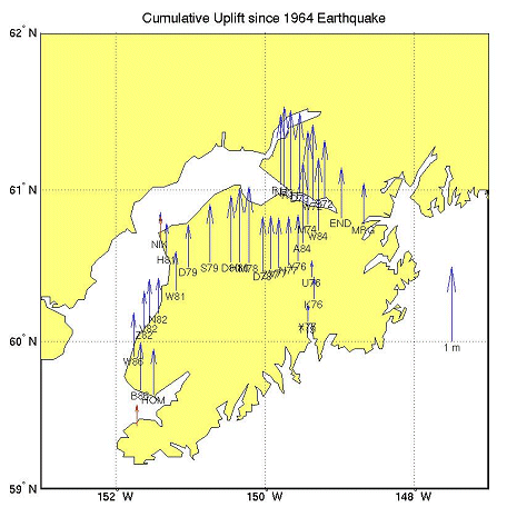
Figure 2. Uplift since 1964 on Kenai Peninsula and adjacent areas. The uplift is plotted relative to a tide gauge station at Seward. The red arrows show uplift as determined from tide gauge observations, the blue arrows show uplift determined by comparing post-earthquake leveling height observations to contemporary GPS vertical position determinations
(2) There is considerable along-strike (lateral) variability in the contemporary pattern of horizontal deformation. On the eastern Kenai Peninsula, the present-day velocities (relative to stable North America) are as large as 30-40 mm/yr. These are parallel to the direction of relative plate motion, decrease with distance from the plate boundary, and are largely consistent with standard models of strain accumulation along a strongly coupled plate interface. However in the western Kenai Peninsula, the velocities are directed SSW, i.e. generally in the opposite direction from those on the eastern side of the Peninsula, and have speeds on the order of 20 mm/yr. The pattern of crustal deformation is suggestive of a long-lived or delayed response to the 1964 earthquake, but does not allow for significant contemporary strain accumulation.
(3) There can be sudden changes in the deformation pattern even several decades after the earthquake. GPS measurements near Anchorage made prior to 1998 display a velocity pattern similar to those on the Kenai Peninsula and are indicative of strain accumulation. However, the velocities reversed after 1998 and it appears that a “slow earthquake”, with considerable slip, may well have occurred.
Taken as a whole, these observations suggest a complex pattern of plate boundary interactions where the coupling between the overriding and subduction plates not only varies with location but also with time. Thus the models of regional seismotectonics that are required today are much more sophisticated than the simple elastic-frictional or even viscoelastic-frictional models of just a few years ago. Researchers are now developing various numerical models of this crustal deformation that take into account both bulk rock properties and fault rheology, variations in the plate interface geometry, and both plate interface and crustal faulting. The “Advances in Geophysics” article is a comprehensive summary of both the observational information and modeling results from the southcentral Alaska region that will serve as a resource for investigators studying both the Alaskan as well as other subduction zones.
(Contact: Steven Cohen, Geodynamics Branch, Steven.C.Cohen@nasa.gov)
Comprehensive Field Modeling Paper Published (Terry Sabaka)
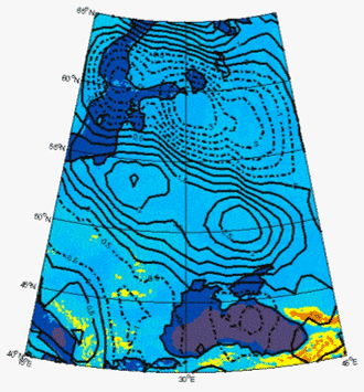
Ongoing improvements in the development of the GSFC Comprehensive Model reached a milestone with the recent publication of a major paper by Sabaka et al. (2002). This model, based on data from POGO, Magsat and ground-based observations, represents the state-of-the-art in main field models, and includes parameterized components for the external fields and the lithospheric fields as well as the core field. This same year has seen further refinements in comprehensive modeling (CM) efforts, led by Terry Sabaka, which were reported on at the 4th Oersted International Science Team meeting in Copenhagen, Denmark in September (see below). The latest improvements include additional data from the most recent magnetic mapping missions, the Danish Oersted and German CHAMP satellites. These push the time domain from an earlier 1960-1985 to a period covering 1960-mid 2002. In addition to extension of the main field secular variation model, a much lower noise lithospheric field was derived (Figure 1). In-situ currents through which Oersted flies are modeled in continuous diurnal time.
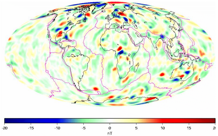
Figure 1. Lithospheric anomalies from the latest Comprehensive Model, including Oersted and CHAMP data. These have much less noise than in earlier models.
Goddard’s comprehensive models are now being used for a variety of applications. For example, the model will be used as the basis for removal of contamination from long-wavelength and diurnal variations in the planned USGS High Altitude Magnetic Mapping (HAMM) mission (an aeromagnetic survey). They have also being used by several research groups and in industry. Current and future programs using the Comprehensive Models include multi-satellite in-flight calibration efforts (Olsen et al., 2002) and mission simulation studies for the proposed SWARM (constellation) mission. Because of the increasing demand for these models, a website is being developed that will offer the latest models, codes and documentation. As part of this outreach effort, Sabaka has developed a versatile forward code available in ANSI Fortran, which computes magnetic and electric current density fields at positions in space and time, and also returns model coefficients in various forms.
REFERENCES
Olsen, N., L. Toffner-Clausen, T. Risbo, P. Brauer, J. Merayo, F. Primdahl and T. Sabaka, In-flight calibration methods used for the Oersted mission, Earth Planets and Space, 2002 (accepted).
Sabaka, T.J., N. Olsen and R.A. Langel, A comprehensive model of the quiet-time, near-Earth magnetic field: phase 3, Geophys. J. Int., 151, 32-68, 2002.
(Contact: Terry Sabaka, Geodynamics Branch, sabaka@geomag.gsfc.nasa.gov)
AGU Virtual Session Held (Michael Purucker)
In what may be a template for the future, AGU conducted a “virtual session” during its Spring Meeting, using a web-based protocol to bring together participants from around the world. Mike Purucker was one of the chief organizers of GP21A, which discussed analysis of selected, previously posted, data from the “mini-constellation” of magnetic field satellites Oersted, CHAMP and SAC-C. 27 authors and co-authors from 9 different countries were involved.
One of the main topics discussed was the apparently forced decay of the Earth’s dipolar field, which is occurring 10 times faster than would happen if the core dynamo (which generates the field) were
switched off completely. Growing patches of reversed polarity field are believed responsible; if these continue to grow they could lead to a new reversal of the Earth’s field as has occurred in the past.
In preparation for this unique event, 19 days of common satellite data were selected and posted on a dedicated web site, in order that different analysis methods could be applied to the same data. The community was alerted to the virtual session through e-mail with a link provided to the web site. A common HTML and JPEG template for presentation, which all but one presenter chose to use, was also provided. The data became available in January and February, and abstracts submitted and posted in March. Authors submitted their presentations in early May which were made available on the web site. The “live” session was actually held in 2-hour periods on May 28th and 29th.

Figure 1. Michael Purucker and 26 other authors from 9 countries engaged in a “virtual” session as part of the Spring 2002 AGU Meeting.
Following the actual “live” session, discussions were appended in June and a CD with papers and data was distributed to the authors. This follow-up is another unique aspect of the virtual session method of holding international meetings. A meeting report appeared in the August 20 issue of EOS (v.83, p. 368, 2002) in the “About AGU” section.
(Contact: Michael Purucker, Geodynamics Branch, purucker@geomag.gsfc.nasa.gov)
SWARM Constellation Selected by ESA (Michael Purucker)
In May of this year, ESA selected three new Earth Opportunity Mission candidates for possible launch in the 2007-2009 time frame. One of those missions, SWARM, is a multi-satellite mission designed to study the multitude of magnetic fields encountered in near-Earth space. Mike Purucker is one of several US co-investigators (3 are from GSFC) on the SWARM science team, and is the only US participant asked by ESA to serve on the Mission Advisory Group (MAG) during the 1.5 year Phase A Study period. At the end of this time a decision will be made as to whether or not SWARM continues on to launch. The main function of the MAG is to formulate the detailed scientific requirements for the new mission and to draft a Mission Requirements Document.
SWARM is to provide the best description yet of the Earth’s magnetic environment, including its particles, fields and currents, and how these change over time. These are important to our understanding of the interior of the Earth as well as the likely vulnerability of the Earth to periods of low magnetic field intensity. For example, it is now known than the Earth’s main field is decaying at a rate faster than would be expected even if the fluid motions in the core were suddenly switched off. This “forced decay” may be leading to a major reversal of the Earth’s field.
SWARM will provide important new knowledge of the expanding, deepening South Atlantic Anomaly, with its serious implications for low-Earth satellite operations. Geographically, the recent decay of the Earth's magnetic dipole is largely due to changes in the field in that region. The geomagnetic field models resulting from this mission will have practical applications in many different areas, such as space weather and radiation hazards understanding of atmospheric processes related to climate and weather.
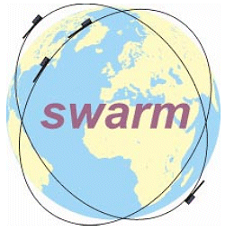

Figure 1. Left: SWARM logo. Right: Artist’s concept of the SWARM constellation.
The SWARM concept consists of a constellation of four satellites in two different polar orbits between 400 and 550 km altitude. Each satellite will provide high-precision and high-resolution measurements of the magnetic field. Together they will provide the necessary observations for the geomagnetic field that is needed to model its various sources.
(Contact: Michael Purucker, Geodynamics Branch, purucker@geomag.gsfc.nasa.gov)
Four Attend Oersted International Science Team Meeting (Purucker, Sabaka, Taylor, Voorhies)
 |
In a strong show of the strength of the Goddard program, four members of the Geodynamics Branch presented papers at the 4th Oersted International Science Team meeting in Copenhagen, Denmark on 23-27 September 2002. Pat Taylor (with co-authors Kim, Potts, von Frese and Frawley) gave a poster on “Satellite altitude geopotential study of the Kursk Anomaly (KMA)” and was a co-author on a paper by Kim, von Frese, Park and Taylor “Utility of satellite magnetic observations for estimating near surface magnetic anomalies”. Coerte Voorhies had a paper “Narrow scale, weak field flow at the top of Earth’s core: evidence from Oersted, Magsat and secular variation”. Mike Purucker presented along with Sabaka, Olsen and Maus his paper “How have Oersted, CHAMP, and SAC-C improved our knowledge of the oceanic regions?” Terry Sabaka chaired a session and also gave a paper with Olsen on the “Comprehensive Modeling of the Earth’s magnetic field: current status and future prospects”. A paper on the most recent field model was published this year (see above). In addition, Benoit Langlais, a post-doc from France working in the Geodynamics Branch, was a co-author on the paper by Hulot, Eymin, Langlais, Mandea and Olsen, “Small scale structure of the geodynamo inferred from Oersted and Magsat satellite data” which was presented by Hulot.
(Contact: Herbert Frey, Geodynamics Branch, Herbert.V.Frey@nasa.gov)
|
In order to constrain the possible origin of satellite altitude crustal magnetic anomalies, information of the magnetic properties of rocks from the likely source regions is needed. Magnetic properties of rocks from two different boreholes, the Kola superdeep borehole and Krivoy Rog deep borehole, have recently been compared. Highly magnetic serpentinized peridotites and sedimentary rocks affected by sulfide mineralization were recovered at the Kola borehole at a depth interval of 1540-1940 m. The Krivoy Rog borehole recovered highly magnetic iron quartzites of Banded Iron Formations at depths of 1853-2040 m. Extremely high values of remanent magnetization (NRM), magnetic susceptibility (K) and Konigsberger ratio (Qn) are found at approximately the same depths of about 2000 m from both boreholes. There is no obvious reason why high magnetizations should occur at the same depth in two boreholes with such different lithologies. Magnetic surveys and surface sampling in the nearby Krivoy Rog and Kursk Magnetic Anomaly areas have revealed iron quartzites with high magnetization, similar to values given here. AF demagnetization tests suggest that a magnetically hard and stable NRM component, likely caused by hematite, occurred in iron quartzites in different forms and grain sizes ranges.
The data for this study can be found on the Goddard Magnetic Petrology Database now being compiled at the Geodynamics Branch of NASA/Goddard Space Flight Center and published on the web at
http://core2.gsfc.nasa.gov/research/terr_mag/php/MPDB/frames.html
A paper on this work has been submitted to Earth and Planetary Science Letters.
(Contact: Katharine Nazarova, Geodynamics Branch, katianh@geomag.gsfc.nasa.gov)
Narrow-Scale Flow at Top of Earth’s Core (Coerte Voorhies)
In previously published work [Voorhies, 1993, 1995], slow changes of the geomagnetic field were fitted in terms of broad-scale fluid flow by the top of Earth’s liquid ferro-metallic outer core. These conditional core surface flow estimates indicate that the molten metal moves at about 8 km/yr. Analysis of magnetic changes from 1945 to 1980 revealed evidence for time-dependent flow by the top of the core, including a curious acceleration of fluid upwelling in an area 2900 km beneath Bermuda. If this acceleration had continued past 1980, the intense upwelling would tend to blow away magnetic field line footpoints, weakening the magnetic field in this region. As it turned out, the greatest change in geomagnetic field intensity here on Earth’s surface between the epoch 1980 Magsat mission and the epoch 2000 Oersted mission was the 2400 nT (5%) drop in intensity centered on Bermuda.
Further work on the spectra of the main geomagnetic field and of its slow secular variation has revealed some evidence for narrow scale flow across a dynamically weak field. To test this hypothesis against observation, the Ørsted Initial Field Model is used to estimate the radius of Earth’s core by spectral methods. The theoretical spectrum tested is obtained from the hypotheses of narrow scale flow across a dynamically weak magnetic field near the top of Earth’s core; it describes a low degree, core-source magnetic energy range. Core radius c and amplitude K are estimated by fitting log-theoretical to log-observational spectra at low degrees. Estimates of c for degrees 4 through 12 are 3441 to 3542 km, which do not differ significantly from the seismologic core radius (3480 km). Significant differences do occur if N exceeds 12, which is consistent with appreciable non-core source fields at degrees 13 and above (crustal fields). Similar results are obtained from the 1980 epoch Magsat model CM3. We also used an expectation spectrum for low degree secular variation (SV) induced by narrow scale flow by the top of the core. The value of c obtained by fitting this form to the mean observational SV spectrum from model GSFC 9/80 is 3470 + 91 km, also in accord with seismologic estimates. This test of the narrow scale flow hypothesis is independent of the weak field hypothesis.
The results were summarized at the 2002 meeting of the Oersted International Science Team and have been submitted to Journal of Geophysical Research in the paper “Narrow scale, weak field flow by the top of Earth’s core: Evidence from Magsat, Oersted, and secular variation”.
(Contact: Coerte Voorhies, Geodynamics Branch, Coerte.V.Voorhies@.nasa.gov)
Magsat, Oersted and CHAMP Data Compared (Patrick Taylor)
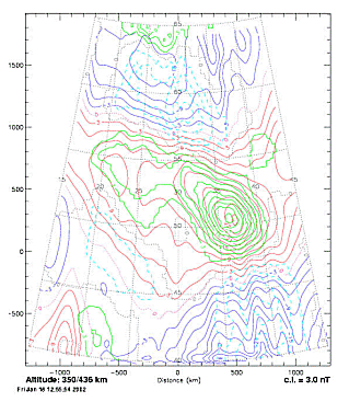
Crustal magnetic anomaly signals are far weaker than either the Earth's main magnetic dipole field or the omnipresent time-varying external fields. In order to establish that these small amplitude, time-invariant magnetic signatures truly represented crustal units and therefore are useful in regional geologic and tectonic studies, it is useful to make satellite magnetic anomaly maps over well known magnetic features. Alternatively, upward continued ground-based or aeromagnetic surveys can be compared with satellite data. When Magsat was launched in 1979, a satellite altitude (350 km) magnetic anomaly map over the well-known Kursk Magnetic Anomaly (KMA) region of Russia was produced by Taylor and Frawley (1987). The Kursk Magnetic Anomaly (KMA) (510 N, 370 E) has long been recognized as one of the largest magnetic anomalies on Earth. It is associated with massive quartz iron-ore formations (the largest known iron-ore deposits on Earth). In February 1999, the Øersted satellite was launched (Neubert et al., 2001) into a much higher orbit (850 by 613 km) than Magsat. It was assumed by some that crustal magnetic anomalies would not be resolved. Taylor et al. (2000) showed, however, there was a distinct and similar crustal magnetic signal recoverable from Oersted over this region (Figure 1). Following the launch of CHAMP into a circular 454 km orbit in July 2001, we used the initial data from this most recent mission to make yet another crustal anomaly map of the KMA (Figure 2).
|
|
|
|
Figure 1. Total field (scalar) magnetic anomaly map of Eastern Europe centered on the KMA and computed at 660 km altitude from the Øersted mission data. Contour interval is 0.5 nT with positive and negative values given by solid and dashed contours respectively (Taylor et al. 2000). |
Figure 2. Anomaly maps of Magsat and CHAMP data plotted together over the KMA. Magsat contours are in a gray shade and the CHAMP contours are bolder Contour interval is 3 nT with zero contour dotted and positive and negative values given by solid and dashed contours respectively. |
Figure 2 shows the superposition of both the Magsat and CHAMP magnetic anomaly maps. Note that these anomaly contours over the KMA are very similar, having a generally northwest-southeast trend across this region and mirroring the iron-ore formations. Differences between these anomaly fields are due to the greater number of orbit profiles from the CHAMP data set and different ranges of altitude and orbital eccentricities between these two satellites. Both the currently operating Øersted and CHAMP geopotential satellites are able to record magnetic anomalies from sources within the Earth's crust and therefore can be used for geologic and tectonic studies. CHAMP is also recording the gravity field, therefore in future studies we will be able to incorporate the magnetic measurements with these gravity data to add another parameter to aid in our modeling of the crustal features of the Earth.
[Report taken from: P. Taylor, H. Kim, R. von Frese, L. Potts and J. Frawley, Satellite-Altitude Geopotential Study of the Kursk Magnetic Anomaly (KMA), First CHAMP Mission Results for Gravity, Magnetic and Atmospheric Studies, edited by Ch. Reigber, H. Luehr and P. Schwintzer, Springer-Verlag, Heidelberg, in press, 2003]
REFERENCES
Neubert, T. et al. (2001): Øersted Satellite Captures High-Precision Geomagnetic Field Data, Eos, Transactions, American Geophysical Union, 82, 81 and 87-88.
Taylor, P. T. and J. J. Frawley (1987): Magsat anomaly data over the Kursk region, USSR, Phys. Earth Planet. Interiors, 45, 5-15.
Taylor, P.T., R.R.B. von Frese and H. R. Kim (2000): Ørsted and Magsat: A comparison over the Kursk magnetic anomaly, Proceedings, 3rd Internantional Science Meeting, Grasse, France
(Contact: Patrick Taylor, Geodynamics Branch, Patrick.T.Taylorr@nasa.gov)
TOPOGRAPHY AND SURFACE CHANGE
Puget Sound Lidar Studies (David Harding)
Surface deformation caused by large earthquakes often produces geomorphic features that provide significant constraints on fault locations, sense of motion, and displacement magnitudes. David Harding, a participant in the Puget Sound Lidar Consortium (http://www.pugetsoundlidar.org), is using very high resolution digital elevation data in the Puget Lowland of Washington State to characterize deformation caused by Holocene earthquakes. The elevation data was acquired by airborne laser mapping, a technique that reveals the ground topography beneath the dense temperate rain forest cover of the Pacific Northwest.
At invited talks this year at the Geological Society of America Cordilleran Section annual meeting, the Spring American Geophysical Union meeting, and the Geological Society of Washington, Harding reported on results that define spatial patterns of fault slip that occurred circa A.D. 900 in the Seattle fault zone. This slip was due to a magnitude 7 (or greater) earthquake. Harding used the laser mapping data to measure the elevation of shoreline angles at the landward edge of uplifted and tilted terraces that border Puget Sound (Figure 1). A shoreline angle is a paleo-horizontal marker originally formed at sea level by wave-cut erosion. The terraces define a broad, 5 km wide, asymmetric anticline across the width of the Seattle fault zone, formed by slip on the most northerly, basal thrust.

Figure 1. An example of terrace shoreline angle elevation profiles (lower right) measured from laser mapping elevation data (lower left) that reveals the ground topography beneath dense vegetation (the north-south ridges are the result of glacial erosion). The terrace was uplifted by as much as 10 m, tilted to the south, and offset by fault scarps during the A.D. 900 earthquake.
Terrace offsets on the south limb of the anticline indicate that structural higher thrusts also underwent slip during the earthquake. This study documents that multiple fault strands within the Seattle fault zone are still active and constrains their magnitude and sense of slip during the A.D. 900 earthquake. These results contribute to an improved assessment of the earthquake hazard in the densely populated Puget Sound region.
(Contact: David Harding, Geodynamics Branch, David.J.Harding@.nasa.gov)
Biomass Measurements from Lidar Mapping (David Harding)
In addition to providing a method to measure topography beneath vegetation cover, laser altimetry enables measurements of forest canopies that cannot be achieved by other remote sensing techniques. David Harding and collaborators at Oregon State University, the USDA Forest Service Pacific NW Research Station, and the Smithsonian Environmental Research Center, have published a series of articles that document this capability. Using field observations of forest properties and data acquired by the airborne Scanning Lidar Imager of Canopies by Echo Recovery (SLICER), methods were developed to predict forest attributes from the laser backscatter signal. As a first step, two properties of forest canopies important to ecosystem function are obtained from the backscatter signal: vertical transmittance of light (Parker et al., 2001) and height distribution of plant area (Harding et al., 2001).
Height indices derived from the plant area distributions have previously been shown to be an accurate predicator of above ground forest biomass for specific forest types (reviewed in Lefsky et al., 2002a). Lefsky et al (2002b) show that a single predictive relationship is equally applicable to three different closed-canopy forest biomes: temperate deciduous, temperate coniferous, and boreal coniferous (Figure 1). Based on regression of height indices and field observations of above ground biomass, mean height of the canopy squared (a proxy for height x stem diameter; a measure of volume) is the best laser-based predictor. The relationship is linear to high biomass levels, and accounts for the observed variance to a high degree (80% to 90%). The generality of this result, at least for these three biomes, suggests that laser backscatter data for closed-canopy forests can be used to predict biomass without knowing the specific forest cover type sampled. The forest canopy measurement capabilities developed using airborne SLICER data will be applied on a global basis to laser altimeter data acquired by the Ice, Cloud and Land Elevation Satellite (ICESat).
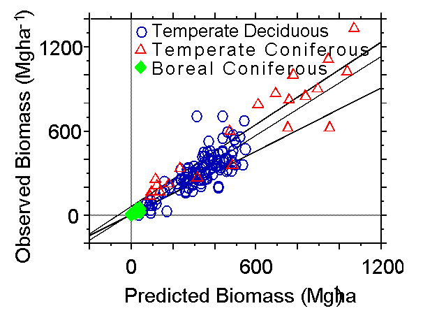
Figure 1. Relationship for three forest biomes between observed biomass and that predicted from laser backscatter height indices.
REFERENCES:
Harding, D.J., M.A. Lefsky, G.G. Parker, and J.B. Blair, Laser altimeter canopy height profiles: Methods and validation for deciduous, broadleaf forests, Remote Sensing of Environment, 76(3): 283-297, 2001.
Lefsky, M.A., W.B. Cohen, G.G. Parker, and D.J. Harding, Lidar remote sensing for ecosystem studies, Biosciences, 52(1), 19-30, 2002a.
Lefsky, M.A., W.B. Cohen, D.J. Harding, G.G. Parker, S.A. Acker, and S.T. Gower, Lidar remote sensing of aboveground biomass in three biomes, Global Ecology and Biogeography, 11(5): 393-399, 2002b.
Parker, G.G., M.A. Lefsky, and D.J. Harding, Light transmittance in forest canopies determined using airborne laser altimetry and in-canopy quantum measurements, Remote Sensing of Environment, 76(3): 298-309, 2001.
(Contact: David Harding, Geodynamics Branch, David.J.Harding@nasa.gov)
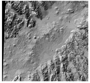
Basaltic plains style volcanism is a common form of volcanic planetary resurfacing, and is thought to be a significant factor in the volcanic and thermal histories of all of the terrestrial planets (Earth, Moon, Mercury, Mars, and Venus, as well as some of the larger satellites of the gas giant planets). Plains volcanism is well illustrated on Earth, with perhaps the textbook example being the Eastern Snake River Plains (ESRP) of Idaho. Volcanic features in the ESRP have erupted through several hundred separate vents, and are characterized by a mix of rift eruptions, low shields that often coalesce, a few cinder cones, and extensive fields of relatively thin lava flows commonly slowly emplaced through systems of channels and lava tubes over rather low regional slopes. The total thickness of the sequence is thought to be a few km, erupted over about 15 million years, with the most recent eruptions within the last few thousand years, and future eruptions possible at wide time intervals.
|
|
|
Figure 1. Shaded relief topography for the Syria region of Mars (left) and the Eastern Snake River Plains region of Idaho (right). Both regions show basaltic plains volcanism features, including low shields, flow fields, lava tubes, and rift eruptions.
While this style of volcanism is well known, it is not yet well understood or quantified even though it is important for our understanding of regional terrestrial resurfacing rates, volcanic hazards, and tectonic-volcanic systems relationships. Susan Sakimoto and colleagues Tracy Gregg (SUNY, Buffalo) and Scott Hughes (Idaho State) are engaged in a study which combines existing remote sensing measurements with higher accuracy field measurements and ground truth to understand the topography and petrology of the ESRP system, and to use that data to constrain eruption types and rates. In parallel with the terrestrial measurement effort, they are characterizing similar regions on Mars, with the expectation that terrestrial results will be directly applicable to the similar martian rate and eruption style questions. The work is in collaboration with the Idaho Space Grant, and is funded through both the NASA Space Grant EPSCoR 2000 program and through the NASA Mars Data Analysis Program.
This summer, the field season in the ESRP was focused on using GPS receivers to characterize topography profiles across the summit regions of the low volcanic shields as well as across some of the tube and channel fed volcanic flows. The summit regions show some systematic differences in topography that appear to be correlated with the petrology (texture and composition) of the lavas. This may be a direct reflection of the chemical evolution of the contributing magma chamber (e.g. Hughes, et al., 1999, 2001, 2002a, 2002b). The field data combined with remote spectral and topographic data and laboratory compositional and petrological work suggests that the steeper summit regions on many of the basaltic shields are very likely an expression of the slightly more evolved petrology for these shields, and in some cases are diagnostic of the extent of local ground water involvement in the eruption process. The parallel work on the topography of the martian volcanic fields (e.g. Sakimoto et al., 2001, 2002a, 2002b) shows a similar range of summit topography variations for the small shield volcanoes. It is expected that the terrestrial results will help us understand the contributions of local water availability and compositional evolution to topography in the ESRP. It should also have direct applicability to constraining similar questions on the chemical evolution and local water availability for our analogous martian plains volcanism regimes.
These results were presented in a set of paired at the 2002 Fall Geological Society of America meeting in Denver in the session T90. Terrestrial Approaches to Extraterrestrial Problems and Vice Versa. (Sakimoto et al., 2002b, Hughes et al., 2002b).
REFERENCES:
Hughes, S. S., M. McCurry, et al.. Geochemical correlations and implications for the magmatic evolution of basalt flow groups at the INEEL. Geology, Hydrogeology and Environmental Remediation, Idaho National Engineering and Environmental Laboratory. P. K. Link and L. L. Mink, Geol. Soc. of Am. Special Paper 353, 2002a.
Hughes, S.S., S.E.H. Sakimoto, and T.K.P. Gregg,Plains volcanism in the Eastern Snake River Plain: Quantitative measurements of petrologic contributions to topography with comparisons to Mars, GSA Annual Meeting Abstracts, Paper #77-3, 2002b.
Hughes S.S., R.P. Smith, W.R. Hackett, and S.R. Anderson Mafic volcanism and environmental geology of the eastern Snake River Plain, in Hughes, S.S., and Thackray, G.D., eds., Guidebook to the Geology of Eastern Idaho: Idaho Museum of Natural History, p. 143-168, 1999.
Hughes S.S., P.H. Wetmore, and J.L. Casper Evolution of Quaternary tholeiitic basalt eruptive centers on the eastern Snake River Plain, Idaho, in Bonnichsen, B., White, C., and McCurry M., eds., Tectonic and magmatic evolution of the Snake River Plain volcanic province: Idaho Geological Survey Special Publication, 2000.
Sakimoto, S.E.H., J.B. Garvin, B.A. Bradley, M. Wong, and J.J. Frawley, Small martian north polar volcanoes: Topographic implications for eruption styles, LPSC XXXII, CDROM, abstract #1808, 2001.
Sakimoto, S.E.H., D. Mitchell, S.J. Reidel, and K. Taylor, Small Shield Volcanoes on Mars: Global Geometric Properties and Model Implications for Regional Variations in Eruptive Styles, LPSC XXXIII, CDROM, abstract #1717, 2002.
Sakimoto, S.E.H., S.S. Hughes, T.K.P. Gregg, Plains volcanism on Mars: Topographic data on shield and flow distributions and abundances, with new quantitative comparisons to the Snake River Plain Volcanic Provinces, GSA Annual Meeting Abstracts, Paper #77-2, 2002b.
(Contact: Susan Sakimoto, Geodynamics Branch, sakimoto@core2.gsfc.nasa.gov)
PLANETARY GEOLOGY AND GEOPHYSICS
Recent Studies of Mars Magnetic Anomalies (Mike Purucker)
Why are some martian terranes strongly magnetic and some non-magnetic? In a talk at the 33rd Lunar and Planetary Science Conference, Mike Purucker discussed the origin of a terrane, centered at Noachis Terra in the southern highlands, that has no strong magnitude magnetic fields (anomaoies) associated with it, unlike that of nearby terranes. This is enigmatic because the age of the rocks at the surface in the non-magnetic region is not much different from those in the adjacent, strongly magnetic region. Parts of this non-magnetic region are associated with the Argyre and Hellas impact basins, but one or more additional large impacts or thermal events may be necessary to produce such a region absent large-scale fields. Some candidates were suggested based on MOLA topographic data which is useful for revealing even subtle depressions or basins.
As part of a popular presentation to a technical audience of non-specialists at the Society of Exploration Geophysicists, Purucker reviewed the state of knowledge on possible mineral resources on Mars. In a presentation called “Exploration Geophysics on Mars: A tale of Minerals and Water”, he also suggested the presence of deep concentrations of iron in the Terra Cimmeria and Sirenum regions, and the possible presence of near-surface Cu-Fe sulfides in the Apollinaris Patera region. An online version of the talk is available at
geodynamics.gsfc.nasa.gov/research/purucker/mag_gravity_luncheon.html
and a version is being prepared for publication in 'The Leading Edge'.
(Contact: Michael Purucker, Geodynamics Branch, purucker@geomag.gsfc.nasa.gov)
Buried Basins on Mars (Herbert Frey)
MOLA data has revealed an abundance of Quasi-Circular Depressions (QCDs) on Mars which have little or no expression in image data. These are most likely buried impact basins, covered versions of the impacts exposed at the surface. An earlier study of more than 600 of these in the lowlands of Mars showed that the crust below the young, smooth plains was as old and likely older than the exposed cratered highlands (Frey et al., 2002). In a paper given at the 2002 Lunar and Planetary Science Conference, Herb Frey showed that these buried lowland basins constrain the lowlands in eastern Mars to have formed in the earliest part of the Early Noachian, the oldest period of martian history (Frey, H., 2002). Further, in at least this part of Mars, the lowlands formed as the result of a giant impact. Though first suggested by George McGill in 1989 to be a giant impact, the Utopia Basin was not universally accepted as a larger version of Hellas or Argyre until MOLA topography showed its full bowl-like shape. Like the rest of the lowlands of Mars, this area has a large number of buried basins superimposed on it (Figure 1). These were shown by Frey and co-workers to be of Early Noachian age, meaning the Utopia impact which must pre-date these smaller basins is even older. Since the impact produced the low topography characteristic of this region (and since that imprint has remained intact since the impact), the crustal dichotomy in eastern Mars must date from essentially the earliest part of recorded martian history. Processes other than impact appear to have had little role to play in at least this part of Mars.
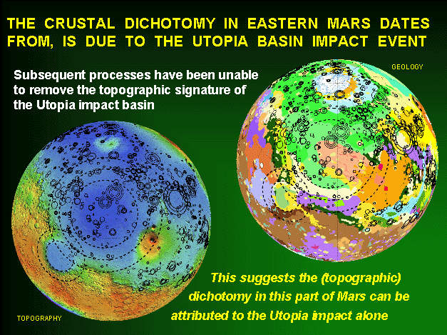
Figure 1: MOLA topography (lower left) and global geology (upper right) with lowland QCDs (mostly buried impact basins) superimposed on it. The large multi-ring structure is the Utopia impact basin, which is overlapped by the Isidis impact basin on its SW side. From Frey, H. 2002.
Buried basins elsewhere on Mars have also provided evidence for crust older than the Early Noachian. In what started as a science fair project, sophomore Erin Frey of South River High School, working with her father Herb Frey, found clear evidence for QCDs not visible on images in the oldest and most heavily cratered parts of Mars (Frey and Frey, 2002; Frey, E. et al., 2002). The region to the SE of the ancient Hellas impact basin, about 1.2 million sq km, is mapped as Early Noachian, based on its rugged nature and high density of craters. E. Frey found that there was a significant population of buried basins in this area, which implies a crust below that is older than the surface. The total crater cumulative crater density is about 1.6 times that of the visible crater density. These results were presented at the Spring AGU Meeting in Washington by E. Frey (Frey and Frey, 2002) in her first professional paper. H. Frey did a similar study in the other major outcrop of Early Noachian terrain near the slightly younger (but still Early Noachian-age) Isidis impact basin and found similar evidence for an even larger population of buried basins (Frey, E. et al., 2002). Thus it appears what is mapped as Early Noachian material is not primordial crust on Mars dating back to 4.6 billion years ago. Curiously, in both the Hellas and Isidis areas the total crater density, the buried and visible populations together, are nearly the same. They are also very similar to the total crater density for several other Noachian areas (Figure 2).
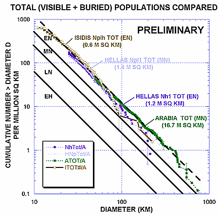
Figure 2: Total (visible + buried) cumulative frequency curves for several Noachian terrains, including a large area in Arabia and areas near the Hellas and Isidis impact basins. Note that all of these seem to show a similar crater retention age. From Frey, E. et al., 2002. on it. The large multi-ring structure is the Utopia impact basin, which is overlapped by the Isidis impact basin on its SW side. From Frey, H. 2002.
Similar total (visible + buried) crater retention ages for a number of different old units at different places around Mars could be due to crater saturation and might be a limit beyond which we cannot see and cannot date (in terms of impact craters) the buried surfaces. Alternatively, the similar crater retention age could represent a common early crustal age, perhaps of the original crust on Mars.
This work was presented at the Geological Society of America Meeting in Denver, CO (Frey, E., et al., 2002).
REFERENCES:
Frey, E. L. and H. V. Frey, Evidence for an Earlier Early Noachian on Mars, Spring AGU Paper P32A-01, 2002.
Frey, E.L., H. V. Frey, W. K. Hartmann and K. L. Tanaka, Evidence for Crust Older than the Oldest Surface Units on Mars, GSA Annual Fall Meeting, Paper 26-2, 2002.
Frey H.V. Age and Origin of the Crustal Dichotomy in Eastern Mars, Lunar Planet Sci. Conf. XXXIII, abstract 1680, 2002.
Frey, H.V., J. H. Roark, K. M. Shockey, E. L. Frey and S. E. H. Sakimoto, Ancient Lowlands on Mars, Geophys. Res. Lett. 29, 10.1029/2001GL013832, 2002.
(Contact: Herbert Frey, Geodynamics Branch, Herbert.V.Frey@nasa.gov)
ORBITAL – ROTATIONAL – CLIMATIC INTERACTION
Orbital Noise and Climate Fluctuation (Han-Shou Liu)
The current debate on the Earth’s climate fluctuations, (such as Global Warming) is driven by the observation of atmospheric concentrations of the greenhouse gases (CO2 and CH4). Popular climate models contain high levels of atmospheric carbon dioxide and predict that global greenhouse warming would cause heating in the tropics, but historical fossil isotopic data have indicated cool tropical temperature during greenhouse episodes. This mismatch between observation data and the climate models, known as the cool-tropic paradox, implies that either the data are flawed or there is still a lot to understand about feedback mechanisms in climate models.
Han-Shou Liu and co-workers (Liu, et al., 2002) suggest, from a dynamics point of view, that the common cause of climate and greenhouse-gas fluctuations is the orbital noise in the Earth’s system which is distinct from the commonly considered orbital signals in eccentricity and precession. This finding provides a link between orbital noise and climate fluctuations for climate studies. Figure 1 shows calculations of insolation pulsation induced by orbital noise of the Earth’s changing obliquity.
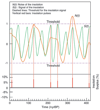
Figure 1. Noise-signal coupling effect on Rubincam’s (1994) orbital insolation induces pulsation in the incoming solar radiation. The threshold model is derived from the signal to noise mode The threshold (two horizontal dashed lines ) defines the maximum and minimum values of the insolation signal. Time is in kilo-years (kyr) before present (BP).
Global greenhouse warming phenomena during the past half million years were the effect and consequence of rapid temperature increases caused by insolation pulsation (Figure 2). In addition, Liu finds that the intensity of the insolation pulsation is dependent on the latitude. At high latitude, it provides extreme climate warming conditions for greenhouse-gas concentration. However, it decreases markedly in low-latitude regions, predicting cool tropical temperature during supposed greenhouse episodes.

Figure 2. Orbital insolation pulses cause atmospheric concentrations of carbon dioxide and methane and glacial- interglacial temperature changes .
REFERENCE:
Liu, H.S., R.Kolenkiewicz, and C. Wade, Orbital noise in the Earth system is a common cause of climate and greenhouse-gas fluctuation, Fluctuation and Noise Letters,Vol..2, No.2, 103-110, 2002.
Rubincam, D.P., Insolation in terms of the Earth’s orbital parameters, Theor. Applied Climatol. 48, 195-202, 1994.
(Contact: Han Shou Liu, Geodynamics Branch, hanshou@core2.gsfc.nasa.gov)
A Spin-Up for Asteroid 951 Gaspra? (Dave Rubincam)
Gaspra, the first asteroid ever to be photographed up close by a spacecraft, is a small body only 6 km in radius, rotating with a 7 hour period, and orbiting in the asteroid belt at 2.2 AU from the Sun. Gaspra's axial precession period turns out to be nearly commensurate with its orbital precession period. This leads to a resonance condition with huge variations in obliquity (obliquity being the tilt of Gaspra”s equator with respect to its orbital plane). How did the asteroid get into this resonance? One way is for the orbit to change over time. However, computing its orbit for the last 3 million years indicates its orbit is highly stable (see Figure 1).
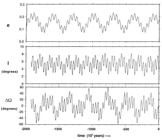
Figure 1. Evolution of the orbit of Gaspra over the last two million years. A more likely explanation is the YORP effect (Rubincam et al., 2002). YORP stands for Yarkovsky-O'Keefe-Radzievskii-Paddack. In the YORP effect, Gaspra absorbs sunlight and re-radiates it mostly as heat in the infrared. The infrared photons leaving the surface carry away momentum. By action-reaction, the asteroid receives a slight kick in the opposite direction. It is here the highly shape of Gaspara, known from photographs to be highly irregular, come into play. As shown in Figure 2, the re-radiation causes a net torque on the asteroid, making it spin faster. A change in the spin rate causes the obliquity to change.

Figure 2. Change in spin and change in obliquity for Gaspra.
It may be that Gaspra started out in a nonresonant state, but evolved into the resonance due to the YORP effect, and has been temporarily trapped there ever since. YORP can alter the spin of small asteroids like Gaspra over hundreds of millions of years, making it competitive with collisions in this regard. Thus YORP may be a major mechanism for altering the spin states of small asteroids and meteorites.
These results were published in the September 2002 issue of Journal of Geophysical Research: Planets.
REFERENCES:
Rubincam, D. P., D. D. Rowlands, and R. D. Ray, Is asteroid 921 Gaspra in a resonant obliquity state with its spin increasing due to YORP?, J. Geophys. Res., 107, 5065, doi:10.1029/2001JE001813, 2002.
(Contact: David Rubincam, Geodynamics Branch, David.P.Rubincam@nasa.gov)
EDUCATION AND OUTREACH
John Keller of the Astrochemistry Branch (Code 69) makes plastic models of spacecraft parts - and planetary surface features. The same plastic extrusion device obtained to support mission development work can be used to make 3-dimensional models of volcanoes, river valleys, impact craters and other features, provided a really good topography data set exists. MOLA (Mars Orbiting Laser Altimeter) has provided such data for Mars and comparable data exists for many parts of the Earth. So it is possible to make high accuracy topographic maps of surface features of interest. Figure 1 shows such view for the large Valles Marineris rift canyons of Mars compared to the East African Rift Valleys on Earth, and the largest volcano on Mars compared with the Hawaiian Islands. But flat views, even in perspective, do not fully convey the volumetric aspects of such objects. This is where models, like those of volcanoes at the right, can be useful.

Figure 1. Topographic renditions of the Valles Marineris rift canyons on Mars (upper left) compared to the East African rift Valley systems on Earth (lower left) at the same spatial scale and with the same topographic scale. The martian canyons are much, much deeper. On the right are compared the largest volcano on Mars, Olympus Mons, with the Hawaiian Islands of the Earth.
“Exploring Planetary Topography in the Classroom Using 3-Dimensional Models” is the title of a Director’s Discretionary Fund proposal recently won by Keller and four 921 co-investigators. Susan Sakimoto, Stephanie Stockman, Jim Roark and Herb Frey provided expertise in Earth and Mars geology, use of MOLA and Earth-based topographic data, and educational outreach using planetary analogs. Keller generated a number of example models for display at both the DDF presentation and at the Fall Geological Society of America (GSA) meeting. Figure 2 shows one such set of models, for the volcano comparison between Olympus Mons (Mars) and the Hawaiian Islands on the Earth, as shown in Figure 1. The vertical exaggeration is the same for both models, in this case, 7x the horizontal scale. The huge volume of Olympus Mons is greater than the volume of the Hawaiian Islands combined.
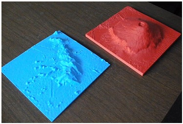
Figure 2. Models of volcanoes on Earth (Hawaiian Islands in blue, lower left) and on Mars (Olympus Mons, in red, upper right). The models have the same spatial scale and same vertical exaggeration (here, 7x horizontal). Each is about 8 inches on a side.
The DDF proposal is to develop teacher kits and lesson plans around comparative features on the two planets. These will include volcanoes, rift canyons, large river systems, polar caps, and other structures which permit discussion of the measurement and use of topographic data in understanding geologic processes, and how those process can be similar or different on different planets. The models and lesson plans will be tested out in classrooms by teachers in Sakimoto’s course “Teaching the Solar System” in the Spring at Johns Hopkins University.
The models were displayed at the Fall meeting of the Geological Society of America Meeting (GSA) by the Planetary Geology Division, of which Sakimoto is president. At the GSA a visually impaired undergraduate took advantage of the models (Below).
|
|
|
(Contact: Herbert Frey, Geodynamics Branch, Herbert.V.Frey@nasa.gov) .
.
PUBLICATIONS AND PRESENTATIONS
Bills, B.G., T.J. Wambeam, and D.R. Currey, Geodynamics of Lake Bonneville, in Great Salt Lake: An Overview of Change, pp 7-32, Utah Dept. Natural Resources, edited by J. Wallace Gwynn, 2002.
Cohen, S.C. and D.J. Darby, Tectonic plate coupling and elastic thickness derived from the inversion of geodetic data using a steady-state viscoelastic model: Application to southern North Island, New Zealand, J. Geophys. Res., 2001JB01687, 2002.
Zweck, C., J. T. Freymueller, and S .C. Cohen, Three dimensional elastic dislocation modeling of the postseismic response to the 1964 Alaska Earthquake, J. Geophys. Res., 107(B4), 10.1029/ 2001JB00409, 2002.
Zweck, C., J. T. Freymueller, and S. C. Cohen, The 1964 Great Alaska earthquake; present day and cumulative postseismic deformation in the western Kenai Peninsula, Phys. Earth Planet. Int., 132, 5-20, 2002.
Frey, H.V., J. H. Roark, K. M. Shockey, E. L. Frey and S. E. H. Sakimoto, Ancient lowlands on Mars, Geophys. Res. Lett. 29, 10.1029/2001GL013832, 2002.
Lefsky, M.A., W.B. Cohen, D.J. Harding, G.G. Parker, S.A. Acker, and S.T. Gower, Lidar remote sensing of aboveground biomass in three biomes, Global Ecology and Biogeography, 11(5): 393-399, 2002.
Lefsky, M.A., W.B. Cohen, G.G. Parker, and D.J. Harding, Lidar remote sensing for ecosystem studies, Biosciences, 52(1), 19-30, 2002.
Zwally, H.J., R. Schutz, W. Abdalati, J. Abshire, C. Bentley, J. Bufton, D. Harding, T. Herring, B. Minster, J. Spinhirne and R. Thomas, ICESat's laser measurements of polar ice, atmosphere, ocean, and land, Journal of Geodynamics, 34(3-4), 405-445, 2002.
Hulot G., C. Eymin, B. Langlais, M. Mandea, and N. Olsen, Small-scale structure of the geodynamo inferred from Øersted and MAGSAT satellite data, Nature, 416, pp. 620-623, 2002 International Conferences.
Liu , H.S., Kolenkiewicz, R., and Wade, C., Orbital noise in the Earth system is a common cause of climate and greenhouse-gas fluctuation, Fluctuation and Noise Letters, ( book and journal ), World Scientific, pp103-110, 2002.
Lowman, P. D., "Exploring Space, Exploring Earth: New Understanding of the Earth from Space Research," Cambridge University Press, 362 p., 2002.
Lowman, P. D., "Exploration Science: A Case History from Earth Orbit," P.D. Lowman, The Science Teacher, v. 69, no. 7, p. 24-30, 2002.
Purucker, M., B. Langlais, N. Olsen, G. Hulot, and M. Mandea, The southern edge of cratonic North America: Evidence from new satellite magnetometer observations, Geophys. Res. Lett., 29, 1 August 2002. (and the cover of the issue).
Purucker, M., H. McCreadie, S. Vennerstroem, G. Hulot, N. Olsen, H.Luehr, and E. Garnero, Highlights from AGU's Virtual session on new magnetic field satellites, EOS, 83, 368, August 20, 2002 (with associated CD-ROM).
Luhmann, J.G., M.H. Acuna, M. Purucker, C.T. Russell, and J.G.Lyon, The martian magnetosheath: how Venus-like?, Planetary and Space Science, 50, 489-502, 2002.
Rubincam, D. P., D. D. Rowlands, and R. D. Ray, Is asteroid 921 Gaspra in a resonant obliquity state with its spin increasing due to YORP?, J. Geophys. Res., 107, 5065, doi:10.1029/2001JE001813, 2002.
Ravat, D., K. Whaler, M. Pilkington, T. Sabaka and M. Purucker, Compatibility of high-altitude aeromagnetic and satellite-altitude magnetic anomalies over Canada, Geophysics, 67, 546-554, 2002.
Olsen, N., L. Toffner-Clausen, T. Risbo, P. Brauer, J. Merayo, F. Primdahl and T. Sabaka, In-flight calibration methods used for the Oersted mission, Earth Planets and Space, 2002 (accepted).
Sabaka, T.J., N. Olsen and R.A. Langel, A comprehensive model of the quiet-time, near-Earth magnetic field: phase 3, Geophys. J. Int., 151, 32-68, 2002.
Burr, D.M., A.s. McEwen and S.E.H. Sakimoto, Recent aqueous floods from the Cerberus Rupes, Mars, Geophys. Res. Lett. 29(1), 10.1029/2001GL013345, 2002.
Bradley, B.A., S.E.H. Sakimoto, H. Frey, J.r. Zimbelman, The Medusae Fossae Formation, Mars: new views from Mars Global Surveyor, J. Geophys. Res. (Planets),
von Frese, R.R.B., P. T. Taylor and M. Chiappini, Guest Editors, Magnetic anomalies of the Antarctic-Special Issue, Tectonophysics, vol. 347, Issues 1-3, 187 pp, March 2002.
Friis-Christensen, E., P. T. Taylor and K. Hinz Ilk, Guest Editors, Earth’s gravity and magnetic fields from space, Journal of Geodynamics-Special Issue, vol. 33, No. 1-2, 198 pp, January/March 2002.
Kim, H. R., R. R. B. von Frese, J. W. Kim, P. T. Taylor and T. Neubert, Øersted verifies regional magnetic anomalies of the Antarctic lithosphere, Geophysical Research Letters, vol. 29, no. 15, p. 3-1-3-3, 2002.
Ravat, D., B. Wang, E. Wildermuth and P. T. Taylor, Gradients in the interpretation of satellite-altitude magnetic data: an example from central Africa, Journal of Geodynamics, vol. 33 no. 1-2, p.131-142, 2002.
Kletetschka, G., P. J. Wasilewski and P. T. Taylor, The role of hematite-limonite solid solution in the production of magnetic anomalies in ground- and satellite-based data, Tectonophysics, vol. 347 no. 1-2, p. 167-178, 2002.
Voorhies, C.V., T.J. Sabaka, and M. Purucker, On magnetic spectra of Earth and Mars, J. Geophys. Res., 10.1029/2001/JE001534, 04 June 2002.
*********************************************************************************************
ACCEPTED:
Heirtzler, J.R. and K. Nazarova, Geomagnetic Secular Variation in the Indian Ocean, Earth Planet. Sci. Lett., 2002 (in press).
Langlais B., M. Mandea, and P. Ultré-Guérard, High-resolution magnetic field modeling: application to MAGSAT and Ørsted data, Phys. Earth Planet. Int., (in press).
Mandea M., and B. Langlais, Observatory crustal magnetic biases during MAGSAT and Ørsted satellite missions, Geophys. Res. Lett., (in press).
Liu, H.S., Kolenkiewicz,R., and Wade, C., Orbital noise of the Earth causes intensity fluctuation in the geomagnetic field, Fluctuation and Noise Letters, (in press) 2002.
Liu, H.S., Kolenkiewicz, R., and Wade, C., Insolation pulsation theory for atmospheric greenhouse-gas concentrations, Recent Research Development in Atmospheric Science (in press) 2002.
Liu, H.S., Satellite detection of stresses in the Earth, Recent Research Development in Geophysics, ( in press ) 2002.
Purucker M. E., B. Langlais, N. Olsen, G. Hulot, and M. Mandea, The southern edge of cratonic North America: evidence from new satellite magnetometer observations, Geophys. Res. Lett., 2002 (in press).
Ravat, D. and M. Purucker, Unraveling the magnetic mystery of the Earth's lithosphere: The background and role of the CHAMP mission, for CHAMP first science meeting results, Springer-Verlag,February, 2002 (in press).
Purucker, M. and N. Olsen, Improving the definition of cratonic boundaries utilizing the lithospheric magnetic field derived from CHAMP observations, for CHAMP first science meeting results, Springer-Verlag, 2002 (in press).
Bottke, W. F., D. Vokrouhlicky, D. P. Rubincam, Dynamical evolution of asteroids and meteoroids using the Yarkovksy effect, in ASTEROIDS III, in press, 2002.
Taylor, P.T., , J.J. Frawley, H.R. Kim, R, von Frese and J.W. Kim, Comparing Magsat, Øersted and CHAMP crustal magnetic anomaly data over the Kursk Magnetic Anomaly, Russia, CHAMP Science Team Meeting, First Meeting, Springer, February 2003.
Taylor, P.T. and J.J. Frawley, Satellite-Altitude-Magnetic Data and the Search for Mineral Resources: the Kiruna region of Sweden, Global Tectonics and Metallogeny, (in press) vol. 8, no. 1-4, 2003.
Kutina, J. and P. T. Taylor, Satellite altitude magnetic anomalies-implications for mineral exploration: A review, Global Tectonics and Metallogeny, (in press) vol. 8, no. 1-4, 2002.
Taylor, P.T., H.R. Kim, R. R.B. von Frese, L.T. Potts and J.J. Frawley, Satellite-altitude geopotential study of the Kursk Magnetic Anomaly (KMA), Proceeding of the Fourth Meeting of the Orsted International Science Team, DMI, in press, 2003.
Kim, H. R., R. von Frese, P. Taylor, J. W. Kim, C. H. Park, Utility of satellite magnetic observations for estimating near-surface magnetic anomalies, Proceeding of the Fourth Meeting of the Orsted International Science Team, DMI, in press, 2003.
von Frese, R., L. Potts, H. R. Kim, C. K. Shum, P. Taylor, J. W. Kim and S.-C. Han, CHAMP gravity anomalies over Antarctica, 1st CHAMP Science Team, First Meeting, Springer, 2003.
Kim, H. R., R. von Frese, P. Taylor and J. W. Kim, CHAMP enhances utility of satellite magnetic observations to augment near-surface magnetic survey coverage, 1st CHAMP Science Team, First Meeting, Springer, 2003.
von Frese, R., H. R. Kim, P. Taylor and J. W. Kim CHAMP, Orsted and Magsat magnetic anomalies of the Antarctic lithosphere, 1st CHAMP Science Team, First Meeting, Springer, 2003.
*********************************************************************************************
SUBMITTED:
Bills, B.G., and R.L. Comstock, Forced librations in longitude for non-resonant rotators: Applications to Venus, Earth, and Mars, submitted to Icarus, 2002.
Chambodut, A., J. Schwarte, B. Langlais,, H. Luhr and M. Mandea, The selection of data in field modeling, Proceed. 4th Oersted International Science Team Meeting, Copenhagen, P. Stauning, Ed., 2002.,
Nazarova, K.A., Magnetic study of rocks in the Kola and Krivoy Rog deep boreholes, submitted to Earth Planet. Sci. Lett., December 2002.
Purucker, M., T. Sabaka, N. Olsen, and S. Maus, How have Oersted, CHAMP, and SAC-C improved our knowledge of the oceanic regions, Orsted International Science team meeting, September 2002, Copenhagen, Denmark
Rubincam, D. P., Polar wander on Triton and Pluto due to volatile migration, submitted to Icarus, 2002.
Rubincam, D. P., Black body temperature, orbital elements, the Milankovitch precession index, and the Seversmith psychroterm, submitted to Theor. Appl. Climatol., 2002.
Voorhies, C.V., Narrow scale, weak field flow by the top of Earth’s core: evidence from Ærsted, Magsat, and secular variation, submitted to J. Geophys. Res., 2002.
*********************************************************************************************
CONFERENCE PROCEEDINGS
Haugerud, R.A. and D.J. Harding,, Some Algorithms for Virtual Deforestation (VDF) of LIDAR Topographic Survey Data, International Archives of Photogrammetry and Remote Sensing,,XXXIV(3/W4), 211-217, 2001.
Carabajal, C.C. and D.J. Harding, Evaluation of Geoscience Laser Altimeter System (GLAS) Waveforms for Vegetated Landscapes Using Laser Altimeter Scanning Data, International Archives of Photogrammetry and Remote Sensing, XXXIV(3/W4), 125-128, 2001.
POPULAR
Rubincam, D. P., Seeing Red (tentative title), Outre magazine, submitted 15 November 2002, accepted 5 December 2002, to be published 2003. (Not refereed).
*********************************************************************************************
MEETING PRESENTATIONS
LUNAR AND PLANETARY SCIENCE CONFERENCE (LPSC) 33 (March 11-15, 2002, Houston, TX)
Bills, B.G., Tidal dissipation in Mercury, Lunar Planet Sci. Conf. XXXIII, CDROM, abstract #1599, 2002.
Frey H.V. Age and Origin of the Crustal Dichotomy in Eastern Mars, Lunar Planet Sci. Conf. XXXIII, CDROM, abstract #1727, 2002.
Frey, H.V., J.H. Roark, G.J. Hohner, A. Wernecke and S.E.H. Sakimoto, Buried impact basins as constraints on the thickness of ridged plains and northern lowland plains on Mars, Lunar Planet Sci. Conf. XXXIII, CDROM, abstract #1894, 2002.
Mitchell, D.E., S.E.H. Sakimoto and J.B. Garvin, MOLA topography and morphometry of rampart and pedestal craters, Mars, Lunar Planet Sci. Conf. XXXIII, CDROM, abstract #1805, 2002.
Purucker, M. E., Why are some Martian terranes strongly magnetic and some non-magnetic? Lunar Planet Sci. Conf. XXXIII, CDROM, abstract #1936, 2002.
Garvin, J.B., S.E.H. Sakimoto, J.J. Frawley and C. Schnetzler, Global geometric properties of martian impact craters, Lunar Planet Sci. Conf. XXXIII, CDROM, abstract #1255, 2002.
Gregg, T.K.P., D.A. Crown and S.E.H. Sakimoto, Volcanic erosion at Tyrrhena and Hadriaca Paterae, Mars, Lunar Planet Sci. Conf. XXXIII, CDROM, abstract #1560, 2002.
Riedel, S.J. and S.E.H. Sakimoto, MOLA topographic constraints on lava tube effusion rates for Alba Patera, Mars, Lunar Planet Sci. Conf. XXXIII, CDROM, abstract #1410, 2002.
Sakimoto, S.E.H.,D. Mitchell, S.J. Riedel and K. Taylor, Small shield volcanoes on Mars: global geometric properties and model implications for regional variations in eruptive styles, Lunar Planet Sci. Conf. XXXIII, CDROM, abstract #1717, 2002.
Taylor, K., S.E.H. Sakimoto and D. Mitchell, Geomtric ocmparisons of selected small topographically fresh volcanoes in the Borealis and Elysium Planitia volcanic fields, Mars: implications for eruptive style, Lunar Planet Sci. Conf. XXXIII, CDROM, abstract #1727, 2002.
Voorhies, C.V., T.J. Sabaka and M. Purucker, Magnetic spectra of Mars and Earth, Lunar Planet Sci. Conf. XXXIII, CDROM, abstract #1924, 2002.
*********************************************************************************************
SPRING AMERICAN GEOPHYSICAL UNION (AGU) MEETING (May 28-31, 2002, Washington, DC)
Frey, E. L. and H. V. Frey, Evidence for an Earlier Early Noachian on Mars, Spring AGU Paper P32A-01, 2002.
Frey, H., G. Hohner, A. Wernecke, J. Roark, S. Sakimoto, Constraining the thickness of ridged plains using relief from buried impact basins compared to exposed craters on adjacent cratered terrain, Spring AGU Paper P32A-02, 2002.
Yoburn, J.B., H.V. Frey, J.H. Roark and S.E. Sakimoto, Determining the thickness of Hesperian Planum ridged plains using visible and buried crater relief from MOLA, Spring AGU Paper P41A-05, 2002.
Carabajal, C.C. and D.J. Harding, Laser altimeter evaluation of an SRTM DEM for western Washington State, Spring AGU Paper G31A-02, 2002.
Harding, D.J., R.A. Haugerud and S.Y. Johnson, Deformation of the Seattle Fault Zone, Washington, revealed by airborne laser swath mapping of an uplifted Holocene Marine Platform, Spring AGU Paper G32A-09, 2002.
Langlais B., M. Purucker, M. Madea, About the orientation of the magnetization of the martian lithosphere, AGU Spring Meeting, Paper GP42A-05, 2002.
Langlais B., Use of multi-satellite datasets to model the lithospheric magnetic field in polar areas, AGU Spring Meeting Paper GP21A-02, 2002.
P.D. Lowman and J. Yates, Intraplate tectonics and seismicity: a digital compilation, Spring AGU Paper T22B-05, 2002.
Purucker, M.E. and P.T. Taylor, Searching for earthquake-related ionospheric signals in spacecraft magnetic field observations, Spring AGU Paper T22B-09, 2002.
Sauber, J. and B. F. Molnia, Ice mass fluctuations and fault instability in a region undergoing rapid tectonic strain accumulation (INVITED), Spring AGU Paper U41A-03, 2002.
Ouzounov, D.P., F.T. Freund and P.T. Taylor, Satellite and ground tracking of pre-earthquake electromagnetic activity, Spring AGU Paper T22B-04, 2002.
Ravat, D., P.T. Taylor and J.J. Frawley, The large meteorite impact origin of the satellite-altitude Bangui anomaly: additional evidence, Spring AGU Paper T22A-03, 2002.
Voorhies, C.V., T.J. Sabaka and M. Purukcer, On magnetic spectra of Earth and Mars, Spring AGU Paper GP42A-03, 2002.
Yates, J. and P.D. Lowman, Quantifying intraplate tectonic parameters for GESS, Spring AGU Paper T22A-11, 2002.
Yates, J. and P.D. Lowman, Understanding intraplate tectonics for th4e Global Earthquake Satellite System (GESS) Spring AGU Paper T22B-06, 2002.
Liu, H.S., Kolenkiewicz, R., and Wade, C., “Insolation pulsation is a common cause of climate change and greenhouse-gas concentrations (GS41A)”, Spring 2002 AGU Paper GS41A-10, 2002.
*********************************************************************************************
GEOLOGICAL SOCIETY OF AMERICA (GSA) ANNUAL MEETING (October 26-30, 2002, Denver, CO)
Frey, E.L., H. V. Frey, W. K. Hartmann and K. L. Tanaka, Evidence for Crust Older than the Oldest Surface Units on Mars, GSA Annual Fall Meeting, Paper 26-2, 2002.
Frey, H., Large Buried and Visible Basins on Mars: Total Population Ages of the Highlands and Lowlands, GSA Annual Fall Meeting, Paper 26-3, 2002b.
Roark, J.H., et al., Students study Mars with interactive analysis tools designed at NASA’s GSFC Geodynamics Branch, Paper 134-12, 2002.
Gregg, T.K.P., D.A. Crown and S.E.H. Sakimoto, Between a rock and a hard place: Noachian highlands, Hesperian lowlands and Tyrrhena Patera, Paper 26-11, 2002.
Sakimoto, S.E.H., S.S. Hughes and T.K.P. Gregg, Plains volcanism on Mars: quantitative measurements of petrologic contributions to topography with comparisons to the Snake River Plain volcanic province, Paper 77-2, 2002.
Hughes, S.S., S.E.H. Sakimoto and T.K.P. Gregg, Plains volcanism in the Eastern Snake River Plain: quantitative measurements of petrologic contributions to topography with comparisons to Mars, Paper 77-3, 2002.
*********************************************************************************************
FALL AMERICAN GEOPHYSICAL UNION (AGU) MEETING (December 6-10, 2002, San Francisco, CA)
Bills, B. G., others, D.P. Rubincam, and others, Periodic anomalies in Earth-Mars range, Paper P21A-0362.
Smith, B.R., D.T. Sandwell, and B.G. Bills, Estimating SRTM Resolution for Applications of Fault Offset Recovery, Paper T71E-1221.
Borsa, A .A., H.A. Fricker, B.G. Bills, C.C. Carabajal, K. Quinn, J.B. Minster, and B. Schutz, GPS Survey of the salar de Uyuni, Bolivia, for Satellite Altimeter Calibration, Paper OS52A-0193.
de Silva, S.L., J.M. Byrnes, D.A. Crown, J.R. Zimbelman, N. Jimenez, and B.G. Bills, The Altiplano-Puna Plateau as an Analog for Mars, Paper P71A-0444.
Hreindottir, S., J.t. Freymueller and S.C. Cohen, Spatial variation in present day deformation, southcentral Alaska, revealed by GPS measurements, Paper G71A-0945.
Liu, H.S., Kolenkiewicz, R., and Wade, C., Frequency variation of the Earth’s obliquity and the geomagnetic intensity cycles, Paper U72B-0026.
Sauber, J. and G. Carver Ongoing Uplift rates and topography across the Aleutian forearc on Kodiak Island, Alaska, Paper XXY-00..
*********************************************************************************************
Chambodut A., J. SchwarteG., B. Langlais, H. Luhr and M. Mandea, The selection of data in field modeling, OIST-4, Copenhagen, 23-27 September 2002.
Hulot G., C. Eymin, B. Langlais, M. Mandea and N. Olsen, Small-scale structure of the Geodynamo inferred from Orsted and Magsat satellite data, OIST-4, Copenhagen, 23-27 September 2002.
Hulot G., C. Eymin, B. Langlais, M. Mandea and N. Olsen, Small-scale structure of the Geodynamo inferred from Øersted and Magsat satellite data, 1st CHAMP Science Meeting, Potsdam, January 22-25 2002.
Purucker M., N. Olsen, D. Ravat, P. Schwintzer and B. Langlais, Improving global crustal temperature, geologic variation, and lithospheric strength models utilizing the lithospheric magnetic field derived from CHAMP, 1st CHAMP Science Meeting, Potsdam, January 22-25 2002.
Taylor, P., H.R. Kim, R. von Frese, L. Potts, J. Frawley, Satellite-Altitude Geopotential Study of the Kursk Magnetic Anomaly (KMA) , OIST4-Meeting, Copenhagen, September 23-27, 2002.
Kim, H.R., R. von Frese, P. Taylor, J. W. Kim, C. H. Park, Utility of Satellite Magnetic Observations for Estimating Near-Surface Magnetic Anomalies, OIST4-Meeting, Copenhagen, September 23-27, 2002.
Taylor, P., J. Frawley, H. R. Kim, R. von Frese and J. W. Kim, Comparing Magsat, Orsted and CHAMP crustal magnetic anomaly data over the Kursk Magnetic Anomaly, Russia, 1st CHAMP Science Meeting, Potsdam, Januray 22-25, 2002.
von Frese, R., L. Potts, H. R. Kim, C. K. Shum, P. Taylor, J. W. Kim and S.-C. Han CHAMP gravity anomalies over Antarctica, 1st CHAMP Science Meeting, Potsdam, Januray 22-25, 2002.
Kim, H. R., R. von Frese, P. Taylor and J. W. Kim CHAMP enhances utility of satellite magnetic observations to augment near-surface magnetic survey coverage, , 1st CHAMP Science Meeting, Potsdam, Januray 22-25, 2002.
von Frese, R., H. R. Kim, P. Taylor and J. W. Kim CHAMP, Orsted and Magsat magnetic anomalies of the Antarctic lithosphere, , 1st CHAMP Science Meeting, Potsdam, Januray 22-25, 2002.
*********************************************************************************************
OTHER PRESENTATIONS
Cohen, S.C., The Southcentral Alaska and North Island, New Zealand Subduction Zones: Insights from Complex and Simple Crustal Deformation Patterns, UM Geology Department Seminar, 2002.
Cohen, S.C. and D.J. Darby, Tectonic, Plate Coupling and Elastic Thickness Derived from the Inversion of a Steady-State Viscoelastic Model Using Space Geodetic Data: Application to Southern North Island, New Zealand, 2002 International ACES meeting - Workshop on Computational Science, Data Assimilation, and Information Technology for Understanding Earthquake Physics and Dynamics, Maui, Hawaii, 2002.
Cohen, S.C. and D.J. Darby, Tectonic Plate Coupling and Elastic Thickness Using a Viscoelastic Model of Crustal Deformation: Southern North Island, New Zealand, Western Pacific Geophysics Meeting, Wellington, New Zealand, 2002.
Cohen, S.C. and J.T. Freymueller, The Complex Temporal and Spatial Pattern of Crustal Deformation in the Southcentral Alaska Subduction Zone from GPS, Leveling, and Tide Gauge Observations, Biennial Workshop on Subduction Processes Emphasizing the Kurile-Kamchatka-Aleutina Arcs, Fairbanks, AK, 2002.
Cohen, S. and J. Sauber, Crustal Deformation in the Region of the 1964 Great Alaska Earthquake (poster), 7th Zonenshain International Conference on Plate Tectonics, LOCATION, 2002.
Frey, H., The hidden history of Mars, GSFC Planetary Science Seminar Series, 2002.
Frey, H., The hidden history of Mars, Franklin& Marshall Geology Department Brown Bag Luncheon Series, 2002.
Harding, D.J., NASA Airborne and Space-based Laser Altimeters: from Waveforms to Photons, International Workshop on Three-dimensional Analysis of Forest Structure and Terrain using LiDAR Technology (Invited), Victoria, British Columbia, March 14, 2002.
Harding, D.J., Airborne Laser Mapping of Deformation in the Seattle Fault Zone, Washington State: Tilted Terraces Tell the Tale, Geological Society of Washington Seminar Series (Invited), April 10, Washington, D.C., April 10, 2002.
Harding, D.J., S.Y. Johnson, and R.A. Haugerud, Folding and Rupture of an Uplifted Holocene Marine Platform in the Seattle Fault Zone, Washington, Revealed by Airborne Laser Swath Mapping, GSA Cordilleran Section Annual Meeting (Invited), Corvalis, Oregon, May 15, 2002.
Harding, D.J., and M.A. Lefsky, Lidar Remote Sensing of Aboveground Biomass in Three Biomes, GSFC Carbon Lidar Workshop, August 27, 2002.
Langlais B., M. Mandea, M. Purucker, Sur l'aimantation de la lithosphère martienne, Réunion des Sciences de la Terre, Nantes, April 9-12 2002.
Sauber, J., "Subduction Zone Tectonics on Kodiak Island, Alaska, Geological Society of Washington, February 13, 2002
Sauber, J., T. Pavlis, R. King, Crustal Deformation Rates and Mountain Building in Southern Alaska, European Geophysical Society, 22 April, 2002
Taylor, P. T., Satellite Magnetic Anomaly Data over Europe, lecture presented to the Geophysics Department, Eotovos Lorand Technical University, Budapest, Hungary, October 1, 2002.