Kursk Satellite Magnetic Anomaly
The Kursk Satellite Magnetic Anomaly(KMA) of Russia (centered at 51N, 37E) has long
been recognized as one of the largest
magnetic anomalies on Earth (about 22 nT) Early studies (Taylor
et al. 1995) including geological and geophysical modelling indicates
that the source region of the KMA comprises the entire
crust and portions of the upper mantle. The KMA is coincident
with the large Sarmatian crustal province which comprises the Ukranian
Shield,Voronezh Massif and the large Devonian
Dnepr-Donetz aulacogen. Taylor and Frawley(1987) proposed to
interpret KMA as indicating the initiation of a failed
aulacogen.
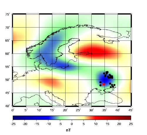
Location of Iron Quartzites (black circles) in the area of Kursk Magnetic Anomaly, red star shows the location of Big Krivoy Rog Deep BoreHole. KMA is shown in acordance with CMP3 model (Br component)(Sabaka et
al., 2000)
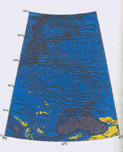
Total Intensity Magnetic Anomaly Map of KMA area at 660 km altitude
from Oersted data. Contour interval is 0.5 nT(Taylor et al., 2000)
Recent study (Taylor et al., 2000) examined
the Oersted magnetic field data over KMA. Magsat and Oersted anomaly data
are in agreement over the region of KMA. The largest anomalies of both
datasets were totally correspondent. Differences in
two anomaly maps were the result of the greater number of tracks
from the Oersted mission. Comparison of these anomalies
with known crustal tectonic features was noted.

 Back to Terrestrial Magnetism Home Page