Earth's Magnetic Field Missions
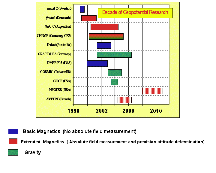
Goals for the 'Decade'
Name: Ørsted
Sponsoring Organizations: Danish research institutions and private
companies. International participation including NASA, CNES, and ESA.
Altitude: 620 to 850 km, elliptic
Magnetic instrumentation: 8 m boom w. triaxial compact spherical
coil fluxgate and scalar Overhauser magnetometer (0.1 nT)
Orientation: non-magnetic star camera (10-60 arc seconds)
Other instrumentation: GPS receiver, particles
Inclination: 96.62 degrees, approximately polar
Local times: 2:30 AM/PM drifting at -23 minutes/month
Launch date: Feb 23, 1999 at 10:29:57 UTC
Launch location: Vandenberg Air Force Base, California, USA
Launch vehicle: Secondary payload; 2nd stage of NASA Delta II
Science and data availability contact: Torsten
Neubert
Lifetime: 14+ mos.
Additional
Information
A special session on 'Earth and Planetary Magnetic Field Satellites' will
be held at the AGU Spring Meeting (May 29-June 2, 2001; Boston, MA). For
further information contact AGU or
Naphsica
Grammatica
News: A successful launch occurred after 11 attempts, a Delta II
record. Boom successfully deployed on March 14, 1999. Overhauser and triaxial
fluxgate instruments are working well and have collected data since boom
deployment. The GPS system has also worked well and is also continuing
to collect data. The star camera has produced usable data about 17-50%
of the time, with illumination and temperature being controlling variables.
An IGRF 2000 candidate based on vector and scalar magnetometer data has
now been accepted.
Name: CHAMP
Sponsoring Organizations: DARA, DLR and GFZ-Potsdam,Germany. International
participation includes NASA, CNES, and DSRI.
Altitude: Less than 300 to 460 km, circular (460 km at start of mission),
eccentricity about 0.001.
Magnetic instrumentation: 4 m boom w. triaxial fluxgate, Overhauser
scalar (0.1 nT)
Orientation: dual non-magnetic star cameras (arc second level)
Other instrumentation: gravity, Digital
Ion Drift Meter , GPS
Inclination: 87.3 degrees
Local times: Initially noon, with a nodal drift rate of 1.5 to 2
deg/day
Launch date: July 15, 2000, 12h UTC
Launch vehicle: Russian Cosmos rocket of PO Polyot (OHB)
Science contacts: Hermann
Lühr (magnetics) and Ch.
Reigber (mission, gravity)
Lifetime: 5 years
Notes: Contact Richard Holme
for
information on data availability. AO expected about March 2001. CHAMP User
Meeting expected at end of April, 2001.
Additional
Information
Name: SAC-C
Sponsoring Organizations: Argentina. International participation
includes NASA (launch, magnetometer) and Denmark (Magnetic mapping package).
Altitude: 702 km circular, sun synchronous
Orbit: Repeating with a 5 day period, active control of orbit.
Magnetic instrumentation: 8 m boom w. triaxial fluxgate, helium scalar
Spacecraft fields: 1 nT at scalar, 2 nT at vector
Orientation: non-magnetic star camera (arc second level)
Other instrumentation: GOLPE GPS experiment (occultation and surface
reflection), 5 band imager (terrestrial and coastal zone imaging)
Inclination: 98.22 degrees
Local times: 10:24 AM (PST) descending node
Launch date: Nov. 18, 2000
Launch vehicle: Delta II (with EO-1)
Science contact: Nils Olsen ,
John
LaBrecque, or Ed Smith
Lifetime: 4 years
Notes: Boom successfully deployed on Jan. 23, 2001. Both magnetometers
appear to be healthy and the calibration process is continuing.
Additional Information (Spanish)
Additional
Information (English)
Name: Sunsat
Sponsoring Organization: University of Stellenbosch, South Africa
Altitude: 600+ to 850 km, elliptic
Magnetic instrumentation: 4 m boom w. triaxial fluxgate (1 Hz)
Orientation: GPS, star imager (>50 arc seconds) & magnetometer
Other instrumentation: High resolution camera for Landsat style imaging
Inclination: 96 degrees, polar
Local times: all
Launch date: Feb 23, 1999 at 10:29:57 UTC
Last contact: Jan. 19, 2001 at 15:22:37 UTC
Launch vehicle: Secondary payload; 2nd state Delta 2
Science contact: Pieter Kotze
Lifetime: 5 yrs
Notes: A student project which flew on the same launch vehicle as
Ørsted.
Additional Information
News: A successful launch occurred after 11 attempts, a Delta II record.
The boom was extended and the magnetometer produced data over Southern
Africa. Stay tuned for Sunsat-2.
Name: ASTRID-2
Sponsoring Organization: Swedish Space Corporation
Altitude: 1000 km, circular
Magnetic instrumentation: 0.5 m boom w. triaxial fluxgate
Orientation: Non-magnetic star camera on a spin-stabilized craft
Orbit determination: NORAD
Other instrumentation: Particles, electric fields, magnetic torquer
Inclination: high, 83 degrees
Local times: ?
Launch date: Dec. 10, 1998
Contact lost: July 24, 1999
Launch vehicle and place: Russian Kosmos 3M; Plesetsk, Russia
Science contact: Lars Bylander
Other contacts: Therese Moreto, DMI; Fritz Primdahl, DTU
Additional Information
News: Boom successfully deployed, spin rate (9 rpm) too fast for use of
star camera. Magnetic field data is currently being evaluated by Fritz
Primdahl and Jose Merayo of DTU.
A preliminary version of their report
is
available.
Name: FEDSAT
Sponsoring Organization: CSIRO, Australia
Altitude: 800 km circular
Magnetic instrumentation: 2.5 m boom w. triaxial fluxgate
Orientation: 20 arc seconds using star camera, GPS for position
Other instrumentation: particles, communications, space physics,
remote sensing, engineering
Inclination: 98.6 degrees
Local times: sun-synchronous
Launch date: November, 2001, the centennial of the Australian Federation
Launch vehicle: Piggyback launch onboard a Japanese rocket.
Science contact: Charles
Barton
Other contact: Brian Embleton
Lifetime: ?
Additional Information
Name: DMSP Block 5
Sponsoring Organization: U.S. Military
Altitude: 840 km
Magnetic Instrumentation: triaxial fluxgate magnetometer (low thermal
drift), body-mounted (F12-F14) or on a 5 m Astromast boom (F15+)
Orientation: Uncertain. Probably between 0.1 to 0.5 degrees because
of incomplete knowledge of orientation of boom relative to spacecraft body
and possible boom flexure. Imaging instrument on spacecraft body has 0.01
degree pointing requirement
Other instrumentation: Imaging
Inclination: high, near polar
Positioning: 400 m RMS spherical error (post-processed by NOAA at
Boulder, Colorado)
Local times: 10 AM/10 PM or Dawn/Dusk
Launch date: F15 was launched on Dec. 12, 1999. F16 will be launched
in August of 2000. F17 and F19 will follow at 3 year intervals as needed.
F15 has been built and ready since 1995.
Launch vehicle: Titan II
Science contact: Frederick J. Rich
,
John Quinn
Lifetime: 3 to 5 years
News: The calibration of F15 is being done by Frederick
J. Rich . John Quinn will
subsequently merge the ephemeris and magnetic field data sets and perform
an evaluation of the data. The data will then become publicly available.
Additional Information
Name: NPOESS
Sponsoring Organization: U.S. Military and civilian
Altitude: 833 km
Magnetic Instrumentation: Boom w. absolute scalar & triaxial
fluxgate
Orientation: 1 arc minute or better
Other instrumentation: weather imaging, space weather, Digital
Ion Drift Meter
Inclination: high, near polar
Local times: 10 AM/10 PM or Dawn/Dusk
Launch date: 2008 (launch as needed, 2 up at all times to 2020)
Science contact: John Quinn
Lifetime: 5 years
Additional Information
Name: SACI-1
Sponsoring Organizations: INPE (Federal Government of Brazil), Brazilian
Academy of Sciences, Agencia Espacial Brasileira (AEB)
Altitude: 750 km, circular
Launch vehicle: Piggyback on a large satellite (China Brazil Earth
Resources Satellite). Launched on a Chinese rocket.
Magnetic Instrumentation: 0.5 m boom with triaxial ring core fluxgate
(magnetometer built at UCLA, digital electronics at INPE)
Orientation: 1 degree, spin-stabilized, 6-10 rpm
Other instrumentation: cosmic rays, plasma bubbles, airglow photometer
Inclination: 98.5 degrees
Local times: 10 AM/10 PM, sun-synchronous
Launch date: Oct. 14, 1999
Science contact: Nalin
Babulal Trivedi
Project Manager: Angelo Neri
Lifetime: 18 months
Reference: Geomagnetic field measurements on a polar microsatellite
SACI-1, N.B. Trivedi et al., in review for Advances in Space Research
News: The satellite was successfully launched but did not respond
to any ground commands nor did it send any data.
Name: Geospace Electrodynamic Connections (GEC)
Sponsoring Organization: NASA
Altitude: strongly elliptical (200 to 2000 km, with dips to as low
as 130 km in the auroral region)
Configuration: 4 satellites organized initially as 'pearls on a string'.
Three-axis stabilized, bullet-shaped, 256 kg of hydrazine, four thrusters,
3000 m/s of Delta V
Magnetic instrumentation: A search-coil magnetometer and a triaxial
fluxgate on a boom hanging from the aft payload module.
Orientation accuracy: unknown, probably some minutes of arc
Other instrumentation: electric field, plasma, particles
Inclination: 83 degrees, near polar
Local times: all, initially 1:36 AM ascending node
Launch date: 2007
Lifetime: 2 years
Additional Information (currently
in science definition phase)
Science/mission contact: Joseph
M. Grebowsky or Jan Sojka
Name: AMPERE
Sponsoring Organization: CNES
Altitude: Near-earth
Magnetic instrumentation: boom with triaxial CSC fluxgate and total
field Overhauser
Orientation accuracy: Low-magnetic star camera (arc second level)
Other instrumentation: GPS
Inclination: low
Launch vehicle: secondary payload on an Arianne
Launch date: 2005
Lifetime: 2 years
Contacts: Coordinator: Pascal
Tarits Science: Gauthier Hulot
Instrumentation:
Michel
Menvielle
Name: Demeter
Sponsoring Organization: CNES,LPCE,IPGP,CETP,CESR
Altitude: 800 km
Magnetic instrumentation: 3 axis search-coil magnetometerr
Other instrumentation: 4 electrical sensors, Langmuir probe, plasma
analyzer, particle detector
Inclination: near polar orbit
Local times: ?
Launch vehicle: Ariane 5 or PSLV
Launch date: 2002
Lifetime: 2 years
Objectives: Study of ionospheric disturbances associated with natural
geophysical phenomena such as earthquakes, volcanic eruptions, or tsunamis.
A secondary objective is to study the electromagnetic disturbances of the
planet linked with human activity.
Contacts: Michel Parrot,
LPCE, Orleans, France
Name: swarm: a Danish Small-Satellite Mission to
Observe the Dynamics of the Earth's Magnetic Field
Sponsoring Organization: ESA, Denmark
Altitude: Circular, preferably below 500 km
Configuration: Multiple satellites in near-polar orbits and a single
satellite in a near-equatorial orbit. The satellites in near-polar oribts
have slightly different inclinations.
Magnetic instrumentation: Each satellite has a CSC vector magnetometer
and an Overhauser magnetometer. A flexible cable boom reduces magnetic
field noise.
Orientation: Non-magnetic star cameras (triple camera heads) and
GPS receivers, resulting in an overall resolution in the 0.1 nT/1 arcsec
range.
Inclination: high, near polar and low, near equatorial
Local times: Different satellites have different drift rates, resulting
in a differential local time evolution
Launch date: 2003 (Solar Minimum)
Science contacts: Fritz Primdahl
,
Nils
Olsen and Eigil Friis-Christensen
Lifetime: 3 years

 Back to Terrestrial Magnetism Home Page
Responsible NASA official:Dr. Herbert Frey
Web Curator: Katia Nazarova (Raytheon)
Email katianh@geomag.gsfc.nasa.gov with comments or suggestions
Last modified on May 15, 2001