| Magnetic Field missions | |||
|---|---|---|---|
| Missions Completed | Flying | Funded, Approved or under Construction | Proposed |
| SACI-1 | Řrsted | SWARM | AMPERE |
| Astrid-2 | DMSP | C/NOFS | GEC |
| Sunsat | CHAMP | ST-5 | - |
| FEDSAT | SAC-C | - | - |
| - | Demeter | - | - |
| Missions Completed | Flying | Funded, Approved or under Construction | Proposed |
|---|---|---|---|
| Lunar Prospector (Moon) | Mars Global Surveyor | - | MEMOIRE (Mars) |
| NEAR Shoemaker (Asteroid) | Mercury Messenger | BEPI-Colombo (Mercury) | ARES (Mars) |
Sponsoring Organizations: Danish research institutions and private companies. International participation including NASA, CNES, and ESA.
Altitude: 620 to 850 km, elliptic
Magnetic instrumentation: 8 m boom w. triaxial compact spherical coil fluxgate and scalar Overhauser magnetometer (0.1 nT)
Orientation: non-magnetic star camera (10-60 arc seconds)
Other instrumentation: GPS receiver, particles
Inclination: 96.62 degrees, approximately polar
Local times: 2:30 AM/PM drifting at -23 minutes/month
Launch date: Feb 23, 1999 at 10:29:57 UTC
Launch location: Vandenberg Air Force Base, California, USA
Launch vehicle: Secondary payload; 2nd stage of NASA Delta II
Science and data availability contact: Peter Stauning
Lifetime: 14+ mos.
News: A successful launch occurred after 11 attempts, a Delta II record. Boom successfully deployed on March 14, 1999. Overhauser and triaxial fluxgate instruments are working well and have collected data since boom deployment. The GPS system has also worked well and is also continuing to collect data. The star camera has produced usable data about 17-50% of the time, with illumination and temperature being controlling variables. The 4th Oersted International Science Team Conference Proceedings were published in June, 2003. The online version of the book is indexed as ISSN 1399-1949 and will probably be available here . For further information on data availability contact Peter Stauning. Orsted continues to collect data well into its sixth year (22 Dec 2005).
Sponsoring Organizations: DLR and GFZ-Potsdam,Germany. International participation includes NASA, CNES, and DSRI.
Altitude: Less than 300 to 460 km, circular (460 km at start of mission), eccentricity about 0.001.
Magnetic instrumentation: 4 m boom w. triaxial fluxgate, Overhauser scalar (0.1 nT)
Orientation: dual non-magnetic star cameras (arc second level)
Other instrumentation: gravity, Digital Ion Drift Meter , GPS
Inclination: 87.3 degrees
Local times: Initially noon, with a nodal drift rate of 1.5 to 2 deg/day
Launch date: July 15, 2000, 12h UTC
Launch vehicle: Russian Cosmos rocket of PO Polyot (OHB)
Science contacts: Hermann Lühr (magnetics) and Ch. Reigber (gravity)
Lifetime: 8 years
Notes: Contact Hermann Luehr for information on data availability.
A CHAMP Science meeting was held in July, 2004 in Potsdam, Germany, and honored the careers of Christoph Reigber and Volker Haak. The 2nd CHAMP Science Meeting was held at the GeoForschungsZentrum in Potsdam, Germany, 1-4 September 2003. The book "Earth Observation with CHAMP: Results from Three Years in Orbit" (Reigber, Luhr, Schwintzer and Wicker, eds.) was published by Springer-Verlag in 2005. For further information contact Hermann Luehr
Sponsoring Organizations: Argentina. International participation includes NASA (launch, magnetometer) and Denmark (Magnetic mapping package).
Altitude: 702 km circular, sun synchronous
Orbit: Repeating with a 5 day period, active control of orbit.
Magnetic instrumentation: 8 m boom w. triaxial fluxgate, helium scalar
Spacecraft fields: 1 nT at scalar, 2 nT at vector
Orientation: non-magnetic star camera (arc second level)
Other instrumentation: GOLPE GPS experiment (occultation and surface reflection), 5 band imager (terrestrial and coastal zone imaging)
Inclination: 98.22 degrees
Local times: 10:24 AM (PST) descending node
Launch date: Nov. 18, 2000
Launch vehicle: Delta II (with EO-1)
Science contact: Nils Olsen
Data availability: A pointer to the data
Lifetime: 4 years
Notes: Boom successfully deployed on Jan. 23, 2001. A workshop to discuss the scientific results from SAC-C was held from December 3-5, 2003 in Buenos Aires. A book is planned. For further information contact Ida Nollmann
Additional Information (Spanish)
Additional Information (English)
Sponsoring Organization: University of Stellenbosch, South Africa
Altitude: 600+ to 850 km, elliptic
Magnetic instrumentation: 4 m boom w. triaxial fluxgate (1 Hz)
Orientation: GPS, star imager (>50 arc seconds) & magnetometer
Other instrumentation: High resolution camera for Landsat style imaging
Inclination: 96 degrees, polar
Local times: all
Launch date: Feb 23, 1999 at 10:29:57 UTC
Last contact: Jan. 19, 2001 at 15:22:37 UTC
Launch vehicle: Secondary payload; 2nd state Delta 2
Science contact: Pieter Kotze
Lifetime: 5 yrs
Notes: A student project which flew on the same launch vehicle as Řrsted.
News: A successful launch occurred after 11 attempts, a Delta II record. The boom was extended and the magnetometer produced data over Southern Africa. Stay tuned for Sunsat-2.
Sponsoring Organization: Swedish Space Corporation
Altitude: 1000 km, circular
Magnetic instrumentation: 0.5 m boom w. triaxial fluxgate
Orientation: Non-magnetic star camera on a spin-stabilized craft
Orbit determination: NORAD
Other instrumentation: Particles, electric fields, magnetic torquer
Inclination: high, 83 degrees
Local times: ?
Launch date: Dec. 10, 1998
Contact lost: July 24, 1999
Launch vehicle and place: Russian Kosmos 3M; Plesetsk, Russia
Science contact: Lars Bylander
Other contacts: Therese Moreto, DMI; Fritz Primdahl, DTU
News: Boom successfully deployed, spin rate (9 rpm) too fast for use of star camera. Magnetic field data is currently being evaluated by Fritz Primdahl and Jose Merayo of DTU. A preliminary version of their report is available.
Sponsoring Organization: CSIRO, Australia
Altitude: 800 km circular
Magnetic instrumentation: 2.5 m boom w. triaxial fluxgate
Orientation: 20 arc seconds using star camera, GPS for position
Other instrumentation: particles, communications, space physics, remote sensing, engineering
Inclination: 98.6 degrees
Local times: sun-synchronous
Launch date: Successfully launched on December 14, 2002, to honor the centennial of the Australian Federation
Launch vehicle: Piggyback launch onboard a Japanese (NASDA) rocket, the HII-A, from Tanegushima.
Science contacts: Brian Fraser, Charles Barton
Other contact: Brian Embleton
Lifetime: Australia's Cooperative Research Centre for Satellite Systems will close at the end of 2005, and with it FedSat(?).
News: Boom with magnetometer successfully deployed: Mid January, 2003. Some results were presented at the Spring, 2004 AGU in Montreal by B. Fraser.
Sponsoring Organization: NASA (A part of the New Millennium Program)
Altitude: Initial perigee at 300 km over the equator, apogee at 4000 km. Perigee will migrate poleward during the mission. The three spacecraft will follow one another like 'pearls on a string' at initial distances of 25 km, increasing during the mission.
Magnetic instrumentation: A boom mounted magnetometer on each of the three spacecraft making up the mini-constellation. The boom is 1 m long, comparable to the size of the nanospacecraft, each of which weighs about 20 kg.
Orientation: A spinner. No star camera, no GPS. Sun sensor on spacecraft body should provide orientation accuracy of about 0.1-0.3 degree
Inclination: 105 degrees
Local time: Dawn-Dusk
Launch date: Feb 28, 2006
Length of mission: 90+ days
Launch vehicle: Pegasus
Science contact: Jim Slavin
Sponsoring Organization: U.S. Military
Altitude: 840 km
Magnetic Instrumentation: triaxial fluxgate magnetometer (low thermal drift), body-mounted (F12-F14) or on a 5 m Astromast boom (F15+)
Orientation: Uncertain. Probably between 0.1 to 0.5 degrees because of incomplete knowledge of orientation of boom relative to spacecraft body and possible boom flexure. Imaging instrument on spacecraft body has 0.01 degree pointing requirement
Other instrumentation: Imaging
Inclination: high, near polar
Positioning: 400 m RMS spherical error (post-processed by NOAA at Boulder, Colorado)
Local times: 10 AM/10 PM or Dawn/Dusk
Launch date: F15 was launched on Dec. 12, 1999 and is currently operational. F16 was launched on Oct. 18, 2003 and declared operational on Nov. 19, 2003. F17 and F19 will follow at 3 year intervals, or as needed.
Launch vehicle: Titan II
Science contact: Frederick J. Rich , Susan McLean
Lifetime: 3 to 5 years
News: The calibration of F15 is being done by Frederick J. Rich . John Quinn was to subsequently merge the ephemeris and magnetic field data sets and perform an evaluation of the data. John Quinn has now retired. NOAA/NGDC may take over the preparation of the data.
Sponsoring Organizations: INPE (Federal Government of Brazil), Brazilian Academy of Sciences, Agencia Espacial Brasileira (AEB)
Altitude: 750 km, circular
Launch vehicle: Piggyback on a large satellite (China Brazil Earth Resources Satellite). Launched on a Chinese rocket.
Magnetic Instrumentation: 0.5 m boom with triaxial ring core fluxgate (magnetometer built at UCLA, digital electronics at INPE)
Orientation: 1 degree, spin-stabilized, 6-10 rpm
Other instrumentation: cosmic rays, plasma bubbles, airglow photometer
Inclination: 98.5 degrees
Local times: 10 AM/10 PM, sun-synchronous
Launch date: Oct. 14, 1999
Science contact: Nalin Babulal Trivedi
Project Manager: Angelo Neri
Lifetime: 18 months
Reference: Geomagnetic field measurements on a polar microsatellite SACI-1, N.B. Trivedi et al., in review for Advances in Space Research
News: The satellite was successfully launched but did not respond to any ground commands nor did it send any data.
Sponsoring Organization: NASA
Altitude: strongly elliptical (200 to 2000 km, with dips to as low as 130 km in the auroral region)
Configuration: 4 satellites organized initially as 'pearls on a string'. Three-axis stabilized, bullet-shaped, 256 kg of hydrazine, four thrusters, 3000 m/s of Delta V
Magnetic instrumentation: A search-coil magnetometer and a triaxial fluxgate on a boom hanging from the aft payload module.
Orientation accuracy: unknown, probably some minutes of arc
Other instrumentation: electric field, plasma, particles
Inclination: 83 degrees, near polar
Local times: all, initially 1:36 AM ascending node
Launch date: No fixed date (2013?)
Lifetime: 2 years
Science/mission contact: Joseph M. Grebowsky or Jan Sojka
Sponsoring Organization: CNES (Phase A ongoing through November, 2001)
Altitude: Near-earth, possibly with an aerobraking phase
Magnetic instrumentation: boom with triaxial CSC fluxgate and total field Overhauser
Orientation accuracy: Low-magnetic star camera (arc second level)
Other instrumentation: GPS
Inclination: undecided
Launch vehicle: secondary payload on an Arianne
Launch date: No fixed date
Lifetime: 2 years
Contacts: Coordinator: Pascal Tarits Science: Gauthier Hulot Instrumentation: Michel Menvielle
Sponsoring Organization: CNES,LPCE,IPGP,CETP,CESR
Altitude: 800 km
Magnetic instrumentation: 3 axis search-coil magnetometerr
Other instrumentation: 4 electrical sensors, Langmuir probe, plasma analyzer, particle detector
Inclination: near polar orbit
Local times: ?
Launch vehicle: Ariane 5 or PSLV
Launch date: June 29 2004
Lifetime: 2 years
Objectives: Study of ionospheric disturbances associated with natural geophysical phenomena such as earthquakes, volcanic eruptions, or tsunamis. A secondary objective is to study the electromagnetic disturbances of the planet linked with human activity.
Contacts: Michel Parrot, LPCE, Orleans, France
News: The scientific mission began on 11 August 2004.
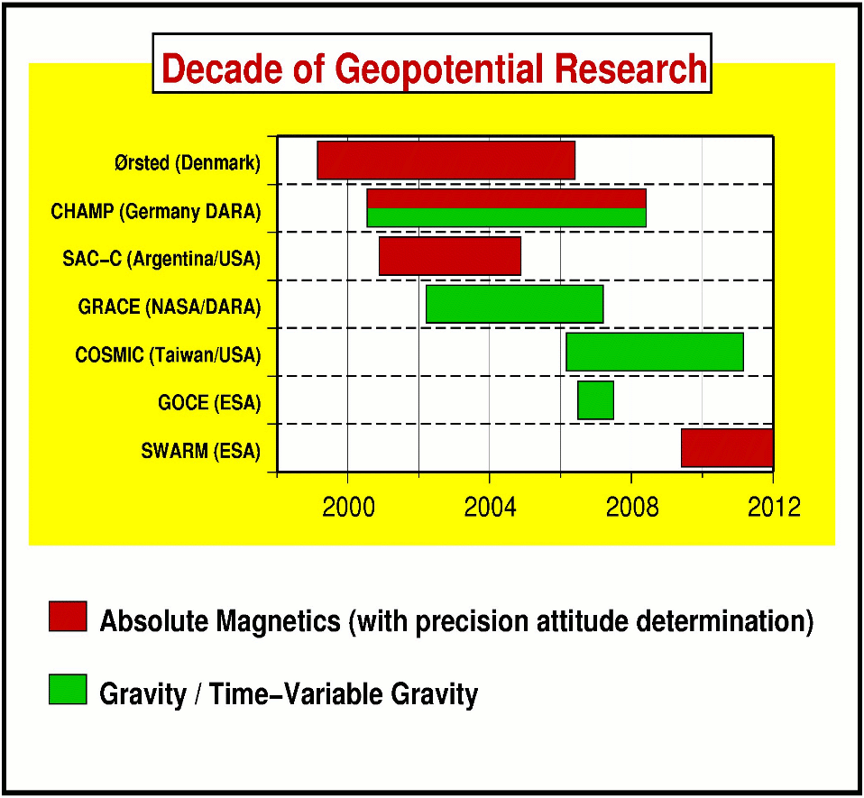
Sponsoring Organization: ESA, Denmark, France, Germany, NASA/CSA involvement
Altitude: Two spacecraft at 450 km separated by 150 km in an E-W direction, one at 550 km.
Configuration: Multiple satellites in near-polar orbits.
Magnetic instrumentation: Each satellite will have a CSC vector magnetometer and an absolute magnetometer. A GPS receiver, an electric field instrument, and an accelerometer will also be included.
Orientation: Non-magnetic star cameras (triple camera heads) and GPS receivers, resulting in an overall resolution in the 0.1 nT/1 arcsec range.
Inclination: high, near polar.
Local times: Different satellites have different drift rates, resulting in a differential local time evolution
Launch date: 2009
Science contacts: Eigil Friis-Christensen , Hermann Luehr and Gauthier Hulot
Lifetime: 4 years
Notes: Swarm has now been selected for full implementation by ESA. Phase B began in 2005. The First Swarm International Science Workshop will be held in Nantes, France from 3-5 May 2006.
Sponsoring organizations: USA including Dept.of Defense, Air Force Research Laboratory, NASA, Naval Research Laboratory, and GSFC.
Altitude: 400-710 km
Magnetic instrumentation: 3-axis fluxgate designed and built by Mario Acuna. Sensitivity range +- 45000 nT. DC measurements reported at 1 Hz. AC measurements reported at 16 Hz. Magnetometer and electric field data are sampled simultaneously. 50 nT noise level predicted for magnetometer based on spacecraft fields and boom length.
Boom: 0.6 m
Orientation: Via star sensor. Attitude accuracy estimated to be at least 0.1 degree.
Inclination: 13 degrees
Local times: All
Launch date: Early 2006
Science contacts: Robert Pfaff
Lifetime: 1 year
Notes: The magnetometer is part of the electric field package. In addition to the vector electric field instrument, the spacecraft is also carrying a planar Langmuir probe, a neutral wind monitor, and ion velocity monitor, a GPS receiver for remote ionospheric sensing, and a radio beacon.
Sponsoring Organization: NASA
Altitude: Elliptical with 85 km periapsis followed by 380 km circular
Magnetic instrumentation: a triaxial fluxgate in both solar panels
Orientation: Attitude to within 1 degree
Other instrumentation: Imaging, electron reflectometer
Inclination: 89 degrees
Sampling Rate: Up to 24 Hz
Local time: 2 PM/2 AM
Science contacts: Mario Acuna 301-286-7258 (GSFC), Bob Lin (Berkeley) or Dave Curtis (Berkeley)
News: Began orbiting Mars in Sept, 1997. MGS is now in a circular mapping orbit. The instrument was healthy and collecting data in December of 2005.
Sponsoring Organization: NASA
Altitude: 100 km for 1st year, then 20 km
Magnetic instrumentation: 4.5 m boom with triaxial fluxgate
Orientation: Spacecraft is spinning at 12 rpm, Attitude to within 1 degree
Other instrumentation: spectrometers, gravity, electron reflectometer
Inclination: near-polar
Launch time: Jan. 9, 1998
Lifetime: Crashed onto moon on July 31, 1999
Launch vehicle: Lockheed Launch Vehicle 2
Science contacts: Mario Acuna 301-286-7258 or Lon Hood 520-621-6936
Sponsoring Organization: NASA
Altitude: 200 km until April, then 100 km, finally landing in Feb, 2001.
Magnetic instrumentation: Triaxial fluxgate mounted on high-gain antenna feed, 1 m from spacecraft bus.
Other instrumentation: spectrometers, laser rangefinder, imager
Launch time: Feb. 17, 1996
Launch vehicle: Delta-2 Insertion into orbit: Feb. 14, 2000
Lifetime: 1 year
Science contacts: Mario Acuna 301-286-7258, Chris Russell, or Brian Anderson
Sponsoring Organization: NASA
Magnetic instrumentation: 3.6 m boom with triaxial fluxgate
Other instrumentation: imagers, laser altimeter
Launch time: August 3, 2004
Flybys: July, 2007 and April, 2008 at 200 km altitude
Mapping: April, 2009, with input from earlier flybys.
Lifetime: >1 year
Data availability: Data will be publicly available subsequent to calibration.
Science contacts: Mario Acuna 301-286-7258, Jim Slavin 301-286-5839 or Sean Solomon 202-478-8850
News: The magnetometer was turned on and successfully tested in the stowed position. Boom deployment will occur next year.
Sponsoring Organization: ESA, Japan
Magnetic instrumentation: Magnetometer on Magnetospheric Orbiter
Other instrumentation: ion spectrometer, ion/electron analyzer, wave analyszer, cold plasma detector, energetic particle detector
Orientation: spin-stabilized, 15 RPM
Inclination: polar Orbit: 400 x 12000 km
Launch time: Sept, 2012
Lifetime: 1 year
Proposing Organizations: CNES
Altitude: Circular at 400 km, followed by elliptical (170 x 1000 km).
Magnetic instrumentation: CSC fluxgate magnetometer
Inclination: near-polar
Launch date: None scheduled
Science contacts: Mioara Mandea or Eric Chassefiere
Concept: A jet-powered airplane
Proposing Organizations: NASA Mars Scout finalist
Magnetic instrumentation: Wing-tip mounted triaxial fluxgates
Altitude: 1.5 km above the surface
Observation location: A 680 km traverse of the southern highlands near the large magnetic features in Terra Sirenum/Cimmeria
Other Instrumentation: Mass Spectrometry, water vapor, camera
Launch date: None scheduled
Science contact: Jack Connerney (+1 301 286 5884)