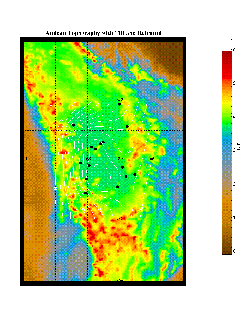
The topography of the Central Andes is represented in color. The sites at which shoreline height measurements were made are indicated by black dots. The inferred pattern of net vertical motion (rebound plus tilting) is indicated by white contours.
Figure available as PostScript (544k) or GIF (175k)
Paleolimnology is the study of ancient lakes. A burgeoning sub-discipline of this field might be entitled limneotectonics, or the study of deformations of the solid earth as recorded in the shorelines and sediments of lakes. The shorelines of paleolakes provide the unusual combination of unambiguous records of both climatic change and tectonic motions. Changes in the surface area of a closed-basin lake provide direct evidence of climatic change. Departures from horizontality of the shorelines of a lake provide evidence of vertical crustal motions. Together, these disparate types of evidence can be used to establish constraints on the rates and processes responsible for changes above and below the surface of the Earth.
Lakes which occupy hydrologically closed drainage basins respond very sensitively to climatic change. An increase in precipitation or a decrease in evaporation will cause the surface area of the lake to increase until hydrologic balance is re-established. The Altiplano of Bolivia is presently a cold high desert, but at elevations below 3800 m the landscape is dominated by coast geomorphic features. During colder and/or wetter episodes in the past, the hydrologically closed basins of the Altiplano have contained substantial lakes. The largest of these was Lake Minchin, which extended 200 km E-W and 400 km N-S, and attained a depth of 140 m. It was thus roughly comparable in size to the present Lake Michigan.
The sediments and shoreline deposits of Lake Minchin preserve a valuable, but largely untapped record of tropical climatic change. The present climate of the Altiplano represents a region of extremely high precipitation gradients. The western flank of the basin is part of the hyper-arid Peruvian coast desert, with precipitation rates < 100 mm/year. The eastern flank of the basin abuts the Amazon rainforest, with precipitation rates > 1500 mm/year. The potential evaporation rates are less variable, averaging 1400 mm/year. It is clear that even minor lateral shifts in the precipitation zones would produce major shifts in the hydrologic balance. To attain the highest level of Lake Minchin would require an increase in the basin-average precipitation of roughly 300 mm/year. Recent work on this problem by a group lead by Bruce Bills (921) has established that the highest shoreline was formed roughly 17,000 years ago.
As the lake fluctuates in depth, it forms erosional and depostional shorelines which record the positions of the lake surface at various epochs. Each of these shorelines are formed on a horizontal (geoidal) surface. Present departures from horizontality are thus a measure of accumulated net vertical motion since the shoreline formed. For sufficiently large lakes, the crustal load of the water itself is adequate to produce tens of meters of vertical deflection of the crust. The actual amount and spatial pattern of deflection depends on the geometry of the imposed load (which is well known) and on the long-term strength of the sub-strate (which is almost completely unknown). Thus, examination of the spatio-temporal pattern of shoreline deformation provides an opportunity to determine the viscosity of the crust and upper mantle. This approach has been applied for over a century in a few selected locations, but has never before been attempted in the Central Andes.
In a recent application of space geodetic techniques to this problem, a group led by Bruce Bills (921) has measured the amount and spatial pattern of net vertical crustal deformation which has accumulated in the Central Andes during the 17,000 years since formation of the shorelines of paleolake Minchin. The measurement technique relied an a relatively new application of the Global Positioning System, which allows real-time positioning with ~1 m accuracy. The space component of the Global Positioning System (GPS) comprises a constellation of 24 satellites in 6 different orbital planes. Each satellite broadcasts information from which an appropriate ground-based radio receiver can determine its range to the satellite. With a minimum of four satellites in view, a GPS receiver can determine the 3 components of its spatial position, and a clock correction term. Typical real-time positional accuracy is of order 100 m, which is not good enough for our shoreline study. However, many of the error sources are shared between nearby receivers (separations up to several hundred km), and real-time differential positions better than 1 m can be obtained at 1 Hz sampling rates. The strategey used for the Bolivian shoreline measurements included 3 receivers. One was left at a fixed location for the entire campaign. This served as a "fiducial" location for all of the shoreline traverses. The other two receivers were transported by vehicle to the shoreline sites. At each site, one receiver (the "base" station) would stay fixed, with its antenna mounted on a standard surveying tripod. The other receiver (the "rover") was placed in a back-pack and carried along as the team hiked over the sequence of shorelines. Real-time differential positions of the shoreline features were noted, with 1 m precision. The position of the "base" receiver, relative to the "fiducial" was determined later by simultaneously analyzing data from both receivers. The final analysis, which was intended to locate our local array within a global geodetic framework, also included GPS data from true fiducial sites in Santiago (Chile), Bogota (Columbia), and Fortaleza (Brazil).
We determined that the weight of the lake was sufficient to depress the crust of the Earth by (27 + 1) m. Radiocarbon dates on gastropod (snail) shells found at the highest shoreline establish that the lake reached its greatest extent roughly 17,000 years ago. This is somewhat later than the maximum of glacial loading in North America. The pattern and timing of the crustal response to the load implies that the effective lithospheric thickness is less than 40 km, and the effective viscosity of the upper mantle is less than 5 10^(20) Pa s. The lithospheric thickness number is somewhat of a surprise, since seismic observations have established that the crustal thickness in the Central Andes is roughly 70 km. Further observations of the rebound pattern on the lower shorelines, and an improved chronology for the loading will eventually provide better resolution of the strength versus depth profile.
Another surprise was that the pattern of shoreline elevations records a regional-scale tilting down to the NW. When the rebound signal is removed, the residual heights are roughly 40 m greater in the exteme SE corner of the lake basin than they are in the NW extremity. The cause of this tilting is still unknown, but it is presumably related to the ongoing subduction of the Nazca tectonic plate beneath the Andes. The rate of horizontal crustal convergence in that subduction zone is last several million years. The observed tilting on the Lake Minchin shorelines corresponds to an average rate of differential vertical motion of 2 mm/year over the last ~20 thousand years.
Reference: B.G. Bills, S.L. de Silva, D.R. Currey, R.S. Emenger, K.D. Lillquist, A. Donnellan, and B. Worden, Hydro-isostatic deflection and tectonic tilting in the central Andes: Initial results of a GPS survey of Lake Minchin shorelines, Geophys. Res. Lett. 21, 293-296, 1994.
Sponsor: Office of Mission to Planet Earth