GEODYNAMICS 2003:
THE YEAR IN REVIEW
Annual Report of the Geodynamics Branch
Laboratory for Terrestrial Physics
Goddard
Space Flight
Center
WELCOME
Thank you for your interest in our annual report. In the pages that follow you will find highlights of our research activities for calendar year 2003. This year we include only those studies which reached a significant level of maturity in each of the five main areas in which we work (Crustal Deformation, Geomagnetism, Topography and Surface Change, Planetary Geology and Geophysics, and Orbital-Rotational-Climatic Interaction). [More extensive background material on our research areas was described in the 2001 Annual Report, which is also available as a link through our web site.] The majority of the articles presented here result from papers actually published in CY 2003. The final section of the Annual Report includes publications submitted, accepted and published in 2002 and presentations given by members of our Branch both at major national and international meetings and elsewhere.
Our group consists of 12 civil servants, and about the same number of full-time contractors and visiting scientists. Last year 20 students, faculty and other visitors spent time working with us. Despite our relatively small size, we are involved in a wide range of Earth Science and Space Science (planetary) research and mission support activities. Our people are contributing to the currently operating Mars Global Surveyor, and the Oersted and CHAMP magnetic satellites, and providing support to the ICESat mission. We are deeply involved in simulation studies for the possible SWARM magnetic field mission. We also provide significant programmatic support for HQ Solid Earth and Natural Hazards and the Mars Data Analysis and Mars Fundamental Research Programs. Our staff, in addition to their highly successful individual research activities, are heavily involved in proposal and paper reviews as well as mission design and readiness reviews in both Earth and Space Sciences.
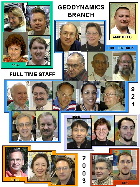
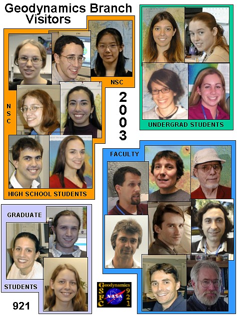
A pictorial overview of our group is shown on the following pages. You can find out more about these individuals by visiting our Branch web site (http://denali.gsfc.nasa.gov or http://geodynamics.gsfc.nasa.gov) and clicking on “Who are We?”. Our branch web page also contains monthly science highlights and links to a variety of other activities.
We hope you enjoy reading this annual description of our activities, and welcome any comments you might have with regard either to the content or the format of this presentation. Please feel free to contact me or any of the individuals in our group at any time.
--Herb Frey
Head, Geodynamics Branch
GEODYNAMICS 2003:
THE YEAR IN REVIEW
TABLE OF CONTENTS
GEODYNAMICS STAFF AND VISITORS
GEODYNAMICS BRANCH RESEARCH - HIGHLIGHTS OF 2003
Lidar
Mapping
Reveals
ICESat Calibration and Validation: Land Products (David Harding)
Glacier
Ice Mass Fluctuations and
Fault Instability in Tectonically Active
The Role of CO2 in Orbital-Scale Climate Changes (Han-Shou Liu)
Atmospheric Rotational Effects on Mars Based on the NASA Ames General Circulation Model: Angular Momentum Approach (Braulio Sanchez)
Polar Wander on Triton and Pluto (David Rubincam)
A Solar System Survey of Forced Librations in Longitude (Bruce Bills)
Gravitational Core-Mantle Coupling and Length-of-Day (David Rubincam)
Satellites Seek Gravity Signals for Probing the Earth’s Interior (Han-Shou Liu)
Obliquity, Precession, and Geomagnetism (Han-Shou Liu)
Geomagnetic Probing of Core Geodynamics (Coerte Voorhies)
Satellite-Altitude-Magnetic
Data over the Mineralized
Region of
Balloon Geomagnetic Survey at Stratospheric Altitudes (Katherine Nazarova)
Submission of the End-to-End Simulator Package for swarm (Michael Purucker)
Visible and Buried Impact Basins on Mars and the Demise of the Global Magnetic Field (Herbert Frey)
GRIDVIEW: Software for Exploring Mars Topography and More (James Roark)
GEODYNAMICS BRANCH PUBLICATIONS IN 2003
GEODYNAMICS BRANCH PRESENTATIONS IN 2003
Geodynamics Staff
(additional staff information)
(additional
visitor information)
GEODYNAMICS BRANCH RESEARCH
2003 HIGHLIGHTS
INTRODUCTION
Research in the Geodynamics Branch covers a wide range of subjects in the broad disciplines of geophysics, geology, geodesy and geodynamics for both the Earth and solid planetary bodies, especially Mars. Surface and satellite data, models derived from these, and other observational and theoretical information are used to help improve our understanding of the evolution of the Earth’s core, mantle and crust, and the character and evolution of Earth and planetary surfaces. Geodynamics includes studies of the processes which operate or have operated to produce the observed present-day state and motions of the crust and surface.
Current research in the Geodynamics Branch falls into five major areas: Crustal Deformation, Geomagnetism, Topography and Surface Change, Planetary Geology and Geophysics, and Orbital-Rotational-Climatic Interaction. Below are described some of the current activities in each of these areas that reached a mature level this last year. The work presented here often falls into more than one area, as these are often overlapping and related to one another. For example, this year a number of studies relevant to Planetary Geology and Geophysics are Orbital-Rotational-climatic Interaction studies. Background for each of these areas can be found in the 2001 Annual Report and in other links available through this web site. Additional progress and ongoing work for this year is indicated by papers given at national and international meetings as well as by papers submitted and accepted (as well as published) during the year.
TOPOGRAPHY AND SURFACE CHANGE / CRUSTAL DEFORMATION
Lidar Mapping Reveals
David Harding (David.J.Harding@nasa.gov)
More
than 10,000 km2 of high-resolution, public-domain topography
data
acquired by commercial airborne lidar mapping for the Puget Sound Lidar
Consortium (PSLC) is revolutionizing investigations of active faulting,
landslides, continental glaciation, and surficial processes in the
seismically
active Puget Lowland region of
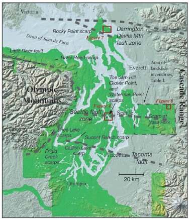
Figure 1. Location of Puget Sound Lidar Consortium mapping (green), and Puget Lowland fault zones (dashed grey).
The Puget Lowland—the population and economic center of the Pacific Northwest—presents special problems for hazards investigations, with its young glacial topography, dense forest cover, and urbanization. Lidar mapping during leaf-off conditions has led to a detailed digital model of the landscape beneath the forest canopy. The surface thus revealed contains a rich and diverse record of previously unknown surface-rupturing faults, Holocene and Pleistocene shoreline terraces documenting land surface elevation changes relative to sea level, deep-seated landslides, and glacial features.
The lidar mapping is accomplished using a small-footprint, multiple discrete return, scanning laser altimeter system operated by TerraPoint, LLC following data specifications established by Harding and Haugerud. A nominal density of one laser pulse per square meter produces a densely sampled lidar point cloud. The discrete returns are classified as being from ground, vegetation, or buildings, based on spatial filtering, from which high-resolution digital elevation models of the first-return surface (essentially a canopy top model) and the “bald Earth” (vegetation and buildings removed) are derived.
More
than half a dozen suspected postglacial fault scarps have been
identified by
the lidar mapping (Figure 1). Five scarps that
have been
examined in detail by trenching show evidence of large, Holocene,
surface-rupturing earthquakes. Carbon dating of organic
material
on fault surfaces exposed by the trenching documents that repeated
earthquakes
have occurred during the last 10,000 years. In addition, the
lidar
mapping enables detailed measurements of shoreline terrace elevations
that
record the amount of surface uplift produced by the earthquakes, and
the
discovery of previously unrecognized landslides, many likely generated
by
earthquake ground shaking (Figure 2). Information on the location, age,
offsets, and magnitudes of these newly documented earthquakes and on
the
resulting distribution of surface deformation and landslides is
redefining our
understanding of the seismic hazard threatening this populous region.
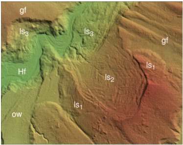
Figure 2. Landslides revealed in shaded relief lidar image of ground topography beneath vegetation, with colors from green to red representing increasing elevation. View is 3.5 km wide and the grid spacing is 6 ft (1.8 m). Geomorphic units are gf—glacially fluted surface; ow—glacial outwash surface; ls—landslide, 1 (oldest) to 3 (youngest); Hf—Holocene fluvial surface.
ICESat Calibration and Validation: Land Products
David Harding (David.J.Harding@nasa.gov)
In addition to its primary objective measuring ice sheet elevation change, the ICESat mission acquires globally distributed elevation profiles of the land surface. These profiles provide high-accuracy measurements of land and mountain glacier topography, tied to a uniform, global reference frame, useful for geodetic control of Digital Elevation Models and for observing topographic change caused, for example, by natural hazards and glacier dynamics. In addition, the backscatter waveforms acquired for each laser pulse characterize the within-footprint height distribution of illuminated surfaces, providing a means to measure geomorphic relief, due to ground slope and roughness, in vegetation-free areas and forest canopy height in areas of low relief.
The geolocation (horizontal and vertical position) and footprint surface parameters in the ICESat Land Products dataset are being validated by David Harding, Jeanne Sauber and Claudia Carabajal of the Laboratory for Terrestrial Physics. Techniques have been developed to assess geolocation accuracy by matching ICESat profiles to moderate resolution (10 to 30 m) Digital Elevation Models (DEMs) (Fig. 1) and by matching observed waveforms (Fig. 2) to simulated waveforms derived from high resolution (1 to 5 m) DEMs acquired by airborne lidar mapping of land and glacier cal/val sites.
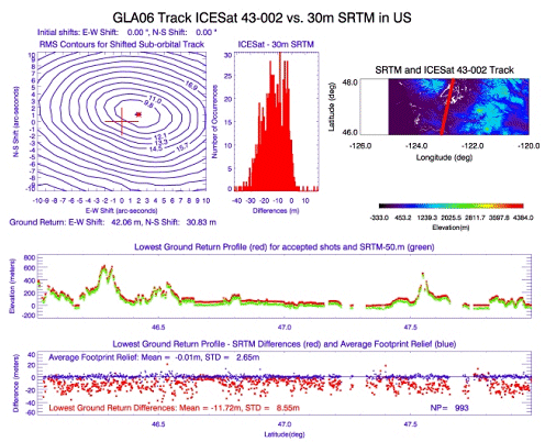
Figure 1. ICESat ground track (red) across color-coded Shuttle Radar Topography Mission DEM (top right), ICESat (red) and DEM (green, vertically offset for clarity) elevation profiles along the track (middle), elevation residual contours from profile shifting (top left) with starting location (plus) and best-fit location (asterisk), and elevation residuals (DEM minus lowest ground from ICESat waveforms) along the profile (red points, bottom) and as a histogram (top center).
Figure 1 shows a profile matching result, where iterative spatial searching defines the best-fit location based on minimization of profile-to-DEM elevation residuals, using a DEM from the Shuttle Radar Topography Mission (SRTM). This approach identified geolocation errors in initial ICESat data releases, and has confirmed improvements in subsequent releases that account for pointing biases. With the spatial match between ICESat and the DEM established, error characteristics of the DEM are quantified, such as the upward bias of the SRTM radar phase center elevations in vegetated areas.
Waveform matching provides a more precise assessment of gelocation accuracy and validates surface roughness and vegetation height parameters by utilizing very detailed DEM representations of ground or glacier topography and
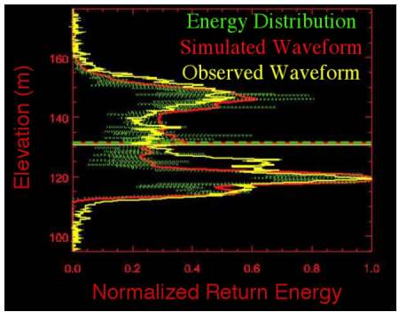
Figure 2. Elevation distribution of normalized energy for an observed ICESat waveform from a forested landscape (yellow) compared to the distribution of illuminated surfaces (green) and the resulting simulated waveform (red) at the ICESat footprint location obtained from a high-resolution DEM
vegetation cover. A grid-based waveform simulation is used to approximate the laser pulse interaction with the Earth’s surface using the high-resolution DEM as input and accounting for the ICESat pulse width and far-field energy pattern, and receiver FOV transmission and impulse response. Optimal matches are determined by minimizing the observed-to-simulated waveform residuals using an iterative spatial search. Observed to simulated waveform comparisons for forested landscapes (e.g. Figure 2) demonstrate that the ICESat waveforms are a very precise and accurate measure of the vertical structure of surfaces illuminated by the laser footprint.
Glacier Ice Mass
Fluctuations
and Fault Instability in Tectonically Active
Jeanne Sauber (Jeanne.Sauber@nasa.gov)
Across
southern
The ice changes associated with Bering Glacier’s most recent surge cycle are large enough to cause discernible surface displacements. Additionally, ice mass fluctuations associated with the surge cycle can modify the short-term seismicity rates in a local region. For the thrust faulting environment of the study region a large decrease in ice load may cause an increase in seismic rate in a region close to failure whereas ice loading may inhibit thrust faulting.
Prior to the 1979 St. Elias earthquake (M=7.2, star in Figure 1), the main thrust zone below the study region had been locked since the 1899 earthquakes and strain had been accumulating. During this same time period ongoing wastage of southern Alaska glaciers was 100’s of meters up to almost a 1 km. We used estimates of ice thickness decrease to calculate the changes in the fault stability margin around the region of the 1979 St. Elias earthquake and aftershocks. Our results suggest that the cumulative decrease in the fault stability margin due to ice wastage between 1899 and 1979 was large and would promote thrust faulting. Since earthquake hazard evaluations are based on the paleoseismic history of the region, for glaciated areas the concurrent glacial history should be considered in this evaluation.
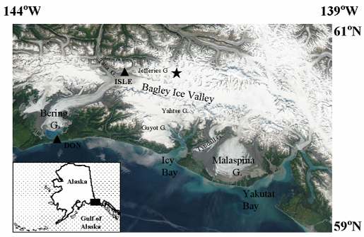
Figure 1. The
ORBITAL-ROTATIONAL-CLIMATIC INTERACTIONS
The Role of CO2 in Orbital-Scale Climate Changes
Han-Shou Liu (Hanshou@core2.gsfc.nas.gov)
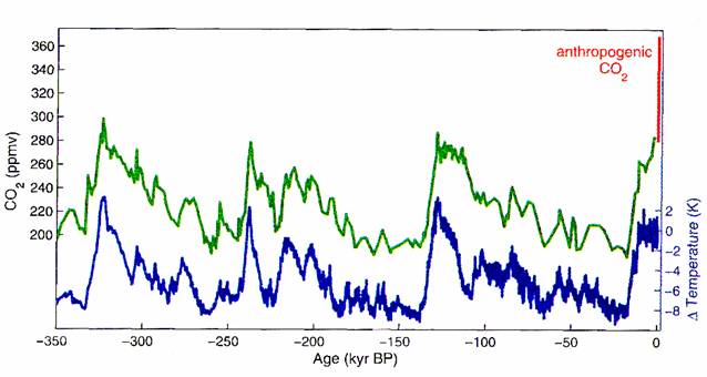
Correlation analysis can be applied to climate-related time series for investigating the causal relationship between CO2 concentration and climate change. A new analysis by Liu, Kolenkiewicz and Wade (2003), has shown that fluctuations in insolation reaching the Earth due to orbital and rotational motion of the Solid Earth can explain major climate changes up to recent time and that the sensitivity of climate to the concentration of CO2 is much less than previously estimated. The new study shows that insolation pulsation in terms of surplus of solar heating due to orbital motion is associated with the climate changes and atmospheric concentrations of CO2.
Ice cores provide access to palaeoclimate data series that include local temperature and precipitation rate, moisture source conditions, wind strength and aerosol fluxes of marine, volcanic, terrestrial, cosmogenic and anthropogenic origin. They are unique with their entrapped air inclusions in providing direct records of past changes in atmospheric trace-gas composition. The ice drilling project has already provided a wealth of such information for the past three glacial-interglacial cycles. In particular, there is a close and strong correlation between temperature variations and atmospheric concentration of CO2. This discovery may argue that CO2 is important as amplifier of the initial
orbital forcing and may have significantly contributed to the abrupt climate changes. But this does not mean that CO2 concentration is the cause of glacial-interglacial climate change. In fact, CO2 concentrations during the past 350 thousand years are the effect and consequence of rapid temperature increases caused by insolation pulsation. Therefore, ice core results should not be used to infer an empirical estimate of the sensitivity of global climate to future anthropogenic increases of CO2 concentration.
In addition, the new study has found that the intensity of the insolation pulsation is dependent on latitude. At high latitude, it provides extreme climate warming conditions for greenhouse-gas concentration. However, the climate warming effect decreases markedly in low latitude regions, predicting cool tropical temperature during supposed greenhouse episodes. It appears that this is what is recently recorded in ice drilling project. Therefore, the new research development of insolation pulsation may provide an important physical mechanism for understanding the cool-tropic paradox in the current climate models of global greenhouse warming. Only the insolation pulse can stimulate an extraordinarily efficient heat–transport mechanism on Earth.
Much of the current debate on climate change is driven by the observation of anthropogenic CO2 concentration. Global greenhouse warming is controversial because the primary role of CO2 in determining global temperature is in question. This study is of relevance with respect to the continuing debate on climate change in the future.
ORBITAL-ROTATIONAL-CLIMATIC INTERACTION / PLANETARY GEOLOGY &
GEOPHYSICS
Atmospheric Rotational Effects on Mars Based on the NASA Ames General Circulation Model: Angular Momentum Approach
Braulio Sanches (Braulio.V.Sanchez@nasa.gov)
The objective of this investigation is to use the angular momentum methodology to compute and analyze how the atmosphere affects the equatorial components of the rotation of Mars, based on outputs from the NASA Ames General Circulation Model (GCM). The model provides values of wind velocity, density and pressure, which serve as inputs to the calculation of the terms which appear in Liouville’s equations.
The rotational variations of a planet can be analyzed into axial and equatorial components. The axial variations (along the z-axis, which is the rotation axis) are reflected in changes in the length of day (LOD). The equatorial variations (x, y) produce changes in the orientation of the axis of rotation (polar motion). The solution of Liouville’s equations provides the changes in planetary rotation, i.e., changes in LOD and polar motion.
The methodology of planetary rotational investigations can follow the angular momentum approach or the torque approach. The chosen methodology determines the boundaries of the appropriate control volume. The angular momentum method involves the computation of terms containing the products of inertia of the atmosphere (“mass terms”) and their time derivatives, as well as relative angular momentum terms (“motion terms”) and their derivatives.
The torque approach was used in a previous investigation by Sanchez et al. (2003) to compute polar motion and LOD variations. The LOD variations were computed also using the angular momentum methodology.
The NASA Ames GCM is a finite difference model based on the primitive equations of meteorology expressed in spherical sigma coordinates (s = pressure at height / surface pressure). The resolution is 7.5º (latitudinal) by 9º (longitudinal). The version of the model used here has 30 vertical layers extending from the surface to 100 km. The output files are written every 1.5 hours of simulated time, 16 times per sol. There are 10704 records in the data file, representing a time span of 669 sols (687 Earth days) which is the length of the Martian year.
The outputs from the NASA Ames GCM provide a 1.5 hour sampling rate, therefore the results for the forcing functions are not limited to annual and semi-annual components.
The condensation and sublimation of CO2 on the surface and in the atmosphere of Mars produce changes in the atmospheric mass distribution as well as changes in the polar caps. From the standpoint or rotational dynamics these changes are manifested in time variations in the moments and products of inertia. Another source of rotational variations is due to the atmospheric winds, which contribute to the relative angular momentum terms.
The amount of atmospheric mass involved in condensation and sublimation is equal to 16.52% of the total atmospheric mass.
It is possible to consider the (x, y) components of the polar displacement as components of a vector characterized by magnitude = (x2 + y2) 1/2. The maximum pole displacement due to ice formation and sublimation is 32.8 cm, occurring at 548 sols. Atmospheric mass variations yield a maximum of 40.9 cm at 478 sols. The combined effect has a maximum of 35.3 cm at 616 sols.
Table 1 lists the main harmonics for the solution combining the ice caps and atmospheric mass variation effects. The amplitudes of the (1/4)-annual and (1/3)–annual harmonics for the combined solution are certainly within the range of detection of future geodetic missions to Mars, such as the planned NetLander Ionospheric and Geodesic Experiment (NEIGE).
Table 1. Main harmonics of polar motion displacement:
Ö x2 + y2 . Ice and atmospheric effects combined.
Cycles per year Period (sols) Amplitude (cm)
4 167.25 3.96
3 223 3.03
1 669 2.52
2 334.5 0.79
5 133.8 0.61
8 83.625 0.58
9 74.333 0.45
6 111.5 0.43
13 51.4615 0.33
7 95.5714 0.32
References.
Sanchez, B. V., D. D. Rowlands, R. M. Haberle, and J. Schaeffer, “Atmospheric rotational effects on Mars based on the NASA Ames general circulation model”, J. G. R., Vol. 108, NO. E5, 5040, doi:10.1029/2002JE001984, 2003.
ORBITAL-ROTATIONAL-CLIMATIC INTERACTION
Polar Wander on Triton and Pluto
David Rubincam (David.P.Rubincam@nasa.gov)
Polar
wander may
occur on Triton and Pluto because of volatile migration. Triton,
with its
low obliquity (obliquity is the tilt of the axis), can theoretically
sublimate volatiles
(mostly nitrogen) at the rate of ~1014 kg yr-1
from the
equatorial regions and deposit them at the poles. Assuming Triton
to be
rigid on the sublimation timescale, after ~105 years the
polar caps
would become large enough to cancel the rotational flattening, with a
total
mass equivalent to a global layer ~120-250 m in depth. At this
point the
moon overbalances and the pole wanders about the tidal bulge axis,
which is the
line joining Triton and Neptune (see Figure 1). Rotation about
the bulge
axis might be expected to disturb the leading side/trailing side
cratering
statistics; the leading side bashes into more meteorites and
asteroids.
Because no such disturbance is observed, it may be that Triton is too
stiff but
its surface volatile inventory too low to permit wander.
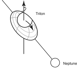
Figure 1 – High Viscosity Wander
On the other hand, its stiffness might be low, so that any size cap might be expected to wander toward the tidal bulge axis (see Figure 2).
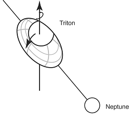
Figure 2 – Low Viscosity Wander
In this case, the axis of wander passes through the equator from the leading side to the trailing side; rotation about this wander axis would not disturb the cratering statistics. Polar wander may explain the bright southern hemisphere: this is the pole which is wandering toward the equator, while the other hemisphere tilts out of view. In any case the “permanent” polar caps may be geologically very young. Polar wander may also take place on Pluto, due to its obliquity oscillations and perihelion-pole geometry. However, Pluto is probably not experiencing any wander at present. The Sun has been shining strongly on the poles over the last million years, so that volatiles migrate to the equator, stabilizing the planet against wander. Spacecraft missions to Triton and Pluto which measure how flat the objects are could give information about the accumulation of volatiles at the poles. Such information is best obtained by measuring gravity and topography from orbiters, as was done for Mars with the highly successful Mars Global Surveyor.
Based on a paper by Rubincam, D.P. Polar wander on Triton and Pluto due to volatile migration, Icarus, 163, 469-478, 2003.
ORBITAL-ROTATIONAL-CLIMATIC INTERACTIONS / PLANETARY GEOLOGY &
GEOPHYSICS
A Solar System Survey of Forced Librations in Longitude
Bruce Bills (Bruce G. Bills@nasa.gov)
Forced librations in longitude are periodic variations in the spin rate of a planetary body arising from gravitational interactions with an orbital partner. The analytic theory we have developed allows us to examine expected amplitudes of forced librations for bodies occupying a wide range of spin states: non-resonant, non-synchronous but resonant (e.g. Mercury), and synchronous. The theory has been applied to 33 solar system bodies including the planets, many planetary satellites, and Eros.
This study has been motivated by the recognition that the rotational response of a planetary body to external gravitational perturbations can be used to probe its internal density structure. Thus observations of forced libration amplitudes can provide a method for a remote determination of a body’s radial mass distribution. Comparison of such observations with our calculated libration amplitudes (where we have assumed a uniform density, rigid body) should allow for discrimination of complex, radial density distributions from simpler, near homogeneous cases. The phase and amplitude of librations for a body with density stratifications will be much different than those exhibited by a homogeneous, rigid body. Calculations of expected librations can supply amplitude estimates helpful in determining whether librational dissipation may be important, and in identifying the likelihood of detecting librations observationally.
Our approach makes several simplifications. While a rotating body in the presence of a gravitational partner will exhibit changes both in spin rate, and spin direction if the orbit-normal and spin vector are not parallel, we assume zero obliquity so that gravitational torques excite only changes in spin rate. This method will not be as accurate for bodies with large obliquities, such as Earth. The time scale over which forced librations operate are sufficiently short compared to the time scale for orbital evolution that we assume fixed Keplerian ellipses for the orbits.
Librational amplitude estimates are derived by
expressing the behavior of the system as a balance between external
torques,
and the response of the body. We write the torque as a function of
several
parameters: the body’s departure from spherical symmetry, expressed as
the
moment difference
 ,
,
the angular orientation q of its
principal axis a, measured from an inertially fixed reference
direction,
and the body’s orbital position expressed as true anomaly f,
which is
angular distance from periapse. In terms of those parameters, we write
the
rotational response to the torque as

If we assume that the unperturbed state of the
body is
steady rotation, then the angle ![]() can
be decomposed into a steady component pM,
and a small libration angle g, where p is the ratio of
the body’s rotation rate to its orbit rate, and M is mean
anomaly.
We then expand orbital position as a Fourier series in eccentricity (e),
and mean anomaly (M), resulting in a Fourier-like series
representation
of the forcing that is periodic in time.
can
be decomposed into a steady component pM,
and a small libration angle g, where p is the ratio of
the body’s rotation rate to its orbit rate, and M is mean
anomaly.
We then expand orbital position as a Fourier series in eccentricity (e),
and mean anomaly (M), resulting in a Fourier-like series
representation
of the forcing that is periodic in time.
The librational response ![]() will
take the same form as the forcing, and equating coefficients between
the
expected form of
will
take the same form as the forcing, and equating coefficients between
the
expected form of ![]() and
the
series expansion for the forcing yields the series solution for forced
librations
and
the
series expansion for the forcing yields the series solution for forced
librations


where Cq,
and Sq are Cayley coefficients. 
Application of this series solution to solar system bodies shows that the dominant libration amplitude always occurs at frequency 2(p-1)n or semi-diurnally as seen from a reference frame centered on the torquing primary. For a rigid body, the angular amplitude for the forced librations of a synchronous rotator can be approximated as
g = 6 s e
and for a rigid, non-synchronous rotator, the
libration
angular amplitude can be estimated by

ORBITAL-ROTATIONAL-CLIMATIC INTERACTION / PLANETARY GEOOGY &
GEOPHYSICS
Gravitational Core-Mantle Coupling and Length-of-Day
David Rubincam (David.P.Rubincam@nasa.gov)
The tides are slowing down the rotation of the Earth, overwhelming a smaller positive acceleration from postglacial rebound. According to historical records such as ancient and medieval observations of solar eclipses, the signal from these two secular effects appears to be significantly corrupted by a source (or sources) of an episodic or perhaps periodic nature operating on a 1000 year timescale. This non-secular source causes accelerations which are the same order-of-magnitude as the tides, ~6 ´10-22 s-2. Coupling between the liquid outer core of the Earth and the mantle has long been a suspected reason for changes in the length-of-day. Research heretofore has been aimed at viscous, electromagnetic, and topographic coupling at the core-mantle boundary, mostly on the decadal timescale, and at gravitational coupling not related to the problem treated here.
The present investigation focuses on the gravitational coupling between the density anomalies in the convecting liquid outer core and those in the mantle and crust as a possible cause for the observed non-secular acceleration on the millenial timescale. (Hereafter "mantle" is used as a shorthand for "mantle and crust.") The basic idea is as follows. There are density inhomogeneities caused by blobs circulating in the outer core like the blobs in a lava lamp; thus the outer core's gravitational field is not featureless. Moreover, these blobs will form and dissipate somewhat randomly. Thus there will be a time variability to the field. These density inhomogeneities will gravitationally attract the density anomalies in the mantle.
The outer core and mantle may not be in a state of gravitational equilibrium if the blobs form and dissipate faster than either the outer core or mantle can react to achieve a state of zero torque. In other words, the mantle and outer core may always be in a state of disequilibrium due to the stochastic nature of "core weather." The outer core and mantle will try to align with each other to make the torque between them zero; but before this can happen, the gravitational field of the outer core may change, so that the core and mantle never catch up with each other. Hence it may be that the outer core is forever torquing the mantle, changing its rotation state and perhaps producing the observed non-secular acceleration and changing the length-of-day. By action-reaction the outer core will also change its rotation state.
A quantitative calculation indicates that the gravitational torque on the mantle from the liquid core may be sufficient to explain the accelerations and decelerations in the Earth’s rotation on the 1000 year timescale. The corresponding torque by the mantle on the core may also explain the westward drift of the magnetic field of 0.2° per year. Gravitational core-mantle coupling would stochastically affect the rate of change of the Earth’s tilt by just a few per cent. Its contribution to polar wander would only be about 0.5% the presently observed rate of 10 centimeters per year.
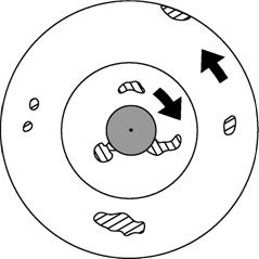
Figure 1. Blobs in the liquid outer core attract density inhomogeneities in the mantle, torquing the mantle.
This article is based on a paper published by Rubincam,. D.P., Gravitational core-mantle coupling and the acceleration of the Earth, J. Geophys. Res., 108, B7, 2338, doi: 1029/ 2002JB002132, 2003.
PLANETARY GEOLOGY & GEOPHYSICS / CRUSTAL DEFORMATION
Satellites Seek Gravity Signals for Probing the Earth’s Interior
Han-Shou Liu (Hanshou@core2.gsfc.nas.gov)
For the past 4 decades, models of mantle convection have made remarkable advances. However, the global seismotectonic stresses in Earth’s interior due to mantle convection are yet to be determined. The problem is that no one has been able to come up with a satisfactory scenario that must characterize the deformation stresses in Earth which can cause earthquakes and create tectonic features.
The fundamental problem of the deformation of the Earth involves stress conditions on the base of the crust caused by mantle convection. Convection-generated stresses can be inferred from satellite gravity models. The new gravitation model EGM96 has improved spherical harmonics of the model to degree and order of 360. In order to provide insights into the origin of earthquakes and prove the existence of the mesospheric plates which range in depth from 100 km to 300 km, Liu et al. (2003) have developed a global stress pattern from satellite gravity models as shown in Fig.1, in which the length of the arrows represents the magnitude of the stress strength. Figure 1 seems to suggest a stress origin of shaping our world. Large earthquakes are shown to be restricted in the global belts of stress concentration. It is confirmed that the boundaries of the Hawaiian, Tristan and Icelandic mesoplates as defined by Pilger (2003) are subjected to large stress concentration.
Satellite detected stress concentrations are particularly intense in the ring of fire around the Pacific as indicated by strong convergence of arrows. These are the
The stress fields thus derived also have possible applications in earthquake prediction studies. The US/China joint earthquake prediction program beginning in 1981 has presented a thorough study of the relationship between gravity variations and seismotectonic stress changes under the Beijing-Tianjin-Tangshan-Zhangjiakou (BTTZ) region in
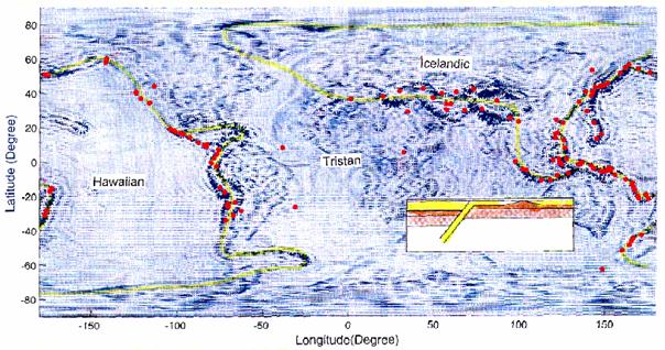
Figure 1. This equatorial equidistant seismotectonic stress map as inferred from satellite gravity signals up to the 150 harmonic degree shows approximate boundaries of the Hawaiian, Tristan and Icelandic mesoplates (200 km below Earth’s surface). Formation of the three mesoplates has provided a framework for resolving a decades-old controversy (Pilger 2003) and explaining these destructive tectonic stresses as the origin of the 131 Ms > 7.0 earthquakes during 1977 to 2000.
Inset: Carton section of lithoplates, asthenosphere and mesoplates.
Reference:
Liu, H. S., R. Kolenkiewicz, J. L. Li and J. Z. Chen , Satellite detection of the convection generated stresses in Earth, Recent Research Developments in Geophysics, 5, 117-137. 2003.
Pilger, R.H., Mesoplates: Resolving a decades-old controversy, EOS, Transactions, AGU, 84, 51, 573-576, 2003.Pilger, R.H., Geokinematics: prelude to geodynamics, Springer-Verlag, pp.338, 2003.
ORBITAL-ROTATIONAL-CLIMATIC INTERACTIONS / PLANETARY GEOLOGY & GEOPHYSICS
Obliquity, Precession, and Geomagnetism
Han-Shou Liu (Hanshou@core2.gsfc.nas.gov)
The environment of the Earth is surrounded by a magnetic field which is believed to originate in the flow of the Earth’s fluid core. Although specific heat sources in the Earth’s core may produce convective motions which drive the dynamo, the dynamo process in the core which causes fluctuations of the geomagnetic intensity is a scientific mystery. Recently, geophysicists have integrated 33 records of geomagnetic intensity into a composite curve spanning the last 800 kyr (Sint-800). They have shown that the Earth’s magnetic intensity fluctuated on a variety of time scales. The periods of their geomagnetic intensity fluctuations are almost identical with that of the precession modulation of the obliquity as obtained by Liu et al, (2003). This suggests that the orbital-rotational coupling effect on the convection of the Earth’s liquid core may be the geodynamo that generates the planet’s magnetic intensity fluctuations.
In order to understand the Earth’s orbital and rotational motion as the cause of geomagnetism, it is necessary to introduce some fundamental notions of celestial mechanics. Recent advances in celestial mechanics have led to precise results of precession modulation in the frequency of the Earth’s obliquity, which is a crucial orbital parameter associated with the regeneration of the geodynamo. The frequency spectrum of the Earth’s obliquity is shown in Fig. (a). It is calculated using gravitational attractions of the Moon, planets and Sun on the equatorial bulge of the Earth. The power spectrum, which peaks at 250-, 100-, 50-, 41-, 32- and 26-kyr, may have physical implications with regard to intensity changes in the geomagnetic field.
Recent advances in geomagnetic dating techniques have led to precise records of the relative intensity of geomagnetism at numerous field sites. The spectrum of the Sint 800 record is shown in Fig, (b). It shows that the power spectrum peaks at 250-, 100-, 50-, 41-, 30-, and 26-kyr, which seems to mimic the frequency spectrum of the obliquity in Fig. (a). Therefore, the most important feature which the orbital imprint may be recognized in geomagnetic records is probably the precession modulation of the Earth’s obliquity.
There is almost certainly significant convection in the outer core of the Earth, involving considerable energy transfer. This study shows that an external orbital effect could steer the form of the time variation of the geodynamo. The clear and strong correlation between the two spectra in Figures (a) and (b) seems to suggest that precession modulation of the obliquity frequency may be the primary power source which injects significant energy into the core to power the dynamo and dominates over direct thermal effect.
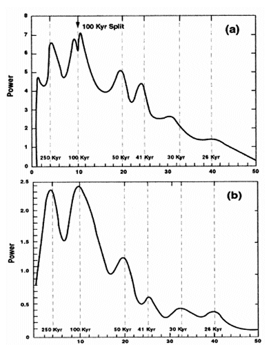
Figure 1. Power spectra are almost identical: (a) obliquity modulation spectrum of the precession over the past 800 kyr. (b) Virtual axial dipole moment (VADM) spectrum over the past 800 kyr (Sint 800).
Reference: Liu, H.S., R. Kolenkiewicz, and C. Wade, Orbital noise of the Earth causes intensity fluctuation in the geomagnetic field, Fluctuation and Noise Letters, 3,1, 63-72, 2003.
Geomagnetic Probing of Core Geodynamics
Coerte Voorhies (Coerte.V.Voorhies@nasa.gov)
As Earth’s magnetic field weakens, our magnetic shield against the onslaught of the solar wind thins. And the field strength needed to fend off the magnetized solar plasma is decreasing, just as the delicate complexity of our vulnerable electro-technical systems is increasing at unprecedented rates. So a working group of distinguished scientist from across the nation has asked NASA’s Solid Earth and Natural Hazards program a key question: What are the dynamics of Earth’s magnetic field and its interactions with the Earth system?
Some answers to part of this question come from studies of the core geodynamo, a dynamical system as complicated as weather and climate, yet buried deep beneath 1800 miles of rocky mantle. Electric current flowing in Earth’s metallic core is the main source of the main field, but it is weakening faster than expected from the small electrical resistivity of the metal. According to one theory, as Earth cools over geologic time, the solid iron inner core freezes from the molten outer core. This liberates latent heat and buoyant slag which rise, stirring the outer core to motion at speeds of several miles per year. Whatever causes core fluid motion, dynamo action transforms kinetic energy of the motion into magnetic energy of the field. Some of this energy emerges as our largely dipolar magnetic shield. But sometimes the transformation may go the other way, with the core running like a motor instead of a generator. This may accelerate core motions, weaken our shield, and perhaps drive the main axial dipole field to zero and beyond - to reversed polarity.
Paleomagnetic studies of crustal rocks magnetized in the geologic past reveal that polarity reversals have occurred many times during Earth’s history. Computer simulations of core field & flow, including effects of gravitational, pressure, Coriolis, magnetic and viscous forces, suggest how this might happen in detail. And space-based measurements of the real, time-varying magnetic field help constrain estimates of the speed and direction of fluid flow by the top of Earth’s core.
Core flow estimates often omit small scale features, less than about 600 miles across, which are not easily resolved from observed, broad scale changes in the field. Some estimates also neglect magnetic forces by the top of the core compared with other forces. Of course, when it comes to the scale of the flow and the strength of magnetic forces in a liquid metal hidden by 1800 miles of rock, doubts abound.
At LTP, we have developed and applied methods to test both the hypothesis of narrow scale flow, and that of a dynamically weak magnetic field, by the top of Earth’s core. Using two completely different methods, we have shown these hypotheses lead to a specific theoretical form for the spectrum of Earth’s main magnetic field and a different form for the spectrum of its rate of change. Much as a prism separates light into its spectrum, from long wavelength red to short wavelength blue light, geophysicists use the digital prism of spherical harmonic analysis to separate the magnetic field into its spectrum, from long to short wavelength fields. And we do this for the rate of change of the field as well.
To test a hypothesis, the implied theoretical spectrum is fitted to an observational spectrum. This yields an estimate of the radius of Earth’s core and its uncertainty. If the estimate agrees with the established value, determined by independent seismological techniques, then the hypothesis passes the test. The weak field and the narrow scale flow hypotheses each pass key tests, both separately and together. Recent analysis of data from the Danish Geomagnetic Research Satellite Ørsted, however, suggests the core flow may have become broader in scale, or better organized, in just the past 20 years.
For further information, including how compact eddies in a fluid conductor cause magnetic field changes over all scales, and how the magneto-geostrophic vorticity balance constrains kinetic-to-magnetic energy conversion atop the core geodynamo, see the paper, “Narrow scale flow and a weak field by the top of Earth’s core: evidence from Ørsted, Magsat, and secular variation” by Coerte V. Voorhies, to appear in the American Geophysical Union’s Journal of Geophysical Research - Solid Earth.
Abstract: To test two hypotheses against seismology, the Ørsted Initial Field Model is used to estimate the radius of Earth’s core by spectral methods. The model coefficients are used to compute the mean square magnetic flux density in spherical harmonics of degree n on the reference sphere of radius a = 6371.2 km, which is an observational spectrum Rn. The theoretical spectrum tested, {Rnc} = K(n+1/2)[(n(n+1)]-1(c/a)2n+4, is obtained from the hypotheses of narrow scale flow and a dynamically weak magnetic field near the top of Earth’s core; it describes a low degree, core-source magnetic energy range. Core radius c and amplitude K are estimated by fitting log-theoretical to log-observational spectra at low degrees. Estimates of c from Rn of degrees 1 through N vary between 3441 and 3542 km as N increases from 4 to 12. None of these estimates differ significantly from the seismologic core radius of 3480 km. Significant differences do occur if N exceeds 12, which is consistent with appreciable non-core, crustal source fields at degrees 13 and above, or if other spectral forms are assumed. Similar results are obtained from the 1980 epoch Magsat model CM3.
One way to deduce {Rnc} uses an expectation spectrum for low degree secular variation (SV) induced by narrow scale flow near the top of Earth’s core, {Fnc} = Cn(n+1/2)(n+1)(c/a)2n+4. The value of c obtained by fitting this form to the mean observational SV spectrum from model GSFC 9/80 is 3470 + 91 km, also in accord with seismologic estimates. This test of the narrow scale flow hypothesis is independent of the weak field hypothesis. The agreement between SV, Magsat, Ørsted and seismologic estimates of core radius means the hypotheses pass these tests. Additional tests are described.
Satellite-Altitude-Magnetic
Data over the Mineralized Region of
Patrick Taylor (Patrick.Taylor@nasa.gov)
Satellite
altitude (400 km) and aeromagnetic anomaly data have been analyzed over
the
Kiruna,
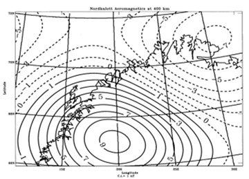
Figure 1. Nordkalott aeromagnetic data upward continued to 400 km altitude. Contour interval 1 nT with solid contour lines representing positive values, dashed the negative and dotted the zero contour.
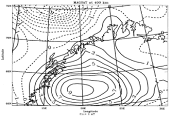
Figure 2. Magsat magnetic anomaly map computed at 400 km altitude. Contour interval 1 nT with solid contour lines representing positive values, dashed the negative and dotted the zero contour.
It is particularly noteworthy that the positive magnetic anomalies in both the satellite and upward continued aeromagnetic data are coincident and have the same value indicating that both data sets have the same zero-reference level. We can interpret this agreement to indicate that these two data sets are sensing the same anomalous magnetized body.
A map of the major fracture zone of this region (Billstrom et al.,1997) was superimposed on the Magsat anomaly map (Figure 3).
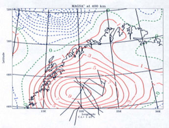
Figure 3. Data of Figure 2 with the fracture pattern of Billstrom et al. (1997) superimposed. Contour interval 1 nT with solid contour lines representing positive values, dashed the negative and dotted the zero contour.
The
intersection of the major fracture zones lies slightly to the northeast
of the
Magsat anomaly center. It is, therefore, interesting to speculate that
the
anomalous magnetic mass causing the satellite-altitude anomaly is deep
seated
and related to the fracture zone pattern. It has been proposed
that major
lineaments played a role in the emplacement of the ore deposits of
This work based on a paper by P.T. Taylor and J.J. Frawley, “Satellite altitude magnetic data and the search for mineral resources - the Kiruna region, Sweden, in Global Tectonics and Metallogeny, vol. 8, p 165-178, 2003.
References.
Billstrom, K., Frietsch, R., Perdahl, J. -A., (1997): Regional variations in the Pb isotopic compositions of ore galena across the Archaean-Proterozoic border in northern Sweden.- Precambrian Research, Vol. 81: 83-99.
Balloon Geomagnetic Survey at Stratospheric Altitudes
Katherine Nazarova (katiah@geomag.gsfc.nasa.gov)
In
1996 the intensity of the geomagnetic field was measured by a balloon
which
traveled for 6000 km at an altitude of 30 km across
Rocks in the crust of the Earth create these magnetic anomalies. The higher the observation is above the surface of the Earth the smoother these appear because the shorter wavelengths are attenuated with elevation faster than the longer wavelengths. Because of this effect it is impossible to positively identify anomalies measured on the surface with those recorded at satellite altitude (about 300 km). The balloon data, at an intermediate altitude of 30 km, was thought to offer the possibility to compare data from three altitudes.
Each type of data has its own characteristics. Not all surface measurements (usually made by aircraft) are taken with the same altitude or line spacing. Satellite data was taken from the latest and most advanced geomagnetic field model (CM3), as expressed by a spherical harmonic series. This series has a finite length, which limits the spatial resolution of the data. These different characteristics prevented a simple comparison with balloon observations or with a spectral analysis of the data sets.
However the balloon observations revealed large anomalies with amplitudes of 100 to 200 nT and wavelengths of 250 to 750 km which were not expected (see Figure 1).
These
anomalies extend all across the Siberian
platform, from
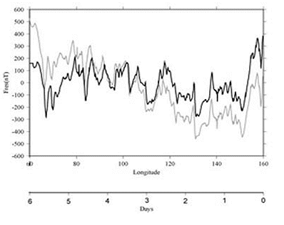
Figure 1 . Magnetic profile with CM3e (n<15) removed from observed data (grey line) and with CM3e (n<15) and straight line fit removed from observed data (black line) versus longitude and time.
A large
anomaly is over the western side of the
Submission of the End-to-End Simulator Package for swarm
Michael Purucker (purucker@geomag.gsfc.nasa.gov)
As part of a phase A study in the Earth Explorer Opportunity mission series, ESA organized the development of an End-to-end simulator for the swarm mission, one of three missions selected in 2002 for detailed study. Personnel of the Geodynamics Branch have been leaders in this effort, with T. Sabaka’s Comprehensive model of the near-Earth magnetic field serving as the centerpiece of this effort. The mid-term report of the simulator was accepted by ESA in November of 2003, and the final report will be presented in February of 2004. M. Purucker (RITSS) is a member of ESA’s Mission Advisory Group for swarm, and is integrating the results from the simulator into a report to be submitted to ESA and it’s advisory committees in March of 2004. The final decision on whether to proceed with the development of swarm will be made in mid-year.
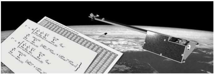
Figure 1. One of the proposed swarm satellites, juxtaposed against some of the formalisms used for representing the near-Earth magnetic field that are being used in the End-to-end simulator.
PLANETARY GEOLOGY & GEOPHYSICS
Visible and Buried Impact Basins on Mars and the Demise of the Global Magnetic Field
Herbert Frey (Herbert.V.Frey@nasa.gov)
Buried impact basins on Mars revealed by their subtle topographic signature in Mars Orbiter Laser altimeter data have provided important constraints on the early evolution of Mars. The buried lowland crust, below the smooth and sparsely cratered plains, are now known to be extremely old, likely as old as the exposed highlands of Mars. The highlands are also older than thought, at least in the sense that there too we find buried impact basins suggesting a total crater retention age greater than previously believed
A recent survey of large “Quasi-Circular Depressions” larger than 200 km in diameter provides additional constraints on these age relations as well as on the question of when the global magnetic field may have shut off. Among these QCDs there are about a dozen very large basins (D>1000 km), of which two (Daedalia and Ares) are extremely subtle and which appear to be the oldest of the population, based on the
anomalies within their main rings. By contrast, the freshest
large impact basins
(
If, as has been suggested by others, the lack of anomalies in the freshest large basins is because those impacts occurred after the main global field had shut off, it appears the field was still present when the much earlier Daedalia and Ares basins formed. We suggest the field turned off slightly before or at about the time the intermediate age, “lowland-making” basins formed, at an N(200) crater retention age of ~3.5. It is interesting to ask if the formation of the lowlands may be related to the demise of the global magnetic field.
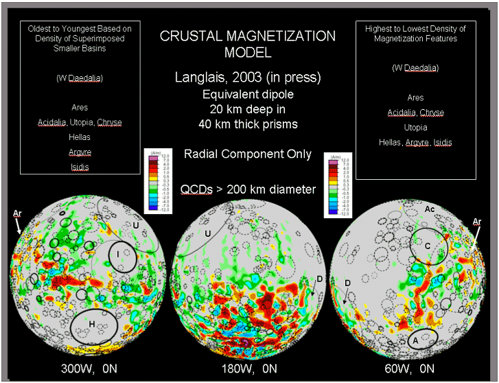
Figure 1: Magnetization model from Langlais compared with distribution of visible and buried impact basins. Fresh large basins Hellas (H), Isidis (I) and Argyre (A) have no strong magnetic features and may have formed after the main magnetic field died. Ares (Ar) and Daedalia (D) do have strong anomalies and probably formed before the global field vanished. The “lowland-making” basins Acidalia (Ac), Chryse (C) and Utopia (U) have only a few weak anomalies, and so may have formed just after or about the same time as the field shut off.
PLANETARY GEOLOGY & GEOPHYSICS
GRIDVIEW: Software for Exploring Mars Topography and More
James H. Roark (roark@core2.gsfc.nasa.gov)
The Geodynamics branch continues to add enhancements to a scientific visualization software tool called GRIDVIEW (http://core2.gsfc.nasa.gov/gridview/) written in the Interactive Data Language (IDL) that can be used by researchers and students to study and explore the topography of Mars. The tool can be used to visualize and study any grided data, but was specifically designed to study the topographic data products of the Mars Orbiter Laser Altimeter (MOLA). GRIDVIEW provides various tools to view, explore, measure, and produce high quality graphics. It has become a basic tool in the study of visible and buried basins on Mars, investigations of the dichotomy boundary, examination of the Medusa Fossae formation, calculation of sediment fill in large craters, and measurement of volcano and crater geometry.
With GRIDVIEW, students or anyone else can use the same data and tools that are currently being used by planetary scientists and geologists at NASA to make new and exciting discoveries. High School and undergraduate students have been successfully using this tool to analyze the topographic characteristics of Mars and Earth in support of many research projects.
A major factor in the accessibility of GRIDVIEW changed over the past year when Research Systems Inc. (RSI, http://www.rsinc.com ), the vendor of IDL, modified their licensing scheme. RSI now provides a free IDL virtual machine application that allows users to run precompiled IDL code. This means that users can download GRIDVIEW and run it without any cost. This removes one of the major roadblocks in getting GRIDVIEW setup in classroom or educational settings.
Standard Features of GRIDVIEW:
Latitude / Longitude / Value Tracking
Global Rotation and Zooming
Color Stretching and Contouring
Profile plotting
Basin / Crater Measurement and Plotting
Multiple Format Data Input
Multiple Format Image Output
Distance / Height / Slope Measurement
Shaded Relief View
Overlay other Data Contours
Contour on Geologic Base Map
Area and Volume calculation tools
With IDL programming help from National Space Club Scholar, Christine Masuoka, we were able to add the following features in 2003:
Modified area calculation code for greater accuracy
“Snap to” vertical and horizontal function in the profile tool
Annotation widget in the profile tool
Profile area calculation capabilities in the profile tool
Interactive 3D perspective view with fly through capabilities
Additional image output formats
Reorganized tools menu
Improved shaded relief routine
Improved Save/Load View option
Ability to modify spherical dimensions, enabling accurate measurements of data from other planets or circular objects
Color tables and contouring routines for magnetic and magnetization data sets
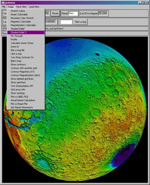
Basic GRIDVIEW display with the tools pull-down menu.
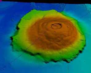
Perspective view of Olympus Mons volcano with a profile location mark.
PAPERS PUBLISHED, ACCEPTED AND SUBMITTED IN 2003
Alphabetical by First 921 Author
PUBLISHED
Comstock, R.L., and B.G. Bills, A solar system survey of forced librations in longitude, J. Geophys. Res. Planets, 108, 5100,2003.
Cohen, S.C. and D.J. Darby, Tectonic plate coupling and elastic thickness derived from the inversion of geodetic data using a steady-state viscoelastic model: Application to southern North Island, New Zealand, Journal of Geophysical Research, 108(B3), 10.1029/2001JB01687, 2003.
Haugerud, R., D.J. Harding, S.Y. Johnson, J.L. Harless, C.S. Weaver, and B.L. Sherrod, High-resolution topography of the Puget Lowland, Washington - A bonanza for earth science, GSA Today, 13(6): 4 – 10, 2003.
Carabajal, C.C., D.J. Harding, J.L. Bufton, S.B. Luthcke and D.D. Rowlands, ICESat Geolocation and Land Products Validation: Laser Altimetry Profile and Waveform Matching, ISPRS workshop on 3D mapping from InSAR and Lidar, Portland OR, June 17-19, 2003.
Liu, H. S., R. Kolenkiewicz and C. Wade, Orbital noise of the Earth causes intensity fluctuations in the geomagnetic field, Fluctuation and Noise Lett., 3, L63-L72, 2003.
Liu, H. S., R. Kolenkiewicz and C. Wade, Insolation pulsation theory for atmospheric greenhouse –gas concentrations, Recent Research Developments in Atmospheric Sciences, 3, 57-79, 2003.
Liu, H. S., R. Kolenkiewicz, J. L. Li and J. Z. Chen , Satellite detection of the convection generated stresses in Earth, Recent Research Developments in Geophysics, 5, 117-137. 2003.
Lowman, P.D., Space Exploration and Plate Tectonics, Space Times, v. 42, no. 4, July/August 2003, p. 4-9. 2003.
Lowman, P.D., Life in the Universe, The Science Teacher, v. 70, no. 8, p. 40-45. November. 2003.
Whaler, K., and M. Purucker, Martian magnetization-preliminary models, The Leading Edge, 22(8), 763-765, August, 2003.
Vennerstrom, S., N. Olsen, M. Purucker, M.H. Acuna, and J.C. Cain, The magnetic field in the pile-up region at Mars, and its variation with the solar wind, Geophy. Res. Lett., 30(7), 1369, doi: 10.1029/2003GL016883, 2003.
Stauning, P., H. Luhr, P. Ultre-Guerard, J.
LaBrecque,
M. Purucker, F. Primdahl, J.L. Jorgensen, F. Christiansen, P.
Hoeg, K.B
Lauritsen, (editors). OIST-4 Proceedings, 4th Oersted International
Science
Team Conference, 2003, DMI Scientific Report 03-09,
Purucker, M., T. Sabaka, N. Olsen, and S. Maus, How have Oersted, CHAMP, and SAC-C improved our knowledge of the oceanic regions, OIST-4 Proceedings, 4th Oersted International Science Team Conference, 89-95 (2003).
Purucker, M. and N. Olsen, Modeling of the Earths magnetic field and its variation with Oersted, CHAMP, and Oersted-2/SAC-C, OIST-4 Proceedings, 4th Oersted International Science Team Conference, 319-327 (2003).
Purucker, M. ,Review of: Surface Exploration Case Histories: Applications of Geochemical, Magnetic, and Remote Sensing Methods to Exploration, Field Development, and Production, edited by Dietmar Schumacher and Leonard LeSchack, ISBN, AAPG / SEG, Tulsa, 2002, The Leading Edge, volume 22, no.8, pages 790 and 800, 2003.
Rubincam, D. P., Polar wander on Triton and Pluto due to volatile migration, Icarus, 163, 469-478, 2003.
Rubincam, D. P., Gravitational core-mantle coupling and the acceleration of the Earth, J. Geophys. Res., 108, B7, 2338, doi:1029/2002JB002132, 2003.
Sanchez, B. V., D. D. Rowlands, R. M. Haberle, and J. Schaeffer, “Atmospheric rotational effects on Mars based on the NASA Ames general circulation model”, J. Geophys. Res., Vol. 108, NO. E5, 5040, doi:10.1029/2002JE001984, 2003.
Kim, H.R., R.R.B. von Frese, P.T. Taylor, J.W. Kim and C. H. Park, Utility of satellite magnetic observations for estimating near-surface magnetic anomalies, OIST-4 Proceedings, 4th Oersted International Science Team Conference, p. 83-86, 2003.
Taylor, P.T., H.R. Kim, R. R.B. von Frese, L.V. Potts and J.J. Frawley, Satellite-Altitude Geopotnetial study of the Kursk magnetic Anomaly (KMA), OIST-4 Proceedings, 4th Oersted International Science Team Conference, p. 95-98, 2003.
Taylor, P. T., J.J. Frawley, H.R. Kim, R, von Frese and J.W. Kim, Comparing Magsat, Ørsted and CHAMP crustal magnetic anomaly data over the Kursk Magnetic Anomaly, Russia, First CHAMP Mission Results for Gravity, Magnetic and Atmospheric Studies, Eds. C. Reigber, H. Luhr and P. Schwintzer, Springer, p. 302-308, 2003.
von Frese, R.R.B., H. R. Kim, P. T. Taylor and J.W. Kim, CHAMP, Øersted, and Magsat Magnetic Anomalies of the Antarctic Lithosphere, First CHAMP Mission Results for Gravity, Magnetic and Atmospheric Studies, Eds. C. Reigber, H. Luhr and P. Schwintzer, Springer, p. 309-314, 2003.
Taylor, P.T. and J.J. Frawley, Satellite altitude magnetic data and the search for mineral resources-The Kiruna region, Sweden, Global Tectonics and Metallogeny, vol. 8, nos. 1-4, p. 165-178, 2003.
Kutina, J. and P.T. Taylor, Satellite altitude magnetic anomalies implications for mineral exploration-A review, Global Tectonics and Metallogeny, vol. 8, nos. 1-4, p.89-106.
Kutina, J. and P.T. Taylor, Introduction, Global Tectonics and Metallogeny, vol. 8, nos. 1-4, p.3-8, 2003.
Taylor, P.T., Review of “Surface Exploration Case Histories: Applications of Geochemical, Magnetic and Remote Sensing Methods to Exploration, Field Development and Production, D. Schumacher and L. LeSchack (eds.), The Leading Edge, vol. 22, 790-800, 2003.
Voorhies, C.V., Narow-scale, weak field flow at the top of Earth’s core: evidence from Oersted, Magsat and secular variation (SV), OIST-4 Proceedings, 4th Orsted International Science Team Conference, p. 59-63, 2003.
Egbert, G.D., R.D. Ray, and B.G. Bills, Numerical modeling of the global semidiurnal tide in the present day and in the last glacial maximum, J. Geophys. Res. Oceans, 2003 (in press).
Parker, G.G., D.J. Harding, and M.L. Berger, A portable lidar system for rapid determination of forest canopy structure, Journal of Applied Ecology, 2003. (in press).
Fox Maule, C., M. Purucker, and N. Olsen, Magnetic crustal thickness in Greenland from CHAMP and Oersted data, 2nd CHAMP Mission Results for Gravity, Magnetic and Atmospheric Studies, 2003 ((in press).
Langlais, B., M. Purucker, and M. Mandea, The crustal magnetic field of Mars, Jour. Geophys. Res-Planets, accepted and in press, 2003 (in press).
Nazarova, K.A., Y. Tsvetkov, J. Heirtzler and T. Sabaka,
Balloon geomagnetic
survey at stratospheric altitudes, 2nd CHAMP
Nazarova, K.A., Magnetic petrology database for interpretation of satellite magnetic anomalies, 2nd CHAMP Mission Results for Gravity, Magnetic and Atmospheric Studies, 2003 (in press).
Rubincam, D. P., Black body temperature, orbital elements, the Milankovitch precession index, and the Seversmith psychroterms, Theor. Appl. Climatol., 2003 (in press).
Sauber, J., and B. Molnia, Ice Mass Fluctuations and Fault Instability in Tectonically Active Southern Alaska, Global and Planetary Change, Ice Sheets and Neotectonics, topical issue, 2003 (in press).
Taylor, P.T. and G.L. Johnson, Magnetic Signature for the Pole-of-Opening of the Canada Basin, Special Volume in honor of A.V. Karasik, to be published by the St. Petersburg, Russia Marine Geology Group, 2003 (in press).
Voorhies, C.V., Narrow-scale flow and a weak field by the top of Earth's core: evidence from Oersted, Magsat, and secular variation, J. Geophys. Res., 2003, (in press).
SUBMITTED
Bills, B.G.,
K.D. Adams, and S.G. Wesnousky, Viscosity structure of the crust and
upper
mantle in western
Bills, B.G., and R.L. Comstock, Forced librations in longitude for non-resonant rotators: Application to Venus, Earth, and Mars, Icarus, 2003 (submitted).
Bills, B.G., Free and forced obliquities of the Galilean satellites of Jupiter, Icarus., 2003 (submitted)
Bills, B.G., Variations in the rotation rate of Venus due to orbital eccentricity modulation of solar tidal torques,
J. Geophys. Res. Planets, 2003 (submitted).
Bills, B.G., and R.L. Comstock, Forced obliquity variations of Mercury, J. Geophys. Res. Planets, 2003 (submitted).
Birkett, C.M., D. Alsdorf, and D.J. Harding, Hydrological applications of remote sensing: Surface state - river and water body stage, width and gradient from satellite radar altimetry, interferometric SAR, and laser altimetry, in Encyclopedia of Hydrological Sciences: Remote Sensing, John Wiley and Sons, 2003. (submitted)
Purucker, M. “Long-wavelength anomalies”, “Magsat” and “R.A. Langel” articles in Encyclopedia of Geomagnetism and Paleomagnetism, D. Gubbins and E. Herrero-Bervera (eds), 2003 (submitted)
Sabaka, T., N. Olsen, and M. Purucker, Extending Comprehensive Models of the Earths Magnetic Field with Oersted and CHAMP data, Geophys. J. Int., submitted, 2003 (submitted)
Taylor, P.T.
and six others, Effect of varying crustal thickness on CHAMP
geopotential data,
2nd CHAMP
Kim, H.R., L. R. Gaya-Pique, R. R. B. von Frese, P. T. Taylor and J. W. Kim, CHAMP magnetic anomalies of the Antarctic crust, 2nd CHAMP Mission Results for Gravity, Magnetic and Atmospheric Studies, 2003 (submitted)
von Frese, H.R., Kim, P.T. Taylor and M.A. Asgharzadeh, Reliability of CHAMP Anomaly Continuations, 2nd CHAMP Mission Results for Gravity, Magnetic and Atmospheric Studies, 2003. (submitted)
Taylor, P.T. and J.J. Frawley, Paleo-pole positions from Martian magnetic data, ICARUS, 2003 (submitted).
PRESENTATIONS AT MAJOR MEETINGS IN 2003
Alphabetical by First 921 Author
34th Lunar and Planetary Science Conference, March 17-21, 2003
R.L. Comstock and B.G. Bills, A solar system survey of forced librations in longitude, CD-ROM abstract #1462, 2003.
B.G. Bills and O. Aharonson, Spatial and temporal patterns of tidal dissipation in synchronous satellites, CD-ROM Abstract #1465, 2003.
Frey, H., Large-diameter visible and buried impact basins on Mars: implications for age of the highlands and (buried) lowlands and turn-off of the global magnetic field, CD-ROM abstract # 1838, 2003.
Solomon, S.C., O. Aharonson, W.b. Banerdt, A.J. Dombard, H.V. Frey, M.b. golombek, S.A. Hauck II, J.w. Head III, C.L. Johnson, P.J. McGovern, P.J. Phillips, D.E. Smith and M.T. Zuber, Why are there so few magnetic anomalies in martian lowlands and basins? CD-ROM abstract #1382, 2003.
Sarid, A.R., H.V. Frey and J. H. Roark, Martian buried basins and implications for characteristics of the burial layer and underlying surface, CD-ROM abstract # 2019, 2003.
Keller, J.W., J.H. Roark, S.E.H. Sakimoto, S. Stockman and H.V. Frey, 3-Dimensional topographic models for the classroom, CD-ROM abstract # 1973, 2003.
Polit, A.T., S.E.H. Sakimoto, D.E. Mitchell and E.B. Grosfils, Geometric properties of possible volcanoes in the south polar region, Mars, CD-ROM abstract # 1514, 2003.
Sakimoto, S.E.H., T.K.P. Gregg, S.S. Hughes and J. Chadwick, Martian plains volcanism in Syria Planum and Tempe Mareotis as analogs to the Eastern Snake River Plains, Idaho: Similarities and possible petrologic contributions to topography, CD-ROM abstract #1740, 2003.
Chase, Z.A.J. and S.E.H. Sakimoto, Thermal modeling of permafrost melt by overlying lava flows with applications to flow-associated outflow channel volumes in the Cerberus Plains, Mars, CD-ROM abstract # 1905, 2003.
Spring EGS-AGU, Nice, France, April 2003
Carabajal, C.C., D.J. Harding, and J.L. Bufton, ICESat Geolocation and Land Products Validation: Laser Altimetry Profile and Waveform Matching, EGS-AGU-EUG Joint Assembly, Nice France, EAE03-A-07791, 2003.
Luthcke, S.B., D.D. Rowlands, D.H. Harding, J.L. Bufton, C.C Carabajal, and T.A. Williams, ICESat laser altimeter surface return geolocation parameter calibration and validation from integrated residual analysis, EGS-AGU-EUG Joint Assembly, Nice France, EAE03-A-13222, 2003.
Birkett, C., D. Harding, D. Emmitt, and E. Rodriguez, Satellite Radar Altimetry and Lidar: Application and Outlook, EGS-AGU-EUG Joint Assembly, Nice France, EAE03-A-04533, 2003.
Purucker, M., J. Connerney, M. Mandea, and G. Hulot, A test for secular variation of the Martian magnetic field.
Sauber, J., and B. Molnia, Ice Mass Fluctuations and Fault Instability in Tectonically Active Southern Alaska, Geophysical Research Abstracts, Vol. 5, 02669, European Geophysical Society, 2003.
Mitchell, D., J. Sauber, D. Harding, C. Carabajal, W. Krabill, S. Manizade, and J. Bufton, Expected ICESat measurement of glacier elevation change, EGS-AGU-EUG Joint Assembly, Nice France, EAE03-A-04398, 2003.
Carver, G., J. Sauber, W.R. Lettis, R. C. Witter, Use of SRTM and Landsat-7 data to evaluate seismic hazards, Kodiak Island, Alaska, Geophysical Research Abstracts, Vol. 5, 04513, European Geophysical Society, 2003.
Taylor, P. T. K. Kis, R.R.B. von Frese, J. Korhonen, G. Wittmann, H.R. Kim, L. Potts, Effect of continental crust thickness variations on satellite-altitude geopotential anomalies, EUG/AGU/EGS Meeting, Geophysical Research Abstracts, vol. 5, EAE03-A-04445, 2003.
Leftwich, T., R. von Frese, L. Potts, D. Roman, P. T. Taylor, Crustal structure of the Iceland Region from spectrally-correlated free-air and terrain gravity data, EUG/AGU/EGS Meeting, Geophysical Research Abstracts, vol. 5, EAE03-A-01280, 2003.
Voorhies, C.V., More on magnetic spectra of Earth and Mars, Session GD8, P0107 (abst. EAE03-A-02987), 2003.
Voorhies, C.V., Stable stratification of the uppermost core during superchrons, Session GD1, P0049 (abst. EAE03-A-07482), 2003.
Voorhies, C.V., Narrow Scale Flow across a weak field by the top of Earth's core: Evidence from Oersted Magsat and SV, Session GD1, P0047 (abst. EAE03-A-02363), 2003.
IUGG Meeting, Sapparo, Japan, July 2003
Suito, H., J.T. Freymueller and S.C. Cohen, 3-D viscoelastic FEM modeling of postseismic deformation
caused by the 1964 Alaska earthquake, southern Alaska,
2nd CHAMP Science Team Meeting, Pottsdam, Germany Sept 1-4, 2003
Nazarova, K.A., Y. Tsvetkov, J. Heirtzler and T. Sabaka, Balloon geomagnetic survey at stratospheric altitudes, 2nd CHAMP Mission Results for Gravity, Magnetic and Atmospheric Studies, 2003 (in press).
Nazarova, K.A., Magnetic petrology database for interpretation of satellite magnetic anomalies, 2nd CHAMP Mission Results for Gravity, Magnetic and Atmospheric Studies, 2003 (in press).
Purucker, M. and K. Whaler, Merging satellite and aeromagnetic data over Europe, the North Atlantic, and the Arctic.
Taylor, P.T., K. Kis, R.R.B. von Frese, J. Korhonen, G. Wittmann, H.R. Kim, L. Potts, Effect of varying crustal thickness on CHAMP geopotential data, 2nd CHAMP Science Meeting, 2003.
von Frese, R.R.B., H.R. Kim, P.T. Taylor, M.F. Asgharzadeh, Reliability of CHAMP Anomaly Continuations, 2nd CHAMP Science Meeting, 2003.
Kim, H.R., L. R. Gaya-Pique, R.R.B. von Frese, P.T. Taylor, J.W. Kim, CHAMP magnetic anomalies of the Antarctic lithosphere, 2nd CHAMP Science Meeting, 2003.
Division of Planetary Sciences Meeting,
Rubincam, D. P.,
Polar wander on Triton due to volatile migration, DPS 35th Annual
Meeting,
Session 23: Planetary Bookends I, paper no. 23.03,
Geological Society of
Frey, H., Buried and visible impact basin distribution on Mars: comparison with magnetization, gravity and crustal thickness models, Paper No. 67-5, 2003.
Harding, D.J., R.A Haugerud, S.Y. Johnson, K.M. Scott, C.S. Weaver, D.M. Martinez, J.C. Zeigler, and D. Latypov, Western Rainier Seismic Zone Airborne Laser Swath Mapping, Geological Society of America Annual Meeting, Paper No. 197-13, Seattle, WA, November 2-5, 2003.
Roark, J.H., J.W. Keller, F. Niepold, S. Sakimoto, S. Stockman, H.V. Frey, 3-dimensional topographic models of geological features in the classroom, Paper No. 46-36, 2003.
Weren, S.L. and S.E.H. Sakimoto, Martian polar volcanoes: Characteristics, implications for effusive vs. explosive eruptions, and differentiation from polar impact craters, Paper No. 67-3, 2003.
Sakimoto, S.E.H., S.S. Hughes, T.K.P. Gregg, J. Chadwick and S.L. Weren, Field constraints on remote sensing shield volcano interpretations: quantitative constraints form the Snake River Plains and extensions to Mars, Paper No. 107-11, 2003.
Carver, G., J. Sauber, W. R. Lettis, R.C. Witter, Paleoseismicity and strain partitioning in the forearc fold and thrust belt of the Kodiak segment, Eastern Aleutian subduction zone, Paper No. 35-8, The Geological Society of American Annual meeting, 2003.
Niepold, F., S. Stockman, S. Sakimoto, J. Keller, J. H. Roark and H.V. Frey, Comparing Earth and Mars: applying UDL to create a middle school science module, Paper No. 213-9, 2003.
Fall AGU Meeting,
McGeary, S., B.G. Bills, and G.
Jimenez,
Shallow Seismic Reflection Imaging of the Salar
Bills, B.G. and R.D. Ray, Long period variations in Jupiter's obliquity and Galilean satellite inclinations: Influence on tidal stress and dissipation, P12A-105, 2003.
Comstock, R., and B.G. Bills, Solar Eclipses on Mars: Spatial and Temporal Patterns in the Motion of the Shadow of Phobos, G41B-0030, 2003.
Borsa, A., B.G. Bills, H.A. Fricker and J.B. Minster, Correcting for GPS Multipath Error in LIDAR Surveys Using Crossover Analysis, G11A-0238, 2003.
Freymueller, J., S. Cohen,
Suito, H., J.T. Freymueller and S.C. Cohen, 3-D viscoelastic FEM modeling of postseismic deformation caused by the 1964 Alaska earthquake, southern Alaska,
Harding, D.J.,
and C.C. Carabajal, ICESat Observations of
Carabajal, C.C., and D.J. Harding, Calibration and Validation Tools for the ICESat Mission: Waveform Matching, Eos Trans. AGU, 84(46), Fall Meet. Suppl., Abstract C32A-0439, 2003.
Lutchke, S.B., D.D. Rowlands, C.C. Carabajal, D. Harding, J. Bufton, and T. Williams, ICESAT Laser Altimeter Pointing, Ranging and Timing Calibration from Integrated Residual Analysis, Eos Trans. AGU, 84(46), Fall Meet. Suppl., Abstract C31D-02, 2003.
Prentice, C.S., C.J. Crosby, D.J. Harding, R.A. Haugerud, D.J. Merritts, T.W. Gardner, and J.N. Baldwin, Northern California LIDAR Data: A Tool for Mapping the San Andreas Fault and Pleistocene Marine Terraces in Heavily Vegetated Terrain, Eos Trans. AGU, 84(46), Fall Meet. Suppl., Abstract G12A-06, 2003.
Liu, H. S., J. Z. Chen and J. L. Li, Satellites seek gravity signals for remote sensing the seimotectonic stresses in Earth, AGU Fall Meeting, G32A-0733, 2003.
Purucker, M. and K. Whaler, Interpretation of a spatially continuous magnetization map of Mars, GP21D-07, 2003.
Sauber, J.,
B. Molnia, and D. Mitchell, ICESat Observations of
fall Meet. Suppl., Abstract C31D-07, 2003.
OTHER PRESENTATIONS
Lowman,
P.D.,
Basaltic magmatism: The dominant factor in the petrologic and tectonic
evolution of the Earth,” Vancouver 2003, Annual Meeting of the Geologic
Association of Canada,
Lowman, P.D., LSPECS: A Proposed Astrobiology Mission to the South Pole of the Moon,” International Lunar Conference 2003/International Lunar Exploration Working Group 5, Waikoloa, Hawaii Island, Hawaii.
Chen, P. and P.D.
Lowman., A Revolutionary Concept for Exo-planet Research,
International
Lunar Conference 2003/International Lunar Exploration Working Grolup 5,
Waikola, Hawaii Island, Hawaii